


How would YOU teach PPL nav?

Neither the GPS150 nor the GNC250 has a moving map.....
Just the CDI bar - which is all we needed to use the device as a back-up to traditional methods.
I'd rather people look outside when flying under VFR than inside at all the gucci eye-candy provided by moving maps. However, for full-up IFR in regulated airspace, the more modern systems are vastly better.
Also there is the matter of database validity. If you're just entering lat/long or known wpt IDs (validated externally) then DTK between wpts is all you should expect. No problem if it's just a CDI indication between 2 wpts. But if you want to use the system for avoiding regulated airspace on the moving map, then it has to be bang up to date. The cost of providing that to a training fleet would not be cheap!
After someone stole a new GPS update card, I refused to buy any more. So now it's a CAA 1/2 mill for airspace and enter wpts as required. And do not expect any of the other database facilities (e.g. frequencies) to be accurate either. Use the system within its limits.
None-current moving maps are, in my opinion, far worse than no moving map at all!

Join Date: Mar 2007
Location: Right here
Age: 50
Posts: 420
Likes: 0
Received 0 Likes
on
0 Posts
Originally Posted by BEagle
Neither the GPS150 nor the GNC250 has a moving map.....
Just the CDI bar - which is all we needed to use the device as a back-up to traditional methods.
I'd rather people look outside when flying under VFR than inside at all the gucci eye-candy provided by moving maps. However, for full-up IFR in regulated airspace, the more modern systems are vastly better.
My experience is certainly limited, but I would have thought it is the other way around?
Setting up a modern GPS to display a moving map can be done in no time, usually just switch it on and push ENT a few times... You can then throw a quick glance at that map every now and then and make sure it matches where you think you are on your real map, and that your track and groundspeed is as planned (i.e., wind is as you expected; does that ever happen tho'?). Easy as can be, nil learning curve, nil extra work load in the air or on the ground.
The non-map (or crappy-map, e. g. KLN89) variety on the other hand... To get something useful out of those, you pretty much have to enter a flightplan don't you? So then you have to deal with
a) Learning how to even do that...
b) Different types of GPS in different aircraft, all working in different ways...
c) The need to hook up a battery cart, sit on the ground with the engine running for a good while to enter the FP, or even trying to do it in the air...
d) Where you want to go when VFR is probably not in the database, and entering it by lat/long or place/bearing/distance is as error prone as it is time consuming
e) If, on the other hand, you use waypoints present in the GPS, those are usually invisible when looking out the window... How are you going to verify you're over one of those while in the air?
f) When done, all you have is a magenta/sepia/other line to follow, which will go to wherever you told it to go. That's not necessarily where you meant for it to go... Now you have one more thing that can be wrong (your DR/your GPS/your entered FP), and resolving a discrepancy in the air increases your workload and head-down time, and is possibly confusing.
I would imagine the first option, just using the moving map, would be a better idea for VFR flight...


Join Date: May 2001
Location: UK
Posts: 4,631
Likes: 0
Received 0 Likes
on
0 Posts
I'd rather people look outside when flying under VFR than inside at all the gucci eye-candy provided by moving maps. However, for full-up IFR in regulated airspace, the more modern systems are vastly better.
It has been done to death and I think the views on here are so entrenched that I dont suppose many will shift.
However, since we are back to the same old arguments I couldnt resist the comment that I still dont understand why this popular myth does the round that with a moving map GPS and proper training the pilot's head is going to be more in than out the cockpit. It just isnt so - so there!
Of course if you dont understand the GPS and are attempting to learn how to use it whilst flying then dont be surprised if there is merit in the myth. However go put the average UK pilot in America with a sectional on his lap that he hasnt seen before and yet another myth will be debunked.
.. .. .. and while we are on the subject of myths, if you think see and avoid works - well it doesnt most of the time anyway so learn how to use the moving map, the sectional or whatever it is before you go flying and look out of the window to enjoy the scenery
 .
.
Guest
Posts: n/a
DFC,
Total toshness. What on Earth has this nerdified 'information' got to do with teaching PPL nav?
Many of those that advocate traditional methods for Visual Navigation do not understand navigation at all and also (since none of the GPS users here have picked you up) the GPS users are no better when it comes to GPS navigation.
Please ask yourself if at 0900 the DTK is 090 and the TRK is 090, where the aircraft can only be in relation to the waypoint and if DTK and TRK are the same, what will change other than distance to the waypoint
Please ask yourself if at 0900 the DTK is 090 and the TRK is 090, where the aircraft can only be in relation to the waypoint and if DTK and TRK are the same, what will change other than distance to the waypoint
Join Date: Mar 2002
Location: Euroland
Posts: 2,814
Likes: 0
Received 0 Likes
on
0 Posts
Islander2,
To explain it a bit more accurately, I will refer to the nice diagram provided by BEagle.
If at the time the aircraft was over WPT1 the trk and the DTK are the same and remain so then the aircraft will reach WPT2.
In old speak - if overahead A enroute to B and Track Made Good always equals Track, how can you not end up at B?
Isn't that what we strive to do in navigation - make track made good equal the planned track?
For the aircraft to end up where it is shown in the diagram then when overhead WPT1 the DTK and TRK were not the same. Or the aircraft was never overhead WPT1 in the first place.
If that is the case, then there are a number of options-
As recomended by the US AOPA (who have been using GPS a lot longer than we have, the first thing to learn is the GOTO function or DIRECT TO as it may be called.
As every navigator will tell you, navigation is about getting from where you are now to where you want to be. i.e. from here to there. Not from there to there!
Using the nice diagram if the aircraft is as shown then it does not want to navigate from WPT1 to WPT2, it wants to navigate from present position to WPT2. Press GOTO and the DTK will be the track from present position to the waypoint. Now make TRK equal DTK and other then one will end up within the turn radius of WPT2.
Of course one will also cross check with another method and confirm that airspace will not be infringed.
Remember that in both the pre-GPS and the Anti GPS camps they will say that you must be overhead (or close to) WPT1 in order to fly the leg to WPT2. The pro GPS people will point out that the GPS will have you within .001nm of the WPT and the anti-GPS brigade will tell you that the eyeball will be more reliable and you will see WPT1 on the ground. However, if in either case they do not understand that when overhead WPT1 in order to get to WPT2 the track made good must equal the desired Track or in GPS terms, TRK must equal DTK.
Thus it is not pro or anti-GPS that is the issue it is simply lots of people who do not really underdstand the fundamentals and think that one method (their preferred) is their crutch. That is where nav training falls down
Does that explain my point?
Regards,
DFC
Join Date: Dec 1999
Location: Oop North, UK
Posts: 3,076
Likes: 0
Received 0 Likes
on
0 Posts
IO540 - re your
I am glad to see that the data base you use is better than the one the airlines use because, although errors are rare, they certainly still exist!
Perhaps we should teach GPS instead of traditional nav, the only thing I would ask is that if we go this route licences obtained like this are stamped "Only valid in GPS equipped aircraft".
something which is error free
Perhaps we should teach GPS instead of traditional nav, the only thing I would ask is that if we go this route licences obtained like this are stamped "Only valid in GPS equipped aircraft".
Guest
Posts: n/a
DFC,
All this talk of DTK, BRG and wotnot has nothing to do with understanding how to plan and execute a visual navigation exercise. They are terms relevant to RNAV and teeny tiny character displays that don't have the room to display "Desired Track", "Bearing" and wotnot.
All this talk of DTK, BRG and wotnot has nothing to do with understanding how to plan and execute a visual navigation exercise. They are terms relevant to RNAV and teeny tiny character displays that don't have the room to display "Desired Track", "Bearing" and wotnot.
No, IO540, that's the later GPS150XL.... Whose map display is less than particularly useful, I would most certainly agree.
This is the 150XL,:

this is the earlier 150 (line drawing):


This is the 150XL,:
this is the earlier 150 (line drawing):
and this is the GNC250:
All of which are just fine as back up VFR navaids!
Oh - and sorry, but "Now make TRK equal DTK and other then one will end up within the turn radius of WPT2" is complete and utter cock. If you must, then in that scenario make BRG the same as DTK if you are incapable of using the CDI information - then you might get somewhere close to the dest wpt.
Last edited by BEagle; 22nd Oct 2007 at 21:26.
Join Date: Oct 2003
Location: UK
Posts: 510
Likes: 0
Received 0 Likes
on
0 Posts
I am not sure that the anti gps, pro gps argument is as polarised as is made out. I think most people see it as a wonderful aid to navigation. It is just that people choose to use it in different ways.
Many, it seems, wouldn't use a non moving map at all, some choose not to use any GPS. Neither camp is wrong. As long as you can navigate successfully, it doesn't matter what kit you use.
Remember that private flying has possibly one of the greatest diversity of roles, personalities, aspirations, expectations etc etc of all types of flying. No where in commercial or military flying is there the opportunity to fly such a huge variety of types with varying instrumentation. Therefore we need a lowest common denominator. That should be basic nav techniques as they are in the current ppl. Then some form of GPS course is needed. The lowest common denominator here is a simple hand held machine, that can have a route put in, will show you current track made good, bearing to next waypoint, GS and ETA. Yes IO, I do mean the type of machine you can get at your local camping shop. All other GPS's can do these basic functions. It is enough information to get you accurately to where you want to go without busting anything provided of course the route is properly planned before hand. Oh and the best bit for those self fly hirers, you can program it in your own time at home with out worrying about running up the hours meter.
If at a later stage one wants to upgrade to an all singing all dancing bit of kit, you have a firm base of understanding to do so.
Don't get me wrong, I am not anti moving map displays - I would love to have one in the aircraft I fly. But I don't need one now, nor did I need one as a low time pilot.
A GPS is all about reducing pilot workload and is the one bit of kit that can make a huge difference to a low time pilot. A simple one acheives that adequately.
Remember, the key to successful teaching is to KISS.
Join Date: Jun 2003
Location: EuroGA.org
Posts: 13,787
Likes: 0
Received 0 Likes
on
0 Posts
Beagle, those two units should be chucked in the skip.
They might give a CDI-like cross track error readout, relative to a preprogrammed track, but they give precisely zero (zero) situational awareness.
And if you programmed in a route to Mongolia instead of Manston nobody would notice until they ran out of fuel. Well you know what I mean
Funnily enough, much of the commercial world still runs on units such as these (Trimble seems to be a big presence) but they are flying on well worn airway tracks, under radar control, so this sort of works.
It's no wonder so much knocking of modern methods goes on when people are using this kind of junk.
Join Date: Nov 2000
Location: Cambridge, England, EU
Posts: 3,443
Likes: 0
Received 1 Like
on
1 Post
Perhaps we should teach GPS instead of traditional nav, the only thing I would ask is that if we go this route licences obtained like this are stamped "Only valid in GPS equipped aircraft".
Fly Conventional Gear

Join Date: May 2007
Location: Winchester
Posts: 1,600
Likes: 0
Received 0 Likes
on
0 Posts
for people who are only allowed to drive cars with automatic gear boxes.
Beagle, those two units should be chucked in the skip.
The Original Whirly
Thread Starter
Join Date: Feb 1999
Location: Belper, Derbyshire, UK
Posts: 4,326
Likes: 0
Received 0 Likes
on
0 Posts
I am not sure that the anti gps, pro gps argument is as polarised as is made out. I think most people see it as a wonderful aid to navigation. It is just that people choose to use it in different ways.

I don't know anyone that's anti GPS. I don't think anyone has posted on here condemning it. Most of the instructors I know use GPS, and are happy to teach students to...but not before a flight when they're supposed to be navigating by traditional methods. And at the last CAA Safety Evening that I went to, a couple of years ago, they weren't at all against GPS, just suggested not using it as the only form of nav.
I think being anti-GPS went out several years ago. Certainly some people were when I did my PPL. But not now.
However, since reading this thread, I realise that some people are very definitely extremely anti more traditional forms of navigation!!!
BTW, I started this thread purely and simply because I thought it would be interesting and that people might have something to say on the subject. I think that's been proved to be the case. I started it on this forum because it was here that people seemed to have strong opinions on this topic. Anyway, I often tend to ask newish PPLs what they thought of the syllabus; after all, they're the ones who went through it and know whether they found it any good or not. Yes, if I wanted to design a new syllabus or similar, I'd ask on the Instructors Forum.
Right, that's got several questions answered all at once...been too busy to post as finally we have flying weather!
Join Date: Mar 2002
Location: Euroland
Posts: 2,814
Likes: 0
Received 0 Likes
on
0 Posts
Originally Posted by beagle
Oh - and sorry, but "Now make TRK equal DTK and other then one will end up within the turn radius of WPT2" is complete and utter cock. If you must, then in that scenario make BRG the same as DTK if you are incapable of using the CDI information - then you might get somewhere close to the dest wpt.
Overhead WPT1 in your lovely diagram, DTK and BRG (to WPT2) are the same. If they were not then you would not be over the waypoint.
If TRK=DTK=BRG then one will follow the DTK from WPT1 to WPT2.
The only way to get BRG different from DTK is to make TRK different from DTK.
If you look at something like the GPS3 Pilot, it reads TRK info on the CDI and based on this gives you a TRK to fly in order to intercept of the DTK if you are not on it.
Thus having an indication of TRK along with the CDI showing DTK and nm left or right of track, it is very simple if one finds oneself 2nm right of track to adjust TRK to DTK-30deg and you get an exact 30deg intercept.
Thus your colleague is simply showing the same info that they would have with a CDI on a GARMIN 3.........Is GARMIN wrong to show that info?
Regards,
DFC
"The only way to get BRG different from DTK is to make TRK different from DTK."
Not so! In the diagram the aircraft is off the planned track. TRK and DTK are the same - the aircraft is parallel to, but not on, the planned track. BRG is the track the aircraft would need to fly from the point shown direct to the wpt without using the 'direct to' and effectively creating a new wpt at the present position.
Take a look at p99 of your Pilot III instructions and you'll find the exact same diagram (except that they use 'course' instead of the more correct DTK - and the 'North' is missing from the arrow:

Whereas it should be:
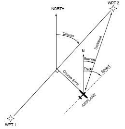
So I can see that someone could be mislead into thinking that 'Track' somehow provides a corrective value to regain DTK (or 'course') - but it emphatically does nothing of the kind.
And I agree that the GPS150 and GNC250 do not provide much SA - they're not intended to. Neither does a conventional VOR display, whether OBS or RMI.
I use GPS for navigation, but a chart for airspace SA. If you want to use a panel mounted moving map GPS for both, then fine. But the cost of fitting standard panel mounted GPS to club aircraft and maintaining their databases cannot really be justified at PPL training school level - they simply wouldn't provide a significant benefit for UK day VFR work to be cost-effective.
Not so! In the diagram the aircraft is off the planned track. TRK and DTK are the same - the aircraft is parallel to, but not on, the planned track. BRG is the track the aircraft would need to fly from the point shown direct to the wpt without using the 'direct to' and effectively creating a new wpt at the present position.
Take a look at p99 of your Pilot III instructions and you'll find the exact same diagram (except that they use 'course' instead of the more correct DTK - and the 'North' is missing from the arrow:
Whereas it should be:
So I can see that someone could be mislead into thinking that 'Track' somehow provides a corrective value to regain DTK (or 'course') - but it emphatically does nothing of the kind.
And I agree that the GPS150 and GNC250 do not provide much SA - they're not intended to. Neither does a conventional VOR display, whether OBS or RMI.
I use GPS for navigation, but a chart for airspace SA. If you want to use a panel mounted moving map GPS for both, then fine. But the cost of fitting standard panel mounted GPS to club aircraft and maintaining their databases cannot really be justified at PPL training school level - they simply wouldn't provide a significant benefit for UK day VFR work to be cost-effective.
Last edited by BEagle; 23rd Oct 2007 at 09:34.
Join Date: Oct 2003
Location: UK
Posts: 510
Likes: 0
Received 0 Likes
on
0 Posts
They might give a CDI-like cross track error readout, relative to a preprogrammed track, but they give precisely zero (zero) situational awareness
GPS cannot be used as a substitute for proper preplanning, although it is tempting with a moving map to jump in switch on and go, loading the plan on the first leg.
Also for someone who bangs on about SA, it is strange that IO540 doesn't use a whiz wheel which gives wonderful SA when it comes to understanding the effect of wind!

I've just looked at IO540 recommendation for a GPS, the KMD150. Yours for 2100 notes. What's that, a years worth of flying for an average ppl? Two years? I think you are in a different budget league to most ppls IO.
Join Date: Jun 2003
Location: EuroGA.org
Posts: 13,787
Likes: 0
Received 0 Likes
on
0 Posts
I use GPS for navigation, but a chart for airspace SA.
Most people use the printed chart for airspace reference, because the GPS maps don't have clear labels. (Unless one is running the real VFR charts as a moving map). However, a chart is completely useless unless you are very sure of your position on it.
A GPS which delivers only a "CDI" function, like a VOR CDI, tells you the position relative to a preprogrammed track, which is fine if you stick totally to the preprogrammed track, but is useless if one is just bimbling around.
I reckon most CAS busts are done either during unplanned flight (bimbling) or during an ad hoc diversion from a preplanned flight.
That is where a moving map comes in. You can see where you are on the map. But you know this already..........
If you want to use a panel mounted moving map GPS for both, then fine. But the cost of fitting standard panel mounted GPS to club aircraft and maintaining their databases cannot really be justified at PPL training school level - they simply wouldn't provide a significant benefit for UK day VFR work to be cost-effective
Well that is true but that is a separate issue. I have already acknowledged that there is no chance of modernising the PPL nav, due to flying schools not wanting to spend the money. This will happen only over many years, as the current old fleet is scrapped.
The database update issue isn't such a big deal. How often does the average PPL update his chart? Once a year! The CAA churns out a chart only once a year (usually).
I update my VFR databases once a year, maybe. IFR is something else - every 14 or 28 days.
Also for someone who bangs on about SA, it is strange that IO540 doesn't use a whiz wheel which gives wonderful SA when it comes to understanding the effect of wind!