


Low cost GPS units (yes, GPS again, yawn...)

Thread Starter
Join Date: Oct 2003
Location: Shropshire UK
Posts: 107
Likes: 0
Received 0 Likes
on
0 Posts
Low cost GPS units (yes, GPS again, yawn...)
Question for all you technical experts here in PPruneland.
Retail park outlets are now offering colour moving map gps for the car from Ł79.00 upwards eg navman f20 at Ł120
They seem to have selectable 2d or 3d map view, an installed roads database, and loads of other stuff I would want to switch off like voice command and touch screen. And they DO have a memory card slot.
So my question is, can it be made to read CAA charts from the memory card, (what's involved in scanning them in?) and what else would stop me using a unit in this way?
Second question is more plaintive - why are handheld satnavs for cars getting so cheap when aviation GPS is getting dearer? even the Ł=$ advantage has disappeared!
regards
HnH

Join Date: Jun 2003
Location: EuroGA.org
Posts: 13,787
Likes: 0
Received 0 Likes
on
0 Posts
In short, the answer is no and no 
Almost all maps in Europe are tightly controlled commercially, and the CAA charts - like all other aviation charts - are very expensive in electronic form.
You can get moving map GPSs which run those charts but all are pricey.
The road nav units are something else - they use data which is several years out of date, and the older it is the cheaper it is. They also sell in big volumes.
Yes it's frustrating to see all the technology in the shops and compare it with the utter cr*p methods which most people use to navigate in the air.
You can get decent nav kit; you can even get the plane to fly itself along the entire route, but it will cost you a packet.
If you are specifically after running the CAA charts as a moving map, the following are the options I know of:
1) Any PDA (pocket/pc) or a Windoze tablet computer, running Memory Map - MM sell the CAA charts at about Ł150 for the whole UK
2) A hardware product called Flymap - this will also run the Jeppesen Raster Charts which cover most of Europe - the pricing is stiff if you want the coverage.
3) Any PDA (pocket/pc) or a Windoze tablet computer, running Oziexplorer. OE is a generic moving map program which will run any map you can get in any common digital format and which you can calibrate (georeference). None of the aviation maps are officially available in the generic graphics formats, but there are "wayz"... and of course you can scan in your own printed charts (which is a real PITA).
This was discussed here recently. Do a search on Memory Map, Jeppesen Flitemap, raster charts, etc.
One quick comment is that the CAA charts are not really usable on a small screen. Running them on a 4" PDA is like viewing the printed chart through binoculars. You need at least a 7" or 8" diagonal screen to see enough of the chart to see airspace labels etc.
Join Date: May 2006
Location: uk
Posts: 360
Likes: 0
Received 0 Likes
on
0 Posts
Join Date: May 2001
Location: UK
Posts: 4,631
Likes: 0
Received 0 Likes
on
0 Posts
Yes, but I think you have missed the point.
PFMS is a great piece of software and it does run on PDAs, but PDAs have their limitations - small screens, and instability.
PFMS is crying out for a decent sunlight readable platform on which to operate - very few tablets offer sun light readable lcds and those that do are expensive.
The next generation of sunlight readable lcds for cars are the perfect size but whats needed is an open architect platform on which to run software such as PFMS - unfortunately it does not exist at the moment.
Thread Starter
Join Date: Oct 2003
Location: Shropshire UK
Posts: 107
Likes: 0
Received 0 Likes
on
0 Posts
Thanks for taking the time guys
I kind of suspected that there would be no "free lunch" here, but we live in hope.
Since I'm essentially a chart & wristwatch VFR navigator, the GPS idea is a backup (no, really!) and there wouldn't be a good return on investing in a serious bit of pilot-specific kit. Why - we might be talking the price of 24 hours flying here at our marginal wet rate of Ł25/h.
My pre-millenium magellan non-map does basic routes if I can be a**ed to programme it beforehand, but at least it gives me a distance, bearing and groundspeed.
The PDA method (even if display quality was acceptable) is a non starter as I already have one for work (with all it's useful connectivity removed for security reasons) and I'm blowed if i'm buying another one just to fly with.
Thanks anyway - I'll just have to wait until market forces assert themselves.
Good thing I'm a "late majority adopter" in the old jargon of consumer segmentation.
regards
HnH

Join Date: May 2007
Location: Portugal
Posts: 5
Likes: 0
Received 0 Likes
on
0 Posts
Here´s another who just bought a Garmin 196, never having used a GPS unit before in my life. I think it´s brilliant, and am 100% satisfied (so far) with it.
Very user friendly, and lots of easy to access info, not only the usual you expect from a "normal" GPS unit, but also all kinds of aviation specific info (including airspace warnings when you are heading into any sort of controled airspace, dangerous areas, forbiden areas, etc...radio navigation frequencies, all airports and airfields, etc...)
I paid more than the Ł339 mentioned (that´s a great price!), but still found it an excelent buy.
Thread Starter
Join Date: Oct 2003
Location: Shropshire UK
Posts: 107
Likes: 0
Received 0 Likes
on
0 Posts
Thanks for the reccomendation Sierra and Chris.
Looks like a great unit and I'm glad you're happy with the 196.
It's a bargain at Ł339, and I could probably rationalise that, but it's still a chunk of money for grayscale display, compared with the colour in-car derived units.
Decisions Decisions!
regards
HnH
Looks like a great unit and I'm glad you're happy with the 196.
It's a bargain at Ł339, and I could probably rationalise that, but it's still a chunk of money for grayscale display, compared with the colour in-car derived units.
Decisions Decisions!
regards
HnH
Join Date: Apr 2003
Location: Midlands
Posts: 2,359
Likes: 0
Received 0 Likes
on
0 Posts
I have a 196, and the display is much more readable in the aircraft than some of the colour aviation units. The log s/w and the ability to link to Navbox is also very good. The Flymap is better, but at Ł650 + it would have to be.
Rod1
Rod1
Join Date: Jul 2001
Location: chances are, not at home
Posts: 334
Likes: 0
Received 0 Likes
on
0 Posts
I never cease to be amazed at the sums people are prepared to spend on moving maps. All you need is
A PDA, linked in some way to a GPS (cable, bluetooth, SD card insert, integral). A modern 3.5" backlit screen is perfectly readable for me, once it has been oriented away from reflections.
Software (I use Seeyou [Ł50?] which is designed for gliding but is easily configured for powered). The really skint could use XCSoar which is free.
Free airspace files from http://soaringweb.org/SUA.
- job done, for peanuts.
Thread Starter
Join Date: Oct 2003
Location: Shropshire UK
Posts: 107
Likes: 0
Received 0 Likes
on
0 Posts
Joe thanks.
So help me out here - what's an appropriate make/model of PDA at minimum cost to do the job?
I can google GPS mice etc it's the subtle PDA variations/ operating systems/ that are a mystery.
Could you recommend a winning hardware combo (available in the uk)?
regards
HnH
So help me out here - what's an appropriate make/model of PDA at minimum cost to do the job?
I can google GPS mice etc it's the subtle PDA variations/ operating systems/ that are a mystery.
Could you recommend a winning hardware combo (available in the uk)?
regards
HnH
Join Date: Jul 2001
Location: chances are, not at home
Posts: 334
Likes: 0
Received 0 Likes
on
0 Posts
You're asking the wrong guy about technical stuff. I got a Compaq Ipaq 3800, real old on ebay Ł25. Wiring I did myself with bits around the house (see http://webadventures.com.au/ipaq_cambr.html for guide) but severn valley sailplanes do cables and mounts http://www.svsp.co.uk/Shop%20Website...GPS_Cables.htm
I bodged up a mount from an old hanggliding vario mount.
I had seeyou software anyway (runs fine on PDAwin or whatever its called), so total spend Ł25 plus Ł5 for a ciggie charger from Honkers.
Choosing now, I would get a HP iPAQ rx5935, with integrated GPS.
I bodged up a mount from an old hanggliding vario mount.
I had seeyou software anyway (runs fine on PDAwin or whatever its called), so total spend Ł25 plus Ł5 for a ciggie charger from Honkers.
Choosing now, I would get a HP iPAQ rx5935, with integrated GPS.
Last edited by Joe le Taxi; 19th Jun 2007 at 23:14.
Thread Starter
Join Date: Oct 2003
Location: Shropshire UK
Posts: 107
Likes: 0
Received 0 Likes
on
0 Posts
Thanks Joe
Looks impressively technical to me. I'll haunt ebay for a bit and see whats on.
The ASUS looks good too.
(and TopCat - thanks for the pm)
regards
HnH
Looks impressively technical to me. I'll haunt ebay for a bit and see whats on.
The ASUS looks good too.
(and TopCat - thanks for the pm)
regards
HnH
Join Date: Dec 2006
Location: Nowhere
Posts: 22
Likes: 0
Received 0 Likes
on
0 Posts
Hi everyone!
I've been searching around and found this:
http://approach-systems.com
They seem to have quite a good package. Do any pruners use it? If so, how good is it?
Just wondering ,
,
don't_ask
(Posted this before and it didn't work)
I've been searching around and found this:
http://approach-systems.com
They seem to have quite a good package. Do any pruners use it? If so, how good is it?
Just wondering
,don't_ask
(Posted this before and it didn't work)
Join Date: Jul 2005
Location: SoCal
Posts: 1,929
Likes: 0
Received 0 Likes
on
0 Posts
Garmin 96 (or 96c if you must have color). Little gem, comes with PC software to program your routes and plot your tracks and a sort of electronic logbook. Updateable and, if you so wish, can take road navigation sw as well (although I think you cannot have both on there at any one time). Cost approx GBP 230 / 280 for color. Only think I'd add is the external antenna, makes a huge difference in satellite reception.
Join Date: Aug 2006
Location: UK
Posts: 150
Likes: 0
Received 0 Likes
on
0 Posts
H&H
I have done just exactly what you are after and it cost me Ł20. Literally in the last few weeks.
Some of the comments above are not correct or at least aimed at someone who wishes to do a lot more with a GPS.
I have just passed my PPL and want to continue to use DD with map and compass and have a GPS as a backup.
I use a Orange m1000 PDA (O2 XDA II is the same). This is a QVGA 3.5 inch screen it is perfectly usable in the sunlight. I already had the Tom Tom software with this and hence a bluetooth GPS receiver also.
So all I have done is installed Memory Map software which cost Ł20 including the digitized CAA half mil Southern Chart. I can certainly recommend it for use as a moving map with the CAA chart.
The beauty is you are using the paper chart as the main navigation aid. The PDA GPS plot shows you where you are exactly in relation to the chart. Screen size and resolution is not a problem.
You can pick up the the PDA above for Ł20~Ł30 on ebay and probably a little less for the GPS. I think the latter models of the PDA come with built in GPS.
Battery life of the GPS is well over 6 hours. Battery life of the PDA about 4 or 5.
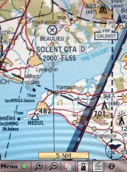
Here's a screen shot of the PDA. Quality in real life is better
Edit,
The pic above is the exact real world size of the PDA screen. (it's my PDA taken with my digital camera )
I have done just exactly what you are after and it cost me Ł20. Literally in the last few weeks.
Some of the comments above are not correct or at least aimed at someone who wishes to do a lot more with a GPS.
I have just passed my PPL and want to continue to use DD with map and compass and have a GPS as a backup.
I use a Orange m1000 PDA (O2 XDA II is the same). This is a QVGA 3.5 inch screen it is perfectly usable in the sunlight. I already had the Tom Tom software with this and hence a bluetooth GPS receiver also.
So all I have done is installed Memory Map software which cost Ł20 including the digitized CAA half mil Southern Chart. I can certainly recommend it for use as a moving map with the CAA chart.
The beauty is you are using the paper chart as the main navigation aid. The PDA GPS plot shows you where you are exactly in relation to the chart. Screen size and resolution is not a problem.
You can pick up the the PDA above for Ł20~Ł30 on ebay and probably a little less for the GPS. I think the latter models of the PDA come with built in GPS.
Battery life of the GPS is well over 6 hours. Battery life of the PDA about 4 or 5.
Here's a screen shot of the PDA. Quality in real life is better
Edit,
The pic above is the exact real world size of the PDA screen. (it's my PDA taken with my digital camera )
Last edited by JP1; 1st Apr 2008 at 19:46. Reason: in message and screen size is 3.5 not 2.5
Join Date: Sep 2002
Location: Savannah GA & Portsmouth UK
Posts: 1,784
Likes: 0
Received 0 Likes
on
0 Posts
Another Garmin 196 user.
I have enough trouble hitting the right bits of the screen on a TomTom in the car, I hate to think how I'd get on jabbing a PDA screen.
My method
Draw the route on NavBox ProPlan, upload it to the 196. Get the weather and NOTAM, print the PLOG & freqs from ProPlan having put the wind vector in.
Go flying
I have the update subscription for ProPlan which ensures I know where the airspace is when I draw the route. Once the route's in the GPS I can pull it up and use it whenever I want.
I also have Cub's VFR waypoints. Loaded into the GPS. Thanks Cub!
I prefer to fly with a track up display. Most GPS displays put you a third of the way up from the bottom so your greatest visibility range is in the upward direction, not so good if you're heading downwards. Being a bear of very little brain I prefer to have all of the wording on the display the right way up, even if I'm heading south, and I like to turn left if the little aeroplane is to the right of the line I want rather than having to turn the whole thing round in my head. The CDI and the rest of the data that's available on the aviation GPS is also useful. Also useful is the way the amount of data displayed increases when you zoom in and decreases when you zoom out.
Would you rate TomTom highly if it had the wording upside down when you drove south or if your direction of travel was contantly changing on the map because you were stuck with a north-up display?
