


iPhone apps for Pilots


Is it the old one from years ago before they withdrew it?
I thought the DAFIF was no longer made publicly available as AirServices tried to hold copyright over the(ir) Australia data. As such, the Yanks said get stuffed and from then on just keep all the data in house.
After a bunch of work we are very excited to announce that AvPlan is now available from the Apple App Store.
It is a free download and a fully featured trial will be active for a month.
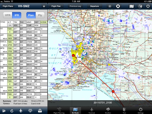
The app is then available as a subscription;
If you like the app and choose to subscribe, please do so via our website at www.avsoft.com.au for a discount over the prices available inside the app.
Thanks,
Bevan..
It is a free download and a fully featured trial will be active for a month.
The app is then available as a subscription;
- Flight planning with full NAIPS integration for weather, NOTAMS, plan submission and more.
- VFR Upgrade Pack (ERSA, VNC, VTC and WAC charts)
- IFR Upgrade Pack (VFR plus DAP, ERC H, ERC L and TAC charts)
If you like the app and choose to subscribe, please do so via our website at www.avsoft.com.au for a discount over the prices available inside the app.
Thanks,
Bevan..
Hi Flyboy_NZ
Its currently only an iPad app, so if you are looking from an iPhone or iPod touch you wont see it.
The next version will support the iPhone as well. Thanks for passing on the good word.
Bevan..
Its currently only an iPad app, so if you are looking from an iPhone or iPod touch you wont see it.
The next version will support the iPhone as well. Thanks for passing on the good word.
Bevan..
Hi
There are two ways;
1.
Click on the map around where the waypoint you wish to insert is, the 'select nearest' view appears.
There are two buttons there; add | insert.
Select insert, tap on + on the waypoint row you wish to insert. Another view of the current waypoints in the plan will appear and then select waypoint you wish to insert before.
2. Add a waypoint at the end, then edit the plan with the left most button at the bottom of the flight plan. The row can be picked up and moved to the point you want. Press edit again to take the plan out of edit mode.
Note that with the plan in edit mode you can edit more parts of the plan, such as the winds for each leg if you want to manually change it.
Thanks,
Bevan..
Avplan - a few observations/questions
Got this yesterday and have been playing around with it, very good app!
In regards to the weather, is there a way to manually refresh the data of eg. The arfor as when I hit the refresh button at the bottom the data didn't change.
Also how do I set an aircraft to use for the current flight plan? (n00b me)
Back to weather, when viewing the naips weather the iPad is picking up strings of numbers such as the temps as possible contacts and is hyperlinking them - an easy fix I'm sure
Cheers
Last edited by Power; 11th Aug 2011 at 22:35.
Hi Power
To refresh a forecast for a plan, press the refresh button like you are doing. However, it will only re-download a forecast if the previous one is over 15 minutes old.
It will then reapply winds etc to the plan.
To set an aircraft, press the aircraft symbol, select the type, then the particular callsign. If there is a detailed performance model for that type, select the performance model. It will then recalculate the plan, and you will see the type in the footer of the plan, and the callsign in the header of the plan.
Good point about the numbers etc in the forecasts. There was a debate about this, and it was left in so you can just press on phone numbers in forecasts etc as required.
Thanks for giving it a go.
Bevan..
Join Date: May 2006
Location: Australia
Posts: 137
Likes: 0
Received 0 Likes
on
0 Posts
Maybe for future updates Avplan might be able to load automatically the taf and terminal charts for their respective waypoints from the flight plan.
It would be good to have these grouped together in the terminal screen at the touch of a button for that required flight for easy access
Would i be right in saying the only way at the moment to get these is to load them independenly from the ersa/dap book button on the right top of screen
Look forward to using it in the air
Hi Jay Bo
If you tap on a row in the flight plan it will open the terminal tab with that waypoint, complete with TAF's and NOTAMs for that point. Scroll left and right then for applicable ERSA/DAP pages.
It also remembers which page you were viewing, so if you tap between plan waypoints you will go back to the particular ERSA/DAP page you were viewing at that point.
Hope that helps
Thanks,
Bevan..
Join Date: Jun 2011
Location: Australia
Posts: 42
Likes: 0
Received 0 Likes
on
0 Posts
Great App Bevan. You've obviously put a lot of hard work into it.
Tried it airborne the other day with the recommended iPad Kneeboard. Very good and a great combo. Can you explain a little more on when BOM Radar overlays work whilst Airborne? You mentioned on the website it works with some maps.
Tried it airborne the other day with the recommended iPad Kneeboard. Very good and a great combo. Can you explain a little more on when BOM Radar overlays work whilst Airborne? You mentioned on the website it works with some maps.
Last edited by MilFlyer; 17th Aug 2011 at 08:13.
Hi Folks
The ability to edit/delete user waypoints will come in a update very soon.
As for the BOM radar overlay - it works on the WAC's and VTC's at the moment - the radar button will only enable on those types. Anything else will be coming in an update shortly.
Thanks for taking the time to try it out.
Bevan..
Join Date: Apr 2009
Location: Maun, Botswana
Age: 37
Posts: 424
Likes: 0
Received 0 Likes
on
0 Posts
Hey guys,
I've been sifting through the 13 pages and haven't really come up with anything.
Is there any apps for a world wide kinda thing?
I'm currently flying in Africa, but will either be in Canada or PNG in the next few months. I'd prefer to get something that isnt just limited to one country.
Cheers!
I've been sifting through the 13 pages and haven't really come up with anything.
Is there any apps for a world wide kinda thing?
I'm currently flying in Africa, but will either be in Canada or PNG in the next few months. I'd prefer to get something that isnt just limited to one country.
Cheers!