


Interesting airstrips


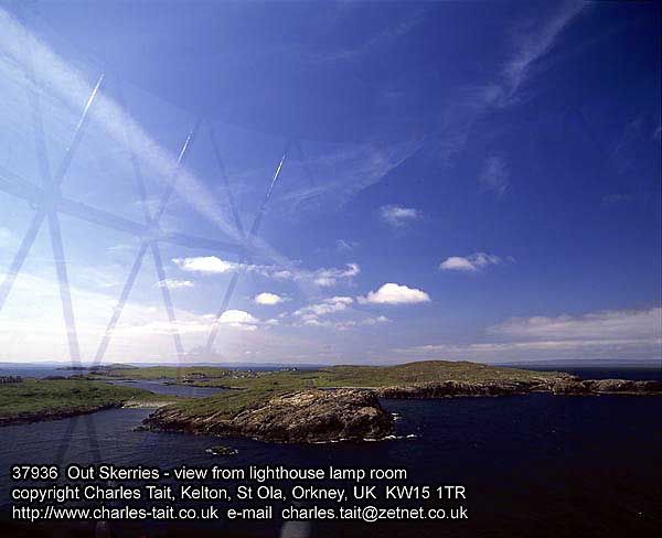
Out Skerries, Shetland Islands, UK. Taken from the lighthouse which lies directly on final for RWY 27 (381m) so the image is equivalent to a short-ish but early final. Usually I turned final at the lighthouse about level with its light, staying downwind of it so the often gale-force wind wouldn't push me into the tower. Used to fly at night into here for air ambulance flights. They only had gooseneck flares when I started with the company.
The runway is visible just above the rocky island in the foreground. I think the photographer has used a wide-ish angle lens - the strip doesn't really look that small at this distance.
Out Skerries.
...and from or near the threshold looking in the opposite direction:
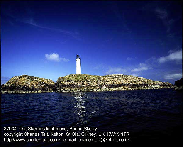
towards lighthouse from upwind end of Rwy 09
Image source: www.charles-tait.co.uk. Used with permission.
The runway is visible just above the rocky island in the foreground. I think the photographer has used a wide-ish angle lens - the strip doesn't really look that small at this distance.
Out Skerries.
...and from or near the threshold looking in the opposite direction:
towards lighthouse from upwind end of Rwy 09
Image source: www.charles-tait.co.uk. Used with permission.
Last edited by Tinstaafl; 14th Oct 2006 at 00:42.
Join Date: Aug 2004
Location: Auckland
Posts: 67
Likes: 0
Received 0 Likes
on
0 Posts
The grass strip with no explanation on the first page is good ol Tangahoe.
About 20nm west of National Park Village, Nth Is, NZ.
One way 400m. Land at the camera and up the two rises to the top. Roll from the top and run down towards the camera. If your light you can be airborne from the first bump (bout 30m) Behind the camera it drops of considerabley into a valley. If you miss the sheep, deer and pigs your half way home and once you pop into the valley you're home and hosed.
No sweat for the dirty DOV! even with Dave and his travelling band of B.O bandits.
Its got nothing on those PNG strips, hats off to you but still it's a pretty cool tiger country mission.
About 20nm west of National Park Village,
Nth Is, NZ.One way 400m. Land at the camera and up the two rises to the top. Roll from the top and run down towards the camera. If your light you can be airborne from the first bump (bout 30m) Behind the camera it drops of considerabley into a valley. If you miss the sheep, deer and pigs your half way home and once you pop into the valley you're home and hosed.
No sweat for the dirty DOV! even with Dave and his travelling band of B.O bandits.
Its got nothing on those PNG strips, hats off to you
but still it's a pretty cool tiger country mission.
Yeah. One of the few. Every so often there'd be a run of a week or so. In summer it was a heatwave if the temp. broke 20 deg C. Nearly always windy! Lost track of the >40kt days I flew into these strips. Weirdest thing was the 'Har' - a fog bank from the North Sea that would roll in with a 20 or 30 kt breeze. Quite strange to stand & watch a wall of fog roll over the top of you & then stream past at 20+ kts. Had a few moments where I had to race it to an airstrip.
Out Skerries was the shortest but by no means the most difficult. Two other strips were ~450m but had cliffs or other rock forms that would render them unuseable above 15 or 20 kts if the wind was from the wrong direction. Really nasty vortices would form & roll over the strips or their appr./dept. paths.
Out Skerries was the shortest but by no means the most difficult. Two other strips were ~450m but had cliffs or other rock forms that would render them unuseable above 15 or 20 kts if the wind was from the wrong direction. Really nasty vortices would form & roll over the strips or their appr./dept. paths.
