


What's happening near Lyneham?

Thread Starter
Join Date: Feb 2006
Location: Hanging off the end of a thread
Posts: 33,077
Received 2,942 Likes
on
1,253 Posts
What's happening near Lyneham?
Seen this? Off topicish, but weird.
Mystery as road is ripped up by 'unexplained underground movements' (msn.com)
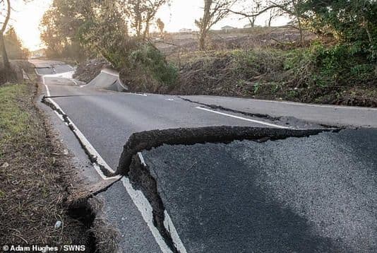
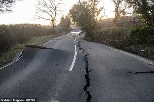
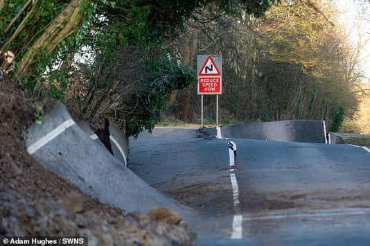
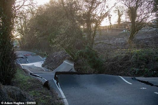
A ripped up road could cost millions to repair after mysterious underground movements left it so warped it looks like it had been hit by an earthquake.
A section of the B4069 near Lyneham in Wiltshire has been so badly damaged the tarmac has completely snapped or is at a 45 degree angle.
Wiltshire Council say the road has been closed since February 17 - but some drivers are still trying to use it according to police.
The earthquake-like damage has been caused by unexplained underground movements which will now be investigated.
Local residents claim the subsidence has been getting worse over the last year and a landslip was inevitable.

Avoid imitations
Join Date: Nov 2000
Location: Wandering the FIR and cyberspace often at highly unsociable times
Posts: 14,580
Received 436 Likes
on
230 Posts
These things aren't unheard of. The main A625 road that ran via the Hope Valley and Castleton to Chapel-en-le-Frith slid away altogether in the 1970s due to ground instability, despite repeated repair attempts. The land is still moving, even today and the road was permanently closed in 1979.
https://www.bgs.ac.uk/case-studies/m...de-case-study/
https://www.bgs.ac.uk/case-studies/m...de-case-study/


Join Date: Dec 2000
Location: Canada
Posts: 54
Likes: 0
Received 0 Likes
on
0 Posts
Boring answer detailed in link below
https://www.newcivilengineer.com/lat...ed-24-02-2022/
https://www.newcivilengineer.com/lat...ed-24-02-2022/
Probably not helped by the fact a large area just above the road has a) been cleared of vegetation b) Had a fairly large dwelling built on it and c) a large drive/parking area constructed. ... all of which will lead to a large amount of surface water runoff with no-where to go but down to the road edge... where it probably collected before going "under" the road .... with the effects as seen and described
I lived in Calne for 8 years and drove that way to the M4 about half the time. Always had running water on the first steep downhill left hand coming out of Lyneham (in Winter not unusual to see cars down the bank due to that). Don't recall seeing running water on the part of the road down Dauntsey bank. But it did get more and more undulating as time went on. They re-laid the top of the bank (the section that failed here) at least once in that time.
Perhaps the best option is to abandon the current road and spend the money somewhere else, after all they've managed without it for some considerable time.
I'm waiting to see who is first to say it's all down to climate change.
Old Duffer
I'm waiting to see who is first to say it's all down to climate change.
Old Duffer
I blame Pritti Patel myself.........................
Probably someone took the anti gravity test vehicle for drive from the UFO space port located �not far from there � in light years .
Some Glastonbury types , pockets filled with spice attempt to fold time and space fail due to wrong type of spice ?
Some Glastonbury types , pockets filled with spice attempt to fold time and space fail due to wrong type of spice ?
Avoid imitations
Join Date: Nov 2000
Location: Wandering the FIR and cyberspace often at highly unsociable times
Posts: 14,580
Received 436 Likes
on
230 Posts
I think we’re probably going to see applications for fracking to begin again, post Ukraine.
Avoid imitations
Join Date: Nov 2000
Location: Wandering the FIR and cyberspace often at highly unsociable times
Posts: 14,580
Received 436 Likes
on
230 Posts
I read years ago that many ancient woodland areas are in effect "floating" on water. Perhaps this is the case here. The water table level has perhaps risen due to greatly increased rainwater run-off caused by the upper slope being cleared, forcing the previously relatively dry ground below the road upwards.

