


Operation TOP HAT - The establishment of RNAS Rockall in 1971

Thread Starter
Operation TOP HAT - The establishment of RNAS Rockall in 1971
My eye was caught on another forum by a recent response to a Freedom of Information request about an expedition to install a flat space on Rockall for the erection of an all-round light in 1971. The original poster has given me his blessing to share it and the linked, well-illustrated report may be of interest:

I know of another rock elsewhere in the world which was 'claimed' by the Royal Navy. It's called 'HMS Diamond Rock' and is still considered to be a commisioned vessel; RN ships will dip their flags in salute as they pass it.

Another protrusion from the Earth called Lumatan had a similar treatment in 1966. The was a hill in North Borneo that was being used as a rebro station by the army. It was difficult to get at so the decision was made to clear the top for a helipad.
The Ghurkha Engineers went in and the Officer, an ex South African mining engineer sliced the top off like topping an egg. The result was perfect and everybody was happy.
Some time later the a Royal Engineers survey party pitched up wanted to go to the top of Lumatan. The reason was that they needed to do some map work and Lumatan was the main trig point for southern Sabah.
The whole of Borneo had sunk about eight feet.
Join Date: Apr 2010
Location: London
Posts: 7,072
Likes: 0
Received 0 Likes
on
0 Posts
Brilliant move - we were able to snaffle zillions of sq kms west of Shetland into our Economic Zone - fish, oil & gas........
any similarities with reefs in the S China Sea is purely co-incidental.............
any similarities with reefs in the S China Sea is purely co-incidental.............
Join Date: Oct 2004
Location: UK
Posts: 77
Likes: 0
Received 0 Likes
on
0 Posts
So there isn't much similarity and therefore not much that can be coicidental.
Of course the UK could learn a lesson and follow China's lead and extend it's EEZ across the North Sea to the continent - out to the shores of Iceland and the RoI - and then into the Baltic.
Crossing the pond Westward on the Victor (and the Vulcan I assume) the nav radar always tried to get a final fix on Rockall, as it was the last chance before you coasted in over Canada. I was never quite sure if I had found it on the H2S - the thing to do was to tell the plotter confidently that you had, and that he could trust the fix!
Join Date: Sep 2012
Location: North of Watford, South of Watford Gap
Age: 68
Posts: 251
Likes: 0
Received 2 Likes
on
1 Post
Those of a certain age may remember the songs of Michael Flanders and Donald Swann, including one about the RN's planting a flag on Rockall in the 1950s. It included the lines:
We sailed acros the planet
To find this lump of granite;
One rather startled gannet;
In fact we found - Rock All!
I see what they meant...
We sailed acros the planet
To find this lump of granite;
One rather startled gannet;
In fact we found - Rock All!
I see what they meant...
My father told me that when they flew around the Atlantic on Bismuths, (weather reconnaissance flights) during the war Rockall was the only opportunity for the gunners to practise with their guns.
Join Date: Nov 2006
Location: Somewhere in England
Posts: 105
Likes: 0
Received 0 Likes
on
0 Posts
About here! https://goo.gl/maps/Cp9F8xSjPzr
Reminds me of the (possibly apochryphal) PA announcemt by a BA captain on a transatlantic flight around the time it was in the news (Tom Mclean living there I assume). "Those on the left hand side of the aircraft can see Rockall, those on the right can see something similar".
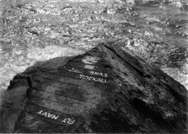
At one late 1960s Farnborough the Bucc flypast included opening (rotating) the bomb bay to show a massive day-glo red "FLY NAVY" to the crowd

I think you lot should start pouring sand and concrete around Rockall to increase it's size.
Perhaps build a port, even an airfield.
Install some anti-aircraft missiles...
Perhaps build a port, even an airfield.
Install some anti-aircraft missiles...
Join Date: Apr 2010
Location: London
Posts: 7,072
Likes: 0
Received 0 Likes
on
0 Posts
"The UK hasn't used Rockall to aggressively extend its EEZ"
True but it was still amajor bargaining chip....
ited Kingdom

Lieutenant Commander Desmond Scott hoists the Union Flag in 1955
The UK claims Rockall along with a 12-nautical-mile (22 km; 14 mi) territorial sea around the islet inside the country's exclusive economic zone (EEZ).[59] The UK also claims "a circle of UK sovereign airspace over the islet of Rockall".[59]
The UK annexed Rockall on 18 September 1955 when "Two Royal Marines and a civilian naturalist, led by Royal Navy officer Lieutenant Commander Desmond Scott, raised a Union flag on the island and cemented a plaque into the rock".[60] In 1972, the British Island of Rockall Act formally annexed Rockall to the United Kingdom. The UK considers the island administratively part of the Isle of Harris and, under the Scottish Adjacent Waters Boundaries Order 1999 a large sea area around it was declared to be under the jurisdiction of Scots law. A navigational beacon was installed on the island in 1982 and the UK declared that no ship would be allowed within a 50-mile (80 km) radius of the rock.[61] However, in 1997, the UK ratified the United Nations Convention on the Law of the Sea (UNCLOS), limiting territorial sea claims to a 12-nautical-mile, or 14 mile (22 km), radius, and therefore allowing free passage in waters beyond this.
A territorial claim could form the basis for an extended EEZ. However, in 1988, the United Kingdom and Ireland signed an EEZ boundary agreement for which "the location of Rockall was irrelevant to the determination of the boundary".[2] In 1997, the UK ratified UNCLOS, which states that "Rocks which cannot sustain human habitation or economic life of their own shall have no exclusive economic zone or continental shelf".
As the rock lies within the United Kingdom's EEZ, the UK has exclusive rights and obligations in relation to the exploitation, conservation and management of the rock itself.[4]
Ireland

The position of Rockall (centre of grey disc) with respect to the claimed Irish EEZ.[5]
Irish claims to Rockall have been based on its proximity to the Irish mainland,[62] however the country has never formally claimed sovereignty over the rock. Ireland formally rejected the British territorial claim to Rockall, "which would be the basis for a claim to a 12-mile territorial sea".[63]
Ireland regards Rockall as irrelevant when determining the boundaries of the Exclusive Economic Zones (EEZ) as the rock is uninhabitable.[2][64][65] In signing the United Nations Convention on the Law of the Sea (UNCLOS) in 1997, the UK has agreed that "Rocks which cannot sustain human habitation or economic life of their own shall have no exclusive economic zone or continental shelf".
In 1988, Ireland and the United Kingdom signed an EEZ boundary agreement, ignoring the rock per UNCLOS.[2] With effect from 31 March 2014, the UK and Ireland published EEZ limits which include Rockall within the UK's EEZ.[4][5]
In October 2012, the Irish Independent published a picture of the Irish Navy ship R�is�n sailing past Rockall conducting routine maritime security patrols, and claimed that it was exercising Ireland's sovereign rights over the rock.[66] In 2014 the OSI survey of Irish Territorial waters included the Rockall bank.[67]
