


P47 crash near Hastings 23 July 1944

Thread Starter
P47 crash near Hastings 23 July 1944
Help!! 
I'm trying to locate the modern map references for the crash site.
My friend believes it crashed close to his farm.
He's obtained the crash record but can't relate the WW2 co-ordinates to modern day ones.
QUOTE: The MR numbers are: 217327 (Beauport), and 226343 for the Kent Street . UNQUOTE
Can anyone unravel this, please?
Any further information would be useful, too

Have a look at this: https://en.wikipedia.org/wiki/Cassini_Grid and here: https://web.archive.org/web/20150929...ology/maps.asp
Thread Starter
Thanks all and the date was in 1944 at 1648
Converting wR217327 locates woodland just north west of Beauport Park and wR226343 is north east of Bluemans Lane, Battle, near Hastings, East Sussex.
50.898861193657, 0.53297020768071 and 50.913047989944, 0.54629803664672
The locations are no too far apart, but confused as to why two were given, unless the wreckage fell apart in mid air..
Thread Starter
UPDATE: Fresh details are that there were TWO P47's involved, yet another mid air collision over Battle area!
QUOTE: The reports for both planes are archived in ESCR.RAF/257/70/44, and RAF/254/65/44
The aircraft were attached to 53 Fighter Squadron AAF 418 station, based at King's Norton.
The planes were part of a formation of Thunderbolt "Jugs" heading to support the Allied advance in Normandy. The report was sent to RAF Friston and Saffron Walden, and I suspect they had taken off from Debden, bearing in mind the report states they were on a South Westerly heading. It says the two planes collided in cloud over Battle, so I imagine they were at between 10 and 25,000 feet, cruising at perhaps 340 knots. Both pilots baled out and survived.
The impacts may have been surprisingly gentle, because the wrecks were both on the surface. The one by Great Buxted retained two HE 500 lb bombs/ which were defused by Bomb disposal, and only one bomb exploded in the Beauport crash. Thinking of the trajectory of descent, I imagine the collision was somewhere over Wadhurst.
I (Insert - my friend) have found various bits of the fuselage and a junction box cover in Beauport woods, adjacent to a ruined cottage, but this was variously called Ollivers, Grinsted's Cottage and Sally Isaacs - never "Dell Cottage" as mentioned in the report. There is also an apparent error in the Kent Street crash, which states it caused the A229 to be closed - this must mean the A21. UNQUOTE
That explains the two locations which puzzled me until now (Doesn't take much!)
The 53rd Fighter Squadron history per Wiki states:
"Transferred to III Fighter Command in June 1943, began training for deployment to the European Theatre of Operations as a Republic P-47 Thunderbolt fighter-bomber squadron.
Deployed to England in April 1944 as part of IX Fighter Command. Initial missions included strafing and dive-bombing armoured vehicles, trains, bridges, buildings, factories, troop concentrations, gun emplacements, airfields, and other targets in preparation for the invasion of Normandy. On D-Day the squadron patrolled the air over the landing zones and by flying close-support and interdiction missions.
Moved to its Advanced Landing Ground at Brucheville Airfield, France (A-16) in July, then eastward as ground forces advanced on the continent. Operations supported the breakthrough at Saint-L� in July
It would seem that 53rd Fighter Squadron moved AFTER 23rd July. It was stationed near Ashford, Kings NORTH AAF-418. It's Squadron Code was 6V
Kingsnorth was known as USAAF Station AAF-418 for security reasons by the USAAF during the war, and by which it was referred to instead of location. Its USAAF Station Code was "KN"
Movement to the Continent commenced during the first week of July when the 53rd Fighter Squadron transferred to its Advanced Landing Ground (ALG) at Brucheville, France (ALG A-16) as a forward base. The other two squadrons continued to operate from Kingsnorth until early August, the main body of the group preparing to move on the 2nd. Within a few days all personnel were gone and the airfield was deserted. Kingsnorth Airfield is on the east side of the A2070 just south of Ashford, about 1 mile south of Bad Munsterfeld road just after the loop heading southwards. The main airfield was in the field northwest of Bliby Corner crossroads, although the runways can be traced to south of Chequertree Lane.
Kingsnorth is about 25 miles from crash sites, so I'm assuming they would still be climbing to operational altitude, although close air support wouldn't require too much height, just sufficient to avoid the trigger happy AA fire on V1's that were active at that time.
That might account for the fairly "gentle" surface impacts reported on both aircraft.
Anyone have further info?
QUOTE: The reports for both planes are archived in ESCR.RAF/257/70/44, and RAF/254/65/44
The aircraft were attached to 53 Fighter Squadron AAF 418 station, based at King's Norton.
The planes were part of a formation of Thunderbolt "Jugs" heading to support the Allied advance in Normandy. The report was sent to RAF Friston and Saffron Walden, and I suspect they had taken off from Debden, bearing in mind the report states they were on a South Westerly heading. It says the two planes collided in cloud over Battle, so I imagine they were at between 10 and 25,000 feet, cruising at perhaps 340 knots. Both pilots baled out and survived.
The impacts may have been surprisingly gentle, because the wrecks were both on the surface. The one by Great Buxted retained two HE 500 lb bombs/ which were defused by Bomb disposal, and only one bomb exploded in the Beauport crash. Thinking of the trajectory of descent, I imagine the collision was somewhere over Wadhurst.
I (Insert - my friend) have found various bits of the fuselage and a junction box cover in Beauport woods, adjacent to a ruined cottage, but this was variously called Ollivers, Grinsted's Cottage and Sally Isaacs - never "Dell Cottage" as mentioned in the report. There is also an apparent error in the Kent Street crash, which states it caused the A229 to be closed - this must mean the A21. UNQUOTE
That explains the two locations which puzzled me until now
(Doesn't take much!)The 53rd Fighter Squadron history per Wiki states:
"Transferred to III Fighter Command in June 1943, began training for deployment to the European Theatre of Operations as a Republic P-47 Thunderbolt fighter-bomber squadron.
Deployed to England in April 1944 as part of IX Fighter Command. Initial missions included strafing and dive-bombing armoured vehicles, trains, bridges, buildings, factories, troop concentrations, gun emplacements, airfields, and other targets in preparation for the invasion of Normandy. On D-Day the squadron patrolled the air over the landing zones and by flying close-support and interdiction missions.
Moved to its Advanced Landing Ground at Brucheville Airfield, France (A-16) in July, then eastward as ground forces advanced on the continent. Operations supported the breakthrough at Saint-L� in July
It would seem that 53rd Fighter Squadron moved AFTER 23rd July. It was stationed near Ashford, Kings NORTH AAF-418. It's Squadron Code was 6V
Kingsnorth was known as USAAF Station AAF-418 for security reasons by the USAAF during the war, and by which it was referred to instead of location. Its USAAF Station Code was "KN"
Movement to the Continent commenced during the first week of July when the 53rd Fighter Squadron transferred to its Advanced Landing Ground (ALG) at Brucheville, France (ALG A-16) as a forward base. The other two squadrons continued to operate from Kingsnorth until early August, the main body of the group preparing to move on the 2nd. Within a few days all personnel were gone and the airfield was deserted. Kingsnorth Airfield is on the east side of the A2070 just south of Ashford, about 1 mile south of Bad Munsterfeld road just after the loop heading southwards. The main airfield was in the field northwest of Bliby Corner crossroads, although the runways can be traced to south of Chequertree Lane.
Kingsnorth is about 25 miles from crash sites, so I'm assuming they would still be climbing to operational altitude, although close air support wouldn't require too much height, just sufficient to avoid the trigger happy AA fire on V1's that were active at that time.
That might account for the fairly "gentle" surface impacts reported on both aircraft.
Anyone have further info?
Thread Starter
Ah, thanks ZH875, that clears that little aspect up
One pilot was William E Peto, and have found a photo of the Squadron from May 1944 which he sent to the American Air Museum, noting he flew 90 sorties and parachuted once - but no other details.
ZH875 - C130J? Was it you who flew right over my house on the Omen farewell tour? Brilliant
One pilot was William E Peto, and have found a photo of the Squadron from May 1944 which he sent to the American Air Museum, noting he flew 90 sorties and parachuted once - but no other details.
ZH875 - C130J? Was it you who flew right over my house on the Omen farewell tour? Brilliant
Unfortunately not. I was on the Engineering side of the C130J for a short time way back, and found PPRUNE, needed a moniker and as ZH875 was the best frame at the time, chose that.
Not sure if this is of any use but here's a cleaned up excerpt from the 1" Ordnance Survey map (Hastings Sheet 135, war revision of 1940), showing your area of interest. The A229 is clearly marked.
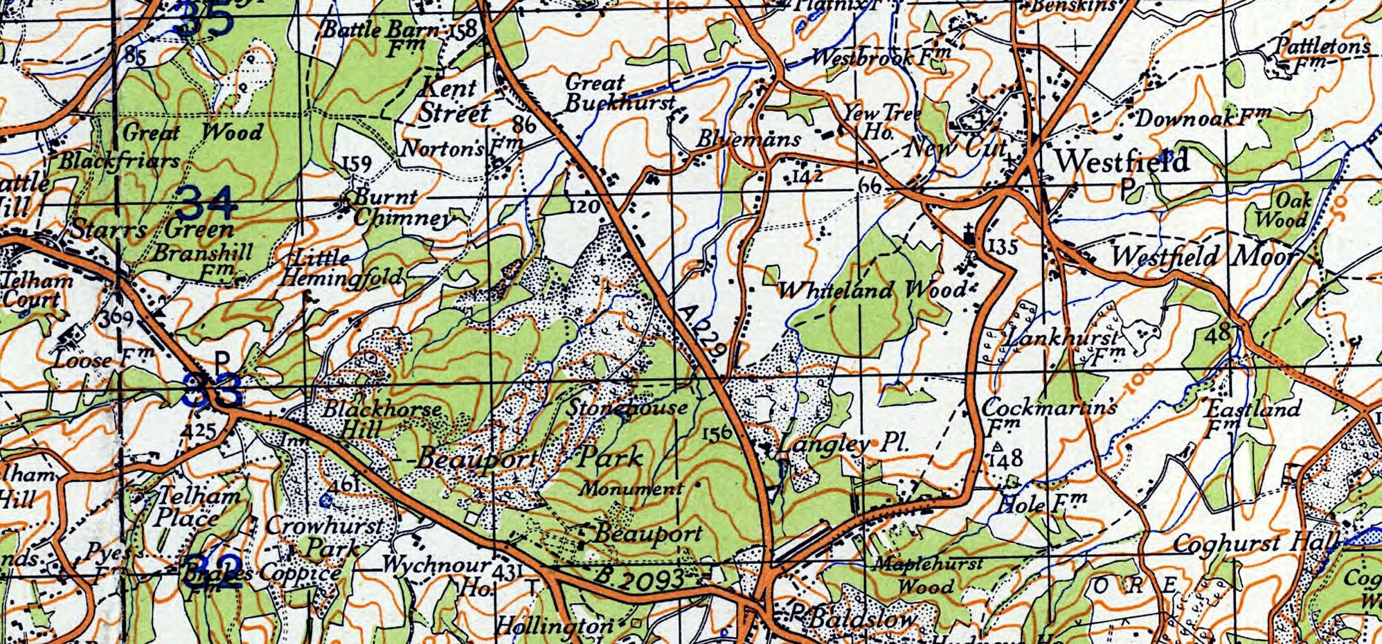
Thanks to the Australian Govt, and McMaster University (Canada) for the source material.
FP.
Thanks to the Australian Govt, and McMaster University (Canada) for the source material.
FP.

Join Date: Jan 2024
Location: battle, East Sussex
Posts: 1
Likes: 0
Received 0 Likes
on
0 Posts
Hi, The ruined cottage is on my property and is very difficult to find unless you know where it is (all under dirt and brush now). Happy for you to come and have a look, if you want. How do you know the name of the cottage?
