


Vulcan Crew Briefing?

I don't own this space under my name. I should have leased it while I still could
Range slots were every 10 minutes and for two ranges you needed slots that fitted your low level route times. Low level entry times were also 10 minute slots. As bombing slots were allocated to wings it was often difficult coordinating the timing.
They problem with a low level target was it guaranteed a low, high speed, noisy overflight. If it was an exercise and the target was near a farm you can imagine the noise over several hours.

As I remember it the captain would go to met and meet the rest of the crew in the Ops wing planning room . At T O - 3 and announce which low level portion of the route we would be doing. This was the round U.K. “link route” which had designated entry points : ie today the weather is fit EP 23 (Bass rock) to 30 ( Humberside Area). The plotter would then put together a high level NAVEX letting down to the LL entry point at a given time which had then to be booked. The Nav Rad meanwhile delved into his bag for a couple of simulated targets on that portion of the route. Added to this may have been a detail on a bombing range where up to 4 real 28 lb practice bombs may have been dropped. Depending on the aircraft fit these could have been simulating conventional or nuclear weapons. Then back to the circuit for instrument and visual circuits. Night sorties were much the same with the added fun of pre computing the Astro shots!
Happy Christmas to one and all.
TL
Happy Christmas to one and all.
TL
Excellent info, thanks all.
A bit bit more if I may - did you ever �attack� other installations, like power stations, road bridges etc as a practice for the war time role, or were attack profiles strictly limited to a range for a validated score?
I�ve often looked for a map of the low level routes from the 60s and 70s - would anyone be able to point me in the right direction (assuming it�s not secret of course).
I hope you are are all having a very merry Christmas wherever you are.
Before the late '70s, the 'main route' was a narrow LL corridor linking the small LFAs and the odd 'bomb plot' location. Fortunately that was all slung out in the late '70s when the UK LFAs were extended and the LL route was considerably widened. We could than plan sensible LL routes between visual points, so that visual map reading could back up the mysterious incantations uttered by the lower deck as they slaved over steaming '50s era ironmongery backed up with H2S. We also created a library of targets; some were visually significant whereas others were simply L/L positions, designed to test the offset bombing skills of the lower deck. Some (weaker) crews would still only attack 'direct' targets, whereas others worked as a team using 'all aids' bombing techniques. A few grumbling old QRA queens weren't up to this though, as they didn't like change... They could just about cope with EP 28-31 east coast routes, terminating with a Tumby bomb plot run, but that was about it.
In the hour or so before flight, co-pilots would now have to draw the 1/2 mill maps from LL entry point to climb out, rather than using the dinosaurs' pre-printed booklets. Then the IP-to-target 50 thou maps, having previously told the navigators where the visual IPs were. Normally LL routes were planned for still-air, with fatigue-saving transit speeds and around 320KIAS for the bomb run. In fact the techniques were much like Hunter/Bucc/F-4 LL planning, with the added benefit of an accurate NBS. But at lower IAS.
One of my favourite visual IPs was the 'Composite Signals Organisation Station' at Trickey Warren (RAF Culmhead as was) in the Blackdowns. A cluster of white buildings filled with GCHQ spooks right in the centre of the old RWs, it could be seen for miles - and we knew that they'd never complain about the racket of 4 x Olympus overhead at 300(ish) feet as we started the IP-to-Target runs...
Few trips ended up at an air weapons range in the late '70s and (apart from the odd exercise) virtually all bomb scores were derived from release point photos analysed by the Wing Weapons staff. If an attack resulted in a simulated impact outside the mandatory radius from target, a 'long bomb' report had to be written, explaining what had happened. So every bomb run was in fact an FRA - no reattacks were ever contemplated. Which really concentrated crew activity when the weather wasn't brilliant!
Great times, great fun too!
They could just about cope with EP 28-31 east coast routes, terminating with a Tumby bomb plot run, but that was about it.In the hour or so before flight, co-pilots would now have to draw the 1/2 mill maps from LL entry point to climb out, rather than using the dinosaurs' pre-printed booklets. Then the IP-to-target 50 thou maps, having previously told the navigators where the visual IPs were. Normally LL routes were planned for still-air, with fatigue-saving transit speeds and around 320KIAS for the bomb run. In fact the techniques were much like Hunter/Bucc/F-4 LL planning, with the added benefit of an accurate NBS. But at lower IAS.
One of my favourite visual IPs was the 'Composite Signals Organisation Station' at Trickey Warren (RAF Culmhead as was) in the Blackdowns. A cluster of white buildings filled with GCHQ spooks right in the centre of the old RWs, it could be seen for miles - and we knew that they'd never complain about the racket of 4 x Olympus overhead at 300(ish) feet as we started the IP-to-Target runs...
Few trips ended up at an air weapons range in the late '70s and (apart from the odd exercise) virtually all bomb scores were derived from release point photos analysed by the Wing Weapons staff. If an attack resulted in a simulated impact outside the mandatory radius from target, a 'long bomb' report had to be written, explaining what had happened. So every bomb run was in fact an FRA - no reattacks were ever contemplated. Which really concentrated crew activity when the weather wasn't brilliant!
Great times, great fun too!
I don't own this space under my name. I should have leased it while I still could
The original UK low level routes. In the mid-60s were BC/21, BC/23 and BC/24. These were non contiguous routes. They were replaced , as BEagle said, with the UK 'LL main route. The reason for such narrow fixed routes was the very poor visibility from the cockpit so they exercised procedural control to deconflict from other Vs.
I don't own this space under my name. I should have leased it while I still could
simulated impact outside the mandatory radius from target, a 'long bomb' report had to be written, explaining what had happened.
Join Date: Mar 2007
Location: Hertfordshire
Age: 70
Posts: 292
Likes: 0
Received 0 Likes
on
0 Posts
http://zkt.blackfish.org.uk/XD864/BoI.pdf
Go to pdf pages 55-58.
For Valiant Profile Flight 12th August 1960, 7 Squadron, Honington.
p55 - Air Traffic Control Flight Plan
p56 - Briefing/De-Briefing Proforma
p57 - Loading Sheet
p58 - Flight Authorisation Book
p89 describes the nature of the flight as 'Training 'Profile' Flight consisting of two Navigation Stages, each of over 800 miles and 4 simulated bombing attacks against UK Radar Bomb Score Units. Crew briefed on type and duration of exercise to be carried out by 'A' Flight Commander who instructed them to 'self brief'. This is appropriate for this type of routine exercise'.
From the Air Traffic Control Flight Plan I put together a simple map of the route. As I'm no navigator it is probably inaccurate but it's an effort!
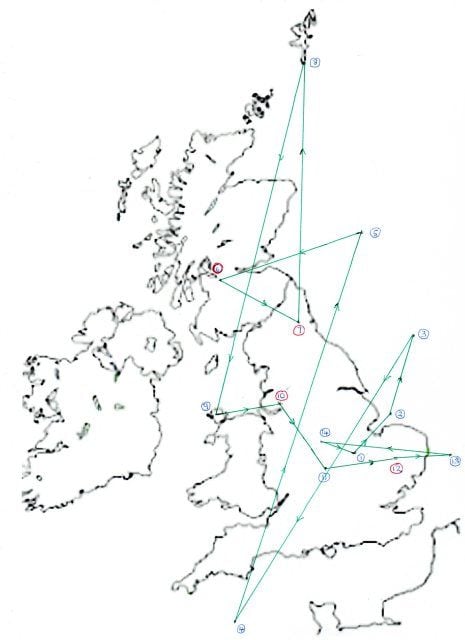
1. Wittering
2. 53.11N 00.32E North Sea off Skegness
3. 54.30N 01.20E Nr Dogger Bank off Whitby
4. 50.25N 04.08W Channel South of Plymouth
5. 56.32N 00.16E North Sea off Dundee
6. 55.52N 04.15W RBSU Glasgow
7. 54.58N 01.38W RBSU Gateshead
8. 60.52N 00.52W South Shetland
9. 53.12N 04.30W Anglesey
10. 53.26N 02.58W RBSU Liverpool
11. 52.15N 00.52W Northampton
12. 52.25N 00.45E RBSU Thetford
13. 52.32N 01.42E Channel off Lowestoft
14. 52.46N 01.12W Nr Loughborough
1. Wittering
Go to pdf pages 55-58.
For Valiant Profile Flight 12th August 1960, 7 Squadron, Honington.
p55 - Air Traffic Control Flight Plan
p56 - Briefing/De-Briefing Proforma
p57 - Loading Sheet
p58 - Flight Authorisation Book
p89 describes the nature of the flight as 'Training 'Profile' Flight consisting of two Navigation Stages, each of over 800 miles and 4 simulated bombing attacks against UK Radar Bomb Score Units. Crew briefed on type and duration of exercise to be carried out by 'A' Flight Commander who instructed them to 'self brief'. This is appropriate for this type of routine exercise'.
From the Air Traffic Control Flight Plan I put together a simple map of the route. As I'm no navigator it is probably inaccurate but it's an effort!
1. Wittering
2. 53.11N 00.32E North Sea off Skegness
3. 54.30N 01.20E Nr Dogger Bank off Whitby
4. 50.25N 04.08W Channel South of Plymouth
5. 56.32N 00.16E North Sea off Dundee
6. 55.52N 04.15W RBSU Glasgow
7. 54.58N 01.38W RBSU Gateshead
8. 60.52N 00.52W South Shetland
9. 53.12N 04.30W Anglesey
10. 53.26N 02.58W RBSU Liverpool
11. 52.15N 00.52W Northampton
12. 52.25N 00.45E RBSU Thetford
13. 52.32N 01.42E Channel off Lowestoft
14. 52.46N 01.12W Nr Loughborough
1. Wittering
I don't own this space under my name. I should have leased it while I still could
Hipper, I note the flight was a Training Profile Flight. On the Vulcan we had a 1500 Mile TPF. I under it to be Typical Profile Flight. This was usually a 600 mile primary navigation flight, a 200 mile low level and a 700 mile secondary stage. This was a Hi Lo Hi but we also did a longer flight which was called a Hi Lo Hi.
I note the RBSU mentioned were Glenrun, Rainbelt, Rubycorn and Brantub. These were code names for the scoring units at Abbotsinch (Glasgow Airport), Haydock, probably Ouston, and Methwold. By 1963 they had reverted to clear names, Glasgow, Haydock and Ouston. Methwold had closed. The RBSU for London was Kenley and that might have moved from Methwold.
I note the RBSU mentioned were Glenrun, Rainbelt, Rubycorn and Brantub. These were code names for the scoring units at Abbotsinch (Glasgow Airport), Haydock, probably Ouston, and Methwold. By 1963 they had reverted to clear names, Glasgow, Haydock and Ouston. Methwold had closed. The RBSU for London was Kenley and that might have moved from Methwold.
In the accident report posted by Hipper, on page 51 is the Flight Plan form. In Box N, beside MASTER GREEN is the code word EMBELLISH. What does that mean?

Thanks YS. I knew I had seen that before, but had forgotten what it meant. What's the equivalent for a deviating target?
I don't own this space under my name. I should have leased it while I still could
An embellished target was expected to maintain heading, height and speed.
When the V-Force still practised high level attacks against SAM defended targets we would fly an SAM evasive manoeuvre. Air defence fighters were not permitted to intercept the bombers within, I think, 50 miles, of their target in case the bomber began manoeuvring.
When I was at Eastern Radar(civil) in the 1980s,we would occasionally get a phone call from Neatishead,asking if a certain ASCOT VC10 that we were working over the North Sea,was willing to be 'embellished'? The pilots always readily agreed when asked.
