


Pre INS Long Range Nav Procedures?


Just a postscript to my earlier reply. Unfortunately I don't have all the details to hand some 40 years on but, when the NAT Track system was introduced, most (all?) civilian operators were then using Omega and/or multiple INS. There was a minimum equipment requirement as I recall and the MOD Air Staff had to get a specific exemption for RAF transport aircraft to fly these routes with a Nav, Doppler-based computers and Loran C. I did my last such VC10 flight from Dulles to Brize Norton on 3 April 1978, and I believe that the RAF's VC10s began to have Omega installed later that year.
short flights long nights
Ok, I have a question. Why did the Doppler stop working over calm water, as stated in an earlier post?

Doppler stopped when following the St Lawrence Seaway too, I think it was something to do with the calmer waters not reflecting enough signal back and acting like a mirror and reflecting the signal forward.
As a radio engineer I was once sent with a 707 MAN -YYZ with all the Doppler bits the company owned to keep it running in flight. We changed the external bits prior to departure and off we jolly well went.
I got the Doppler going just past the Irish coast and, with a minimal VOR fix off we went, Doppler, Loran A and the Nav. I was most impressed as the Nav did minimum correction and hit Gander on the nose. That's how I know about the seaway !
A quick spin in YYZ and back to LGW. The new nav was up and down like a yo-yo constantly making corrections. We were supposed to be coming in around BFS and then down to LGW. when the drivers eventually got a fix from an NDB we were missing by miles and heading to go round the top of Scotland. All ended well though. Grand times.
G-AYSL for those interested.
SOPS: Probably more than you need to know here - see under "Overwater Errors":
Avionics Navigation Systems - Myron Kayton, Walter R. Fried - Google Books
One night starting on a long flight direct from Travis AFB to Wake Island, the Doppler would not lock on properly at all .... until we had a rapid decompression on levelling at FL 350. Once things were sorted out with the aircraft heading back home we found it had locked on perfectly, so probably more a snag that needed a thump rather than an overwater thing!
Join Date: Mar 2010
Location: UK
Age: 76
Posts: 620
Likes: 0
Received 0 Likes
on
0 Posts
ICM
I believe that the twice daily NAT Track system was introduced in 1965, but perhaps one of our ATC friends could confirm this. When I was attempting to navigate a VC10 along these tracks in the late 60's and early 70's they were spaced 120nm apart (thankfully). The stricter nav equipment regulations came in when they moved to 60nm spacing. The BA VC10s were then fitted with INS to comply with these regulations.
My last flight as a navigator was on 3rd April 1975 (EGPK-KJFK)(G-ASGC) and we didn't have INS fitted at that time.
Pre anything
This is slightly off topic, and about much earlier times but a very good description of navigating over water from island to island is contained in a book by Francis Chichester, "The Lonely Sea and the Sky".
He was most famous for sailing single handed around the world, but in the 1920's he flew a Gipsy Moth from London to New Zealand, and made many solo flights across for example the Tasman sea. Two chapters describe the process, Landfall on a Pinpoint and the following one Wrecked. The book contains a reproduction of the chart Chichester plotted in the Gipsy Moth as he flew across the Tasman sea. Anyone interested in aviation should try to get hold of a copy of this book. Its fascinating, and gripping stuff.
He was most famous for sailing single handed around the world, but in the 1920's he flew a Gipsy Moth from London to New Zealand, and made many solo flights across for example the Tasman sea. Two chapters describe the process, Landfall on a Pinpoint and the following one Wrecked. The book contains a reproduction of the chart Chichester plotted in the Gipsy Moth as he flew across the Tasman sea. Anyone interested in aviation should try to get hold of a copy of this book. Its fascinating, and gripping stuff.
I was no NAV, but stationed at RAF China Bay (Ceylon) in 1957 I made a couple of trips in 205/209's Sunderlands from Seletar to China Bay via Penang.
As pointed out to me at the time by the NAV, once we'd passed the northern tip of Sumatra he turned west and tuned in to the China Bay NDB and followed the needle all the way across the Indian Ocean to China Bay.
The China Bay NDB was a powerful piece of kit, 15kW ISTR and highly praised by the navigators of the various RAF aircraft that transited the Indian Ocean/Bay of Bengal.
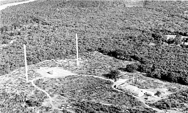
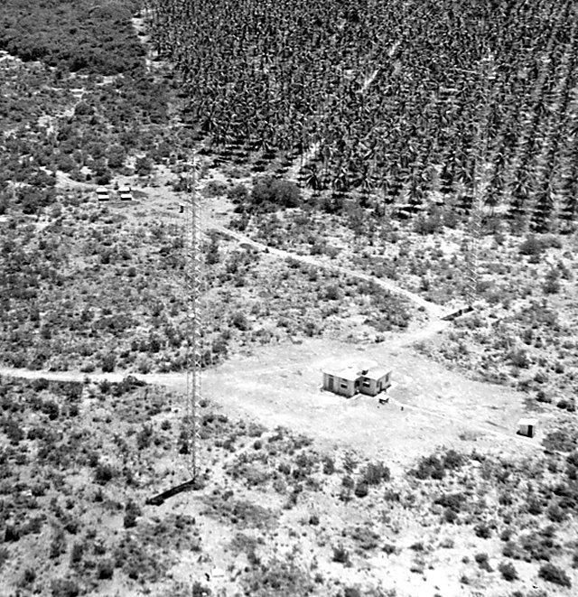
FWIW here's what the China Bay NDB looked like from the air in 1957. Two 220ft high radio masts with the aerial elements strung between them.
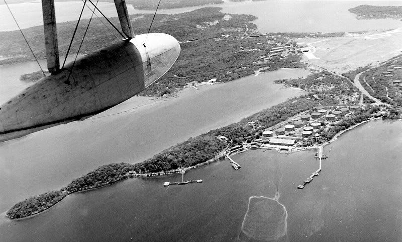
...and here's a Sunderland arriving safe and sound at China Bay.
As pointed out to me at the time by the NAV, once we'd passed the northern tip of Sumatra he turned west and tuned in to the China Bay NDB and followed the needle all the way across the Indian Ocean to China Bay.
The China Bay NDB was a powerful piece of kit, 15kW ISTR and highly praised by the navigators of the various RAF aircraft that transited the Indian Ocean/Bay of Bengal.
FWIW here's what the China Bay NDB looked like from the air in 1957. Two 220ft high radio masts with the aerial elements strung between them.
...and here's a Sunderland arriving safe and sound at China Bay.
Long ago I read that from halfway across the Atlantic you could get to within 100 miles of London by homing in on the BBC Long Wave 198 khz signal, which comes from Droitwich.
True ?
True ?
Well, despite having 3 Litton 72R INSs in my DC-10 with Laker, I always had the ADFs tuned to 600 kcs westbound across the Atlantic and 200 kcs eastbound.
The first one was a radio station somewhere in Labrador and the other was Daventry (198 kcs).
Either one would at least help you to avoid missing Canada or UK.
Finesse could come later!
The first one was a radio station somewhere in Labrador and the other was Daventry (198 kcs).
Either one would at least help you to avoid missing Canada or UK.
Finesse could come later!
Join Date: Nov 2007
Location: New Zealand
Age: 77
Posts: 519
Likes: 0
Received 0 Likes
on
0 Posts
I was a passenger on an Air NZ DC8 1975 (or so) Rarotonga to Fiji. I was on my way to a posting at Hannan International, Niue which was one of the waypoints.
They did a slight turn to left, then right so the passengers could see the island and I was quite interested too as it was my first glimpse of a small green island marked by little more than the areas of blazing white coral runway surrounding the black runway.
As far as I could tell they were homing on the Niue NDB and when overhead flicked a couple of switches for their new course to Nandi. I do not know if they were then homing on Nandi or flying on a stern bearing from Niue.
Join Date: Jul 2003
Location: Austin, Texas, USA
Posts: 55
Likes: 0
Received 0 Likes
on
0 Posts
I was a USAF student navigator in 1975. I recall the instructors telling us that the last civilian airline navigator in the U.S. had just retired from Flying Tiger.
We did learn day and night celestial, use of drift meters, grid navigation, doppler, radar navigation, plotting Loran fixes using time delay lines, pressure navigation, and CONSOLAN.
And a bunch of other stuff I can't recall.
I went into fighters, but when I got deployed in a trash hauler I always asked the nav if I could take a cel shot, and usually they'd let me.
Celestial nav is kinda cool.
Join Date: Nov 2007
Location: New Zealand
Age: 77
Posts: 519
Likes: 0
Received 0 Likes
on
0 Posts
I studied for a nautical 'Master, Ocean Going' for small ships in the mid 70's. This was after I had crossed the Pacific on a small sloop using the tables for celestial sight reduction but for that course we had to use the haversine method. Haversine "half the inverse of the sine" if I recall correctly. As far as I remember it was a brilliant processs (maybe invented by Bowditch?) which enabled a sight to be completely calculated by processes of addition only. However I never got to go deep water sailing again and never used the skill.
Join Date: Mar 2007
Location: USofA
Posts: 1,235
Likes: 0
Received 0 Likes
on
0 Posts
Pre 1965
One last reference for those still interested.
B707 Without INS - How Did They Navigate? � Tech Ops Forum | Airliners.net
B707 Without INS - How Did They Navigate? � Tech Ops Forum | Airliners.net
