


R-19 Nordhausen Advanced Landing Ground, WWII

Thread Starter
Join Date: Dec 2011
Location: Des Moines, Washington USA
Posts: 4
Likes: 0
Received 0 Likes
on
0 Posts
R-19 Nordhausen Advanced Landing Ground, WWII
I am looking for the location of R-19 advanced landing ground (ALG) at Nordhausen, Germany. I have the history and daily diaries of the 438th Troop Carrier Group for WWII. There is no mention of the actual location of the ALG other than they went to R-19 at Nordhausen to ferry french forced laborers. I have looked up the Airfield number in the "U.S. Army Air Forces Continental Airfields (ETO) D-Day to V-E Day" report but there is only the city location mentioned. Does anyone have Google map coordinates for this ALG? Does anyone know where I could find information that would give me the physical location (longitude/latitude) of this airfield?
Thanks for your help.
Patricia
Thanks for your help.
Patricia

R-19 was probably sited on the eastern outskirts of Nordhausen town. Google Earth shows a grass light aircraft strip in this position. In 1945 it was probably much larger and a metal (PSP) runway may have been laid for the C-47s, as well as taxiways and parking areas.
Thread Starter
Join Date: Dec 2011
Location: Des Moines, Washington USA
Posts: 4
Likes: 0
Received 0 Likes
on
0 Posts
I saw an airfield and looked it up. It is a glider field if my German translator is correct. I was not sure if that was the same field as the Army Air Force used.
I cannot find when that field was established. The glider club has a website maybe they will have some history if I can get through the German. What does
ICAO: EDAO stand for?
AIRPORT Flughafen Flugplatz Pilot
I cannot find when that field was established. The glider club has a website maybe they will have some history if I can get through the German. What does
ICAO: EDAO stand for?
AIRPORT Flughafen Flugplatz Pilot
Join Date: Feb 2006
Location: Chessington, Surrey
Age: 76
Posts: 419
Likes: 0
Received 0 Likes
on
0 Posts
ICAO EDAO is the location indicator for Nordhausen AP. ED.. refers to Germany just as EG.. denotes an airfield in the UK.
Try entering the lat/lon 51'29.45.45N, 10'50.20.02.E into Google Earth.
The link is at that point on Google Earth
Ciarain.
Just tried the lat/lon on Google Earth-no luck.
Try entering the lat/lon 51'29.45.45N, 10'50.20.02.E into Google Earth.
The link is at that point on Google Earth
Ciarain.
Just tried the lat/lon on Google Earth-no luck.
Join Date: Feb 2006
Location: Chessington, Surrey
Age: 76
Posts: 419
Likes: 0
Received 0 Likes
on
0 Posts
Flugplatz Nordhausen
By LarryC1
This little grass strip airfield has quite a history! I believe that it was a Zeppelin field during World War One, although I have been unable to confirm this. During World War Two it was bombed as a 'target of opportunity' by 11 B-17's. After the liberation of nearby Mittelbaau-Dora it saw ex-prisoners fed here and then flown out in DC-3's to their homes. It would now appear to be a sail-plane field. Peace at last!
Flugplatz Nordhausen - 0 Messages
 Google Earth CommunityAbove is the link I mentioned, put "Nordhausen" into Google Earth. Move slowly east, a large field can be seen.
Ciarain.
A quick edit and question: is it possible to put a Google Earth Placemark on Pprune?
By LarryC1
This little grass strip airfield has quite a history! I believe that it was a Zeppelin field during World War One, although I have been unable to confirm this. During World War Two it was bombed as a 'target of opportunity' by 11 B-17's. After the liberation of nearby Mittelbaau-Dora it saw ex-prisoners fed here and then flown out in DC-3's to their homes. It would now appear to be a sail-plane field. Peace at last!
Flugplatz Nordhausen - 0 Messages
Ciarain.
A quick edit and question: is it possible to put a Google Earth Placemark on Pprune?
Last edited by Kieron Kirk; 24th Mar 2012 at 12:30.
Join Date: Feb 2006
Location: Chessington, Surrey
Age: 76
Posts: 419
Likes: 0
Received 0 Likes
on
0 Posts
Follow the road L3080 out of Nordhausen, east and slightly south. Just before the village of Bielen, on the left is the airfield. Go in close, a glider is visible.
Ciarain.
Ciarain.
Join Date: Dec 2011
Location: herts
Posts: 1,838
Likes: 0
Received 0 Likes
on
0 Posts
This page [HS] Nordhausen - Die Ausbildung zum Hubschrauberf�hrer der NVA. Ich hab's erlebt. shows Flugplatz Nordhausen to be located south of the town just below the railway, and it looks like the buildings at 51�29'18.28 N 10�47'18.74 E are the buildings left centre of the phote below - larger version in the link above. There is a helicopter in the middle of the buildings on GE.
I've got a photo of Nordhausen at the end of the war which I'll post when I get home this evening.
I've got a photo of Nordhausen at the end of the war which I'll post when I get home this evening.
Join Date: Dec 2011
Location: herts
Posts: 1,838
Likes: 0
Received 0 Likes
on
0 Posts
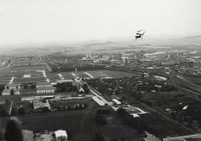
Nordhausen Flugplaz 12th May 1945

There is the airfield at the 40 second point in this film from 4th April 1945 http://www.bomber-command.de/ndh.mpg the following couple of seconds seem to indicate south of the railway track again (assuming looking north in the video)
This page has the following image showing that the Flugplatz until 1945 was to the south.
Thread Starter
Join Date: Dec 2011
Location: Des Moines, Washington USA
Posts: 4
Likes: 0
Received 0 Likes
on
0 Posts
Oh my Gosh! You all have been wonderful with information. Thanks so much for the picture. the directions will really help. I am visiting the area around the 20th of April. I am putting together a family book about my father's WWII history. After the VE day he flew C-47s to pickup French laborers from Nordhausen. May I use the pictures in my book? Are they in public domain? Do you have any pictures of C-47s and the laborers on the ground? Thanks again for confirming the location of the airfield. One veteran from the same Troop Carrier Group as my dad, 438th, told me, the first time he went to pickup laborers, how hard it was to watch the laborers get into the planes and then when they got them to an airfield outside of Paris many of them tried to stand and salute while the French anthem was played. He said it was so sad to see. I am so grateful for this information.
Warmest Regards!
Patricia
Warmest Regards!
Patricia
