


Can anyone help, where is this airfield?

Thread Starter
Join Date: Jun 2004
Location: Suffolk
Age: 47
Posts: 243
Likes: 0
Received 0 Likes
on
0 Posts
Can anyone help, where is this airfield?
Does anyone have any idea where this is? It was suggested on this thread on the AiX forum to post the photo here too as you guys maybe may be able to help!

I think it is somewhere in Europe but really have no idea whatsoever! Any help is greatly appreciated.
Cheers
I think it is somewhere in Europe but really have no idea whatsoever! Any help is greatly appreciated.
Cheers
Last edited by REF; 24th Mar 2010 at 23:25.

But it did...
...... in 1945, when the photo was taken.
The view is looking east towards Rendlesham Forest and the airfield map in 'British Military Airfields of WWII' confirms the 'footprint'.
O-D
The view is looking east towards Rendlesham Forest and the airfield map in 'British Military Airfields of WWII' confirms the 'footprint'.
O-D
Woodbridge post modification had a 450ft wide paved surface
Old-Duffer:
"In 1942 the bomber offensive was assuming massive proportions, and it was decided to build three airfields specifically to accommodate aircraft which were damaged, short of fuel or suffering from undercarriage or brake trouble. A crash landing on an airfield to which others were returning could be fatal. So could a return if fog descended on the operating stations. All these factors led to the construction of three specialised airfields, at Carnaby, Manston and Woodbridge, of which the latter proved to be the busiest by day and night.
These three airfields were sited along the East Coast so that crippled bombers could land immediately after crossing the coast. Each had a runway 3,000 yards long and 250 yards wide with an undershoot and an overshoot at each end of 500 yards. The runway at each was laterally divided into three lanes. The south lane lined with green lights at night, white by day, was the emergency lane into which any aircraft could land without first contacting flying control. The centre lane was lined by white lines at night, the northern by yellow. By day the lines of lights clearly defined the three sections of the runway".
So, if we are to believe you, the extra wide runway laid in 1942 was dug up again and camouflaged when the photograph was taken "in 1945" and then susequently re-layed before I got there when I was driving aircraft for Mrs Windsor in the 1960s.
I remember the Woodbridge runway just as it is shown on Google Earth (just like Manston).
Sorry Sir; not Woodbridge.
I would bet on it being a Soviet Bloc airfield.
Join Date: Apr 2008
Location: UK
Age: 69
Posts: 158
Likes: 0
Received 0 Likes
on
0 Posts
Judging by the landscape its northern europe. And judging by the fully leafed trees, summer (ish). Long shadows say early morning or late evening and lead me to think its approx a 06/24 or 07/25 runway alignment.....
Not sure this helps though. That might be one too many assumptions .....
Not sure this helps though. That might be one too many assumptions .....
Thread Starter
Join Date: Jun 2004
Location: Suffolk
Age: 47
Posts: 243
Likes: 0
Received 0 Likes
on
0 Posts
Thanks for the help so far folks, I can't find anything to say it is Woodbridge, all the RSP's and other sources I have show a different layout. Also the proximity to the houses at the left of the photo, just above the airfield would say it is definitely not Woodbridge.
My thoughts are it is in Europe somewhere.
My thoughts are it is in Europe somewhere.


Join Date: Jul 1999
Location: 58-33N. 00-18W. Peterborough UK
Posts: 3,040
Likes: 0
Received 0 Likes
on
0 Posts
Looks like Slovakia.
 What we need is a proven aerial shot of Sliac prior to the mid fifties, when it was called Tri Duby. Quite a famous field.
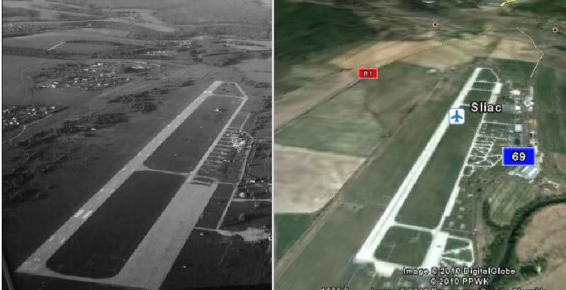
Last edited by forget; 16th Mar 2010 at 16:28. Reason: Added Pic
Thread Starter
Join Date: Jun 2004
Location: Suffolk
Age: 47
Posts: 243
Likes: 0
Received 0 Likes
on
0 Posts
The landscape isn't convincing me on that, the woods at the approach to the runway and the landscape on the left of the photo is different to what shows in google.
The runway orientation is wrong too.
I do think it is an eastern block airfield though.
The runway orientation is wrong too.
I do think it is an eastern block airfield though.
Definitely not Carnaby which, like Woodbridge and Manston, was developed with a triple width paved surface ie 450ft minimum.
In some ways, it resembles Greenham Common, but I don't think it's anywhere in the UK.
In some ways, it resembles Greenham Common, but I don't think it's anywhere in the UK.
Join Date: Jan 2003
Location: Surrey Hills
Posts: 1,478
Likes: 0
Received 0 Likes
on
0 Posts
If not Slovakia then the Czech Republic maybe? I looked at nearly all the Slovak ones and none really fit that well. Sliac is so nearly there but the surrounding landscape doesn't quite fit.
A quick look into Czech airfields was promising but still no Bingo! effect. Dofrany nearly did though.
A quick look into Czech airfields was promising but still no Bingo! effect. Dofrany nearly did though.