


Abandoned & Little-Known Airfields

An extensive list of UK airfields can be found here:
http://fly.dsc.net/u/Home
I found it looking for the old Cardiff Airport at Pengam Moors. I used to go kart racing there in the early 60's when, I believe, it was owned by the Rover company and there was little evidence of it ever having been an airfield.
http://fly.dsc.net/u/Home
I found it looking for the old Cardiff Airport at Pengam Moors. I used to go kart racing there in the early 60's when, I believe, it was owned by the Rover company and there was little evidence of it ever having been an airfield.

Join Date: Aug 2000
Posts: 146
Likes: 0
Received 0 Likes
on
0 Posts
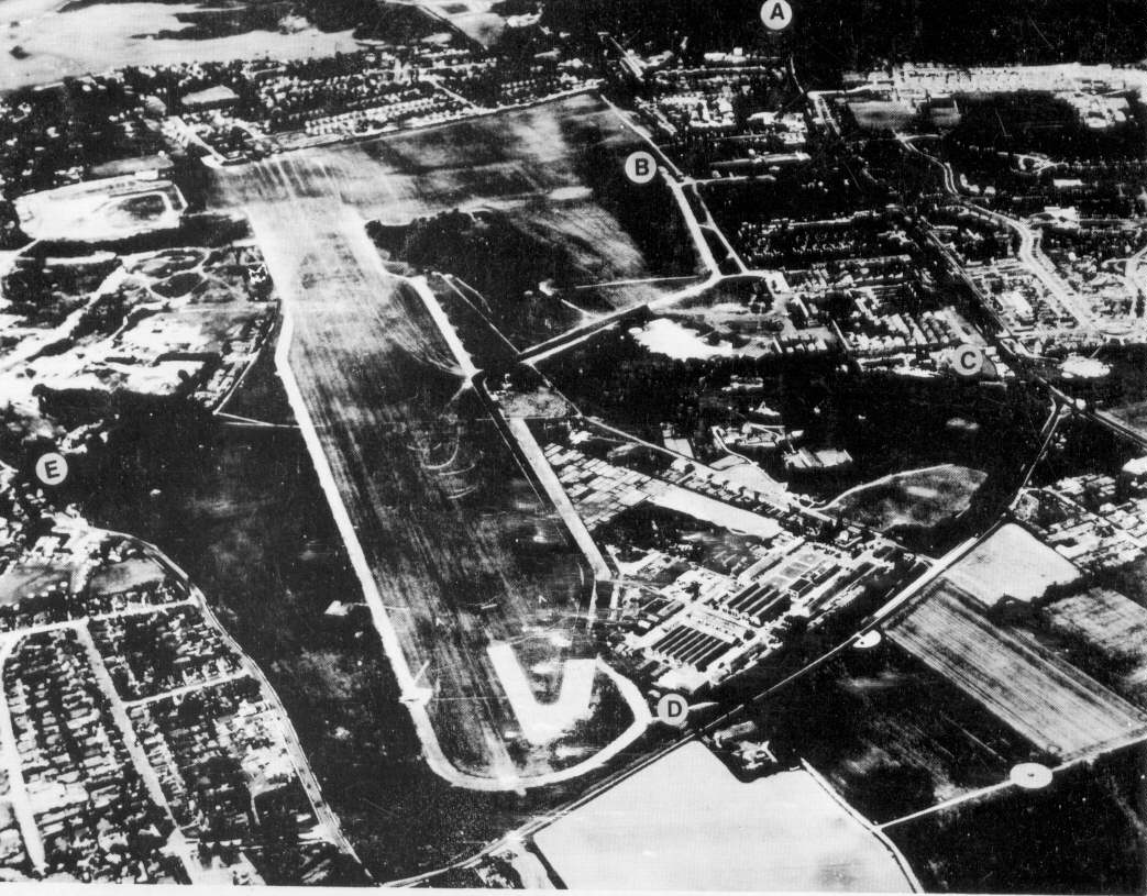
Grow45: those look suspiciously like hangars on the Abbotsinch Road?
Compare with Luftwaffe photo of Grangemouth, labelled 'A'.
http://www.rcahms.gov.uk/images/445486.jpg
Compare with Luftwaffe photo of Grangemouth, labelled 'A'.
http://www.rcahms.gov.uk/images/445486.jpg
Join Date: Jan 2005
Location: France
Posts: 2,315
Likes: 0
Received 0 Likes
on
0 Posts
Sorry, visibility3miles....
You mentioned airfields in the US, and all you get is airfields in the UK.....
One more....
I bought this ages ago, and it still makes interesting reading.
Freeman, Roger A., Airfields Of The Eighth, Then And Now, 1978
You mentioned airfields in the US, and all you get is airfields in the UK.....
One more....
I bought this ages ago, and it still makes interesting reading.
Freeman, Roger A., Airfields Of The Eighth, Then And Now, 1978
Join Date: Oct 2002
Location: Scotland
Posts: 168
Likes: 0
Received 0 Likes
on
0 Posts
gbh said
"Grow45: those look suspiciously like hangars on the Abbotsinch Road?
Compare with Luftwaffe photo of Grangemouth, labelled 'A'.
http://www.rcahms.gov.uk/images/445486.jpg"
Interesting - I had assumed they were modern but they look in exactly the right position. I'll maybe take a look next time I am passing.
Loki said
"Just had a look at Google Earth, and there doesn`t seem to be much evidence of an airfield any more at Renfrew."
Is the long straight stretch of the M8 not on the line of the old runway. Not immediately obvious as part of an airfield but interesting as a reminder of where it was.
g45
Join Date: Mar 2000
Location: On a radial
Posts: 361
Likes: 0
Received 0 Likes
on
0 Posts
As said earlier, hatfield is changing VERY quickly, good that the tower and the Trident shed remain though  Nice big clue. One of the best street names i've seen there is "the Runway" what a nice address that would be!
Went to brooklands last year, very hard to imagine an airfield once being there, and also what about Christchurch airfield in dorset?
Apparently there was once a sea vixen on concrete blocks. The blocks remain sat outside PCworld but no aircraft.... any ideas where that airframe ended up?
81
edit:
just found these pics of christchurch.... is the BAe site at Mudeford, or is it where i am thinking behind pcworld now??
Nice big clue. One of the best street names i've seen there is "the Runway" what a nice address that would be!Went to brooklands last year, very hard to imagine an airfield once being there, and also what about Christchurch airfield in dorset?
Apparently there was once a sea vixen on concrete blocks. The blocks remain sat outside PCworld but no aircraft.... any ideas where that airframe ended up?
81
edit:
just found these pics of christchurch.... is the BAe site at Mudeford, or is it where i am thinking behind pcworld now??
Join Date: Mar 2001
Location: Asgard
Posts: 488
Likes: 0
Received 0 Likes
on
0 Posts
Grow 45 re Renfrew
Yes, I believe you may be right, the M8 is alleged to follow the centreline exactly. I remember driving on said motorway in the very early 70s and the old control tower could be seen from the road; the rest of the site to the north becoming a housing estate. On the other side of the motorway, was the Rolls Royce site (Hillington), the buildings of which certainly looked like they belonged at an airfield.
Yes, I believe you may be right, the M8 is alleged to follow the centreline exactly. I remember driving on said motorway in the very early 70s and the old control tower could be seen from the road; the rest of the site to the north becoming a housing estate. On the other side of the motorway, was the Rolls Royce site (Hillington), the buildings of which certainly looked like they belonged at an airfield.
Bear Behind
There's not a lot left of Woodley Airfield on the edge of Reading, where Miles Aircraft used to be based. There's a bit of a museum and the road names around have been given an aviation flavour but the airfield itself is long gone.
Join Date: Feb 2006
Location: EGYT
Posts: 46
Likes: 0
Received 0 Likes
on
0 Posts
The runway at Tangmere was dug up a few years ago. All that appears to remain are the old control tower building and the excellent museum. I think part of the airfield has been developed into industrial units/warehousing, etc.
It is still possible to see where the runways once were.
It is still possible to see where the runways once were.
sua cuique voluptas
Fairlop (ex Spitfire base), East London, runways gone for hardcore and then totally obliterated by years of gravel extraction. I was brought up on the other side of the Central Line and well remember playing amongst the tank traps and pill boxes in the 50's....
Witney, Oxon. Possible to trace the the layout via the industrial estate. Visiting the JR hospital recently and met an old lady who worked in the de Havilland repair shop during the war. She had some nice tales to tell!
Harrington, near Sywell, is a more traceable site with an impressive covert history from the US Carpetbaggers operations (RAF Tempsford nearby was the UK equivalent) to the Thor missile site operations of the Cold War. Google Earth shows the remains of the missile launch platforms. The museums there are both well worth a visit. See http://harringtonmuseum.org.uk/Location.htm
There's a small memorial to a wartime Spit pilot who dropped in for lunch and the chocolate that the Americans had, put on "a show" for the Yanks and departed low and barrel rolled it into the Admin hut. Also parked outside is a blue T6 that seems to have been abandoned by it's owner (visible on Google, the Harvard, not the owner...)
Nothing much left of Twinwood Farm north of Bedford now. I landed there years ago as part of my gliding Silver C. Runways totally gone, but the peri track shows where it was, now just a ghost in the fields. That's where Glen Miller took off from on his last, fatal flight.
Hope this interests
Ripline
More than just an ATCO
Join Date: Jul 1999
Location: Up someone's nose
Age: 75
Posts: 1,768
Likes: 0
Received 0 Likes
on
0 Posts
Folkestone, on the racecourse. The only thing I could see was the Airport Cafe on the A20.
Donibristle, in Fife. Is there anything left of Hamble? Barton (Beds.) once had a grass airfield i was told but never found traces
Donibristle, in Fife. Is there anything left of Hamble? Barton (Beds.) once had a grass airfield i was told but never found traces
Lon; you can't see much of Hawkinge any more either.
Another one I looked at on Flashearth is Molesworth; completely obliterated by cruise missile bunkers.
Barton-in-the Clay, Luton's first airport, still has traces in the old buildings now an industrial estate.
Another one I looked at on Flashearth is Molesworth; completely obliterated by cruise missile bunkers.
Barton-in-the Clay, Luton's first airport, still has traces in the old buildings now an industrial estate.

More than just an ATCO
Join Date: Jul 1999
Location: Up someone's nose
Age: 75
Posts: 1,768
Likes: 0
Received 0 Likes
on
0 Posts
At Hawkinge there is still the BoB Museum, the camp cinema remains as do most of the accommodation, albeit i a very bad condition. The runways have disappeared under new houses, many of the street names are not even aviation related (PC gone crazy)
Barton le Clay. The first time i heard of it's existence was during an interview at Hamble. Ii must have overflown it many times and even looked on the ground but could find nothing. Not the best place for an airfield, with sharply rising ground on three sides.
Here is a lot of info and links to many other sites
Fly is probably well known to readers, but included an aerial view of the site of Barton, also another one as Luton Leagrave. I've never heard of that one either and the position shown is well outside Leagrave, nearer Dunstable.
Last edited by Lon More; 1st Jun 2007 at 09:11.
Up in Buckinghamshire, near the border with Herts travelling from Chesham to Berkhamstead, about 1/2 mile before you get to the village of Ashley Green to the west of the main road there's a small field containing a 'blister' type hangar. I say type because all the years I've seen it (since mid '50s) it's been re-roofed and refurbished so that although it's still the correct shape, I doubt if there's much original material left!
My parents always said it was an airfield that they started to build but never finished (it's about 2 or 3 miles west of Bovingdon) but the field looks too small to be a real airfield. Maybe it was a temporary strip used in the run-up to D-Day?
Returning to the south coast, as well as Hawkinge, Hastings (Pebsham) and Bexhill (Siddeley Green) have also been obliterated by housing.
Last edited by chevvron; 2nd Jun 2007 at 18:53.
Join Date: Apr 2007
Location: UK
Posts: 81
Likes: 0
Received 0 Likes
on
0 Posts
Don't know if this counts as there were only ever hard runways at the ends (although the peri track was concrete all the way round) - try Croydon Airport - hard end of runway adjacent to A23 still visible - the rest largely under houses flats all with aviation related road names
For those looking in the Norfolk area the following URL might be useful - it enables you to compare aerial photographs of 1988 & 1946 for most areas.
www.historic-maps.norfolk.gov.uk/Emap/EmapExplorer.asp
www.historic-maps.norfolk.gov.uk/Emap/EmapExplorer.asp