


Wittering 5 mile runway -- is it true?


Join Date: Mar 2006
Location: Just south of the Keevil gap.
Posts: 308
Likes: 0
Received 0 Likes
on
0 Posts
Elvington, near York, has 10,152 ft of runway plus 49 acres of concrete hardstanding. The display at the YAM claims it is visible from the Space Shuttle , so should be a good spot on Google earth.

Join Date: Aug 1999
Location: U.K.
Posts: 459
Likes: 0
Received 0 Likes
on
0 Posts
 When gliding at Sharjah in the sixties, we auto-towed with a Nissan Patrol using commercial fencing wire pulling the T21 up to 2000ft, which used up about 5 miles of bundoo. Does that count?
from:http://www.ageconcern.org.uk/TimeCap...0577E49E63.htm
So I came to find myself at Little Staunton, near St.Neots, which was a Pathfinder Force bomber station and where, in addition to almost daily trips on test flights in Lancasters following their servicing or repair, we worked in the bomb bay assisting with the bombing up of aircraft before they flew off on raids.
This was found via a web search, maybe I should have looked on http://www.controltowers.co.uk/L/LittleStaughton.htm, eitherway, Wittering could not have had a 5 mile strip.
Join Date: May 2001
Location: up North
Posts: 661
Likes: 0
Received 0 Likes
on
0 Posts
Checking a further source shows that the July 1944 published runway length for Wittering was 5020yds - 15060ft - 2.48nm - 2.85st.m.
As mentioned earlier a five mile runway plan was under study for Bedford although it may be that other airfields were earmarked for similar development.
As mentioned earlier a five mile runway plan was under study for Bedford although it may be that other airfields were earmarked for similar development.

Join Date: Jul 1999
Location: 58-33N. 00-18W. Peterborough UK
Posts: 3,040
Likes: 0
Received 0 Likes
on
0 Posts
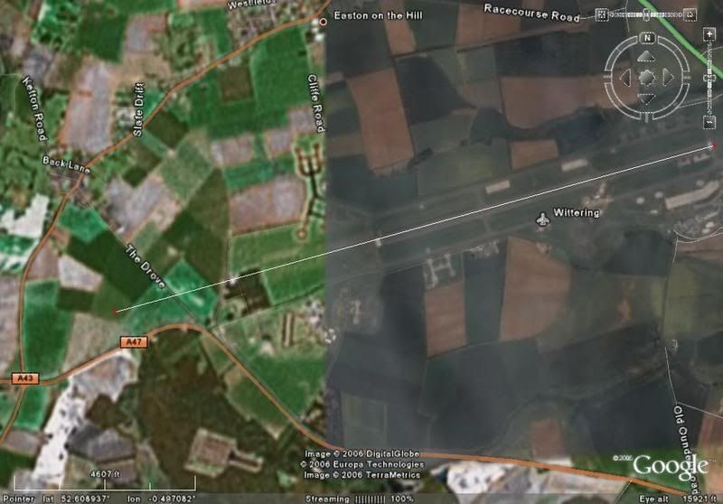
I think it very unlikely that Wittering ever had a five mile strip, grass or otherwise. The A43 is the limiting factor. Not just because it's always been a major road but, immediately west of the A43, the land drops into a valley. Three miles shown here. The road at top right is the A1.
Last edited by forget; 29th Nov 2006 at 10:11. Reason: typo
Gentleman Aviator
Elvington, near York, has 10,152 ft of runway
There were I believe, two plans for RAE Bedford, the aforementioned one of joining it to Little Staughton, and another joining it to Twinwoods Farm. The latter obviously got off the ground initially, hence the fact that the road just south of the old main gate at Thurleigh was routed through a cutting which the runway would then have been built over. I believe that's as far as it got though.
By the way, re Elvington; there were at least 8 runways of 10,000ft available for Conc; several were built for the SAC mission in the late '50s including Elvington, Bruntingthorpe, Fairford and Brize. I think Chelveston may have been another.
By the way, re Elvington; there were at least 8 runways of 10,000ft available for Conc; several were built for the SAC mission in the late '50s including Elvington, Bruntingthorpe, Fairford and Brize. I think Chelveston may have been another.
Red On, Green On
Join Date: May 2004
Location: Between the woods and the water
Age: 24
Posts: 6,487
Likes: 0
Received 2 Likes
on
2 Posts
Manston, before defence cuts, had a foam facility for aircraft without gear, there was another airfield also, I recall it may have been Leeming, that had foam.
Looking at the aerial photograph and the OS map above you might think that the A47 has been diverted round a possible runway extension from the minor road The Drove. However I have a 1939 UK road atlas which shows that the road layout there was just the same pre-war, although it has been realigned both east and west of this point. The map also shows the minor roads which did once cross the ground where the Wittering runway is now, so pre-dates the construction of the field.
Here's a better view - click on the dark panel to make it disappear.
http://www.flashearth.com/?lat=52.60....2&r=0&src=msl
BTW - Look at the facilty just south of the A47.
Some former V bomber stations have a similar feature (Waddington, Honington) but others don't (Cottesmore, Scampton). I guess it's a bomb-dump but it's not like the grassed over bunkers found on all V-Force stations. Any thoughts?
Join Date: Nov 2006
Location: West Yorkshire Zone
Posts: 976
Likes: 0
Received 0 Likes
on
0 Posts
What if any - are the Future plans for Wittering?
There is only 1 Harrier OCU SQN based there now, after 1/3/4 SQN's moved up the road to Cottesmore.
I pressume Wittering is the Relief Landing ground for Cottesmore.
I have passed the main entrance a few times, and the entrance is about 50ft from the A1!!
Regards.
There is only 1 Harrier OCU SQN based there now, after 1/3/4 SQN's moved up the road to Cottesmore.
I pressume Wittering is the Relief Landing ground for Cottesmore.
I have passed the main entrance a few times, and the entrance is about 50ft from the A1!!
Regards.
I was there for ATC camp back in '87. We did a NITEX in those woods just north of the A47 in line with the runway; there was a Hastings parked there then. We accessed this area along the perimeter airfield road; there is a public road parallel to part of the boundary (more like a cart track when I was there) but I did see the police interviewing people who stopped there.
The site mentioned south of the A47 definitely looks like a bomb dump to me.
If you move the map to 52. 42 N 000.34 W you will see the disused airfield of Woolfox Lodge, with the Bloohound Missile pads clearly visible; built to protect the Thor ICBMs at North Luffenham.
The site mentioned south of the A47 definitely looks like a bomb dump to me.
If you move the map to 52. 42 N 000.34 W you will see the disused airfield of Woolfox Lodge, with the Bloohound Missile pads clearly visible; built to protect the Thor ICBMs at North Luffenham.
Join Date: Jul 1999
Location: 58-33N. 00-18W. Peterborough UK
Posts: 3,040
Likes: 0
Received 0 Likes
on
0 Posts
 quarry/landfill.
Yes, Him
Join Date: Aug 1999
Location: West Sussex, UK
Posts: 2,689
Likes: 0
Received 0 Likes
on
0 Posts
It is a bomb dump, or it was when I was stationed there.
Twas full of 1,000lb ers. The other, covered over, bomb dump, just to the south west of the runway is (or was) the RAF Armament Support Unit for servicing nuke warheads.
Twas full of 1,000lb ers. The other, covered over, bomb dump, just to the south west of the runway is (or was) the RAF Armament Support Unit for servicing nuke warheads.
Join Date: Jul 1999
Location: 58-33N. 00-18W. Peterborough UK
Posts: 3,040
Likes: 0
Received 0 Likes
on
0 Posts
Ooops. We're talking two different things here Gainsey. Thing you're talking about - bomb dump.
http://www.flashearth.com/?lat=52.59....3&r=0&src=msl
Thing I'm talking about - quarry.
http://www.flashearth.com/?lat=52.59....9&r=0&src=msl

http://www.flashearth.com/?lat=52.59....3&r=0&src=msl
Thing I'm talking about - quarry.
http://www.flashearth.com/?lat=52.59....9&r=0&src=msl