


Piper PA32 aircraft. Kananaskis Country, Alberta Canada.

Thread Starter
Piper PA32 aircraft. Kananaskis Country, Alberta Canada.
CBC Calgary are reporting the lose of 6 individuals with the crash of a Piper PA32.
https://www.cbc.ca/news/canada/calgary/plane-crash-kananaskis-village-1.6922315
https://www.cbc.ca/news/canada/calgary/plane-crash-kananaskis-village-1.6922315

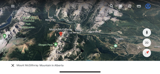
The aircraft took off from Springbank Airport, west of Calgary about 9pm and crashed about 35 nm from Springbank just inside the Rocky Mountain Front Ranges. Sunset at Banff was 9:35 pm, so it would still have been light at the time of the crash.
The aircraft crashed on the slopes of Mt. Bogart (10,315'):

The destination was Salmon Arm, 186 nm from Springbank, so most of the flight would have been in the dark over high mountains. Not something I would care to plan.
The aircraft crashed on the slopes of Mt. Bogart (10,315'):
The destination was Salmon Arm, 186 nm from Springbank, so most of the flight would have been in the dark over high mountains. Not something I would care to plan.
Moderator
I flew eastbound south of that route in May. It is not a route I would fly at night in a single at all, and I would really have to think about taking six people with me in a single on that route even in good conditions. Different pilots make different choices, that's a choice I would not have made...

More news links here: Accident Piper PA-32 , 28 Jul 2023 (aviation-safety.net)
Can't find the registration number anywhere, but if it was indeed a straight PA32 (not turbo), like Pilot Dar says above, 6 people, impending darkness, mountains, not a good situation.
RIP
Can't find the registration number anywhere, but if it was indeed a straight PA32 (not turbo), like Pilot Dar says above, 6 people, impending darkness, mountains, not a good situation.
RIP
Useful load is 1600-ish, almost 1000lbs with full fuel.
Six adults @ 180 lbs = 1080
Six adults @ 200 lbs = 1200
Luggage 30lbs x 6 = 180 lbs
1260-1380, depending on the fuel load that aircraft could have been close to max if not a little over.
I don�t know if the �6� has a difficult weight & balance envelope.
I do remember on the Seneca 1 which is basically a Cherokee 6 with two engines that the rear seats could only hold two kids as the CG would be out of range.
Its been a while but doesn�t the 6 have 4 twenty gallon tanks that require a lot of switching ?
A single engine piston at max weight in night IMC�.in mountainous terrain.
Density altitude would have been in the 12,000� range Calgary being ISA+7.
That�s just not a good combination.
Last edited by B2N2; 31st Jul 2023 at 17:23.
Luggage may have been light since they went for a church event so possibly returning the next day. Still with enough fuel that plane would have been heavy and struggling with the density altitude.
The aircraft took off from Springbank Airport, west of Calgary about 9pm and crashed about 35 nm from Springbank just inside the Rocky Mountain Front Ranges. Sunset at Banff was 9:35 pm, so it would still have been light at the time of the crash.
The aircraft crashed on the slopes of Mt. Bogart (10,315').
The destination was Salmon Arm, 186 nm from Springbank, so most of the flight would have been in the dark over high mountains. Not something I would care to plan.
The aircraft crashed on the slopes of Mt. Bogart (10,315').
The destination was Salmon Arm, 186 nm from Springbank, so most of the flight would have been in the dark over high mountains. Not something I would care to plan.
It was a Lance, reg C-FCCY.
It would be interesting to know the winds at mountain top level. Turbulence, rotor and wave are possibilities. The weather modelling people may be able to give us an idea on the winds.
Heavy sink downwind of a ridge can exceed climb capability.
Heavy sink downwind of a ridge can exceed climb capability.
The crash location makes me suspect that the pilot might have been following the VFR Route, which follows Trans Canada Highway 1.
I’ve flown that route a few times and invariably, if there is any westerly wind, there can be turbulence, varying from light to severe, as you fly through the valley gap at Exshaw (just north of the accident site).
If the flight was planned to follow the highway and below the mountain tops, which seems likely, given the reported load, then there is double jeopardy. Not only was it a night flight through mountainous terrain, but for large parts of the trip, the only lights visible would be vehicles on the highway.
On top of that, is the issue of reduced night vision, due to visual hypoxia, which starts at 5000’. Most of the proposed flight would have been well above 5000’.
https://tc.canada.ca/sites/default/f..._MOUNTAINS.pdf
cncpc,
I was wondering the same thing and did some searching. Here is the Calgary International weather for the 2100 Local departure time (0300Z):
METAR CYYC 290300Z 09004KT 9SM -RA BKN027 OVC039 14/11 A3028 RMK SC5SC3 PCPN VRY LGT SLP270 DENSITY ALT 3900FT=
Light winds, nine miles visibility in light rain, broken clouds at 2700’ AGL (6200’ ASL), overcast at 3900’ AGL (7400’ ASL), 3� dew point spread.
Near the accident site, the valley floor elevation is about 4300’ and the ridge tops are from 6200’ to 7200’. So not a good evening to be flying VFR in the mountains.
I couldn't find the winds aloft report, but I live southwest of Calgary with a good view of the mountains and I didn't see any lenticular clouds that evening, so I expect the winds were fairly light.
https://www.ogimet.com/display_metar...f=59&send=send
Last edited by India Four Two; 2nd Aug 2023 at 17:15.
cncpc,
I was wondering the same thing and did some searching. Here is the Calgary International weather for the 2100 Local departure time (0300Z):
METAR CYYC 290300Z 09004KT 9SM -RA BKN027 OVC039 14/11 A3028 RMK SC5SC3 PCPN VRY LGT SLP270 DENSITY ALT 3900FT=
Light winds, nine miles visibility in light rain, broken clouds at 2700� AGL (6200� ASL), overcast at 3900� AGL (7400� ASL), 3� dew point spread.
Near the accident site, the valley floor elevation is about 4300� and the ridge tops are from 6200� to 7200�. So not a good evening to be flying VFR in the mountains.
I couldn't find the winds aloft report, but I live southwest of Calgary with a good view of the mountains and I didn't see any lenticular clouds that evening, so I expect the winds were fairly light.
https://www.ogimet.com/display_metar...f=59&send=send
I see Golden and Salmon Arm were both good VFR.
