[URL=http://s2.photobucket.com/user/HSWL/media/Pacific%20ocean%20001_zps0g7r5awe.jpg.html]
[/URL
At last managed to get this photo into Pprune by trial and error and much gnashing of teeth. But couldn't get rid of extraneous text above picture.
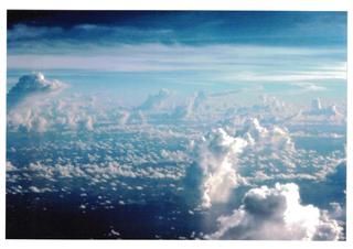
They say one picture is worth a thousand words. This is such a picture and taken over the approx track that the Lockheed was estimated to have flown over the Gilbert Islands group of atolls (now Republic of Kiribati) while trying to find Howland Island. Taken from an Air Nauru Boeing 737 circa 1979.
As mentioned before, it is all too easy to imagine how a tired crew after 18 hours of hand flying, could miss Howland Island (only 1.5 miles long) among the plethora of low altitude Cu clouds that are a characteristic of that part of the Pacific after sunrise. Each cloud casts a sun shadow on the surface of the sea that can easily be mistaken for an atoll. There are thousands of these clouds. Take your pick which could be an atoll or an illusion.
