Unfortunately I deleted it by mistake so I will rewrite it:
I put myself (and my pax) in a similar situation flying from Mt. Isa to Cairns for a Dire Straits concert. We just managed to squeeze under the overcast and above the ridges north of Cairns. It was typical S.E. stream weather and not unlike weather near the Sunshine Coast earlier this week. We were in heavy rain and I will say no more than 500" above the ridge. I was fortunate in that I new exactly where I was and I was hearing VFR arrivals into Cairns from the north. I gave myself the proverbial kick in @rse when we landed.
My previous brush with that sort of Wx was south of Cairns on my first solo nav. The plan was a departure to the north then via Biboohra to Mt. Garnet then Innisfail coastal back to Cairns. Turning east after Mt. Garnet I was faced with a wall of grey with fractocumulus and heavy showers. I turned back and landed at Mt.Garnet and re-planned on the reciprocal flight plan.
It is very easy to put yourself in that sort of situation, very important to have an exit strategy but that should never include going into IMC especially in a day VFR aircraft.
In an effort to check my spelling I came across this. Revisiting this may help others understand what they are approaching and why they should avoid it.
Forms
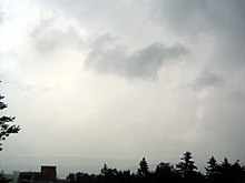

A
nimbostratus cloud in the background with a stratus fractus in the middle of the upper half of the image.
Fractus are
accessory clouds, named for the type of cloud from which they were sheared. The two principal forms are
cumulus fractus (formerly, fractocumulus) and
stratus fractus (formerly, fractostratus). Fractus clouds may develop into
cumulus if the ground heats enough to start
convection. Stratus fractus is distinguishable from cumulus fractus by its smaller vertical extent, darker color, and by the greater dispersion of its particles.
Cumulus fractus clouds actually look like ragged cumulus clouds.
[1] They may originate from dissipated cumulus clouds, appearing in this case as white ragged clouds located at significant distances from each other. Cumulus fractus in particular form on the leading and trailing edges of summer storms in warm and humid conditions.
[2] Observing fractus gives an indication of wind movements under the parent cloud.
Masses of multiple fractus clouds, located under a main cloud, are called
pannus.
Fractonimbus are a form of stratus fractus, developing under precipitation clouds due to turbulent air movement. They are dark-gray and ragged in appearance. Fractonimbus exist only under precipitation clouds (such as
nimbostratus,
altostratus or
cumulonimbus), and don't produce precipitation themselves. Fractonimbus may eventually merge completely with overlying
nimbostratus clouds.
Significance in thunderstorms
In rainstorms, scud often form in the
updraft area where the air has been cooled by precipitation from the
downdraft, thus condensation occurs below the ambient cloud deck. If scud are rising and moving towards the main updraft, sometimes marked by a rain-free base (RFB) or
wall cloud, then the thunderstorm is still developing. Scud are common and are usually insignificant. However, scud precede wall clouds, which often form from rising scud.
In addition to forming in
inflow, fractus also form in
outflow. Scud are very common on the leading edge of a thunderstorm where warm, moist air is lifted by the
gust front. Scud are usually found under
shelf clouds.
[3]