mm43;
Thank you for providing Tim's profile-view - I had seen it at some point but had lost track of it.
This will be repetitive as others who fly will have made similar observations, but...I am trying hard to come to terms with the flight path shown in Tim's schematic, and the two TCu's through which this path goes.
Even as this schematic cannot provide information on lateral deviation, I find it very difficult to accept that any crew would take such a path if not clear, even by accident, so good is this aircraft's radar. Further, I've done this many times over many decades, and so it is difficult to accept having no options but to fly into a canyon of TCu's, around which there was
no safe options for passage. This of course means nothing except that it is difficult to accept, but possible, but then that possibility begs further, more interesting questions.
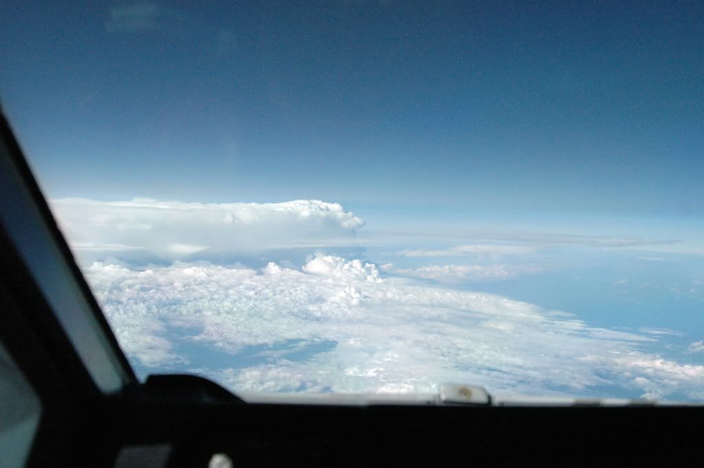
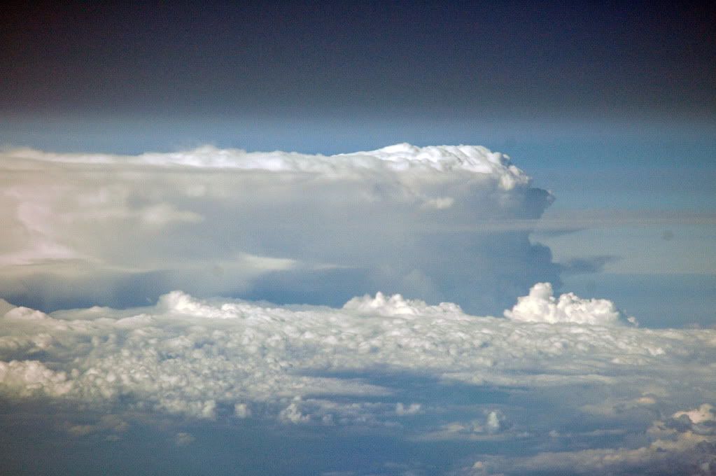
Perhaps it may help to view the following series of images which I photographed, abeam Brisbane, on a trip from HNL to SYD in December, 2006. This is in an A340. As per Tim's work, we know that the following example is not as complicated as the system AF447 faced, but using radar, paths can be found and we know this from having the luxury of examining the satellite photographs.
The potential for violent weather along the aircraft's path, as drawn, especially in the last two darker-gray areas of the last TCu could create extremely demanding circumstances for crew and aircraft alike, even without an unreliable airspeed abnormality.
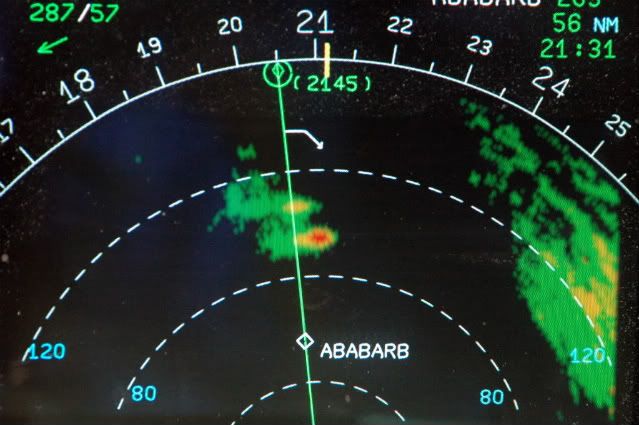
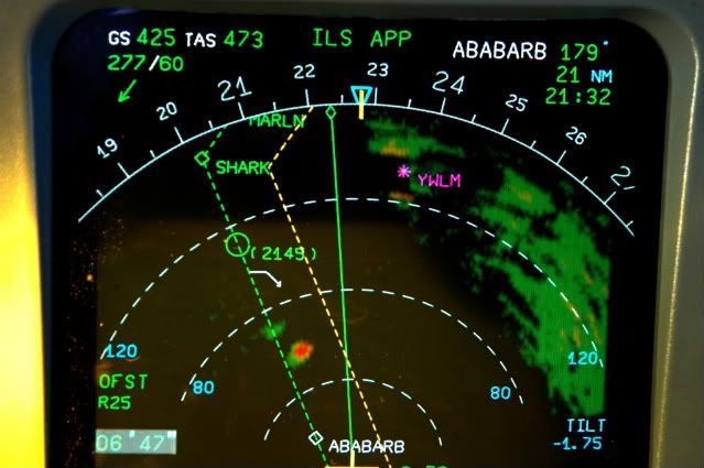
1. The first image shows the radar returns on the ND 160nm scale. The "ABABARB" is an abeam-waypoint which the FMGEC had inserted earlier when we were cleared direct to a down-route wpt. The top-right-hand display indicates an ETA for ABABARB of 21:31Z and a distance-to-go of 56nm. The white arrow pointing down just before the diamond symbol (2145) is the FMGEC-calculated start-of-descent point. The return to the far right is the Brisbane/Queensland coastal region of Australia.
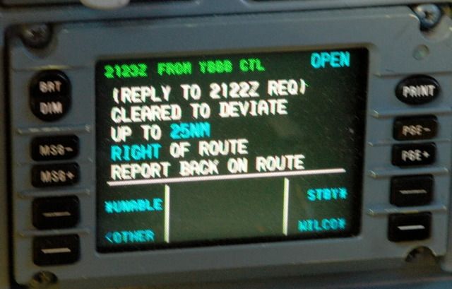
2. CPDLC displayed message from Brisbane, in response to the request to deviate to the right of course. The clearance was requested at 2122Z (in the white font) and the return message from ATC was delivered/received at 2123Z (top left corner)
3. This is what a course deviation looks like done on the autopilot using the FMGEC "Offset" capability. The green line is the flight plan route. The amber line is the FMGEC inserted offset to the right. Turning right to intercept the offset can be done using Heading mode, or it can be done on the autopilot while in the normal LNAV mode. Note the distance travelled since the first photograph was taken...about 35nm. The distance travelled towards something to be avoided is a function of communications capability. Sometimes during poor HF conditions, especially on the North Atlantic, no request, or no response/clearance might occur and one may have to request that another aircraft relay the communications. Deviating without a clearance is rare, but under the captain's authority s/he can take whatever measures are necessary for safe flight. CPDLC is essentially a "Squawk Ident" while in mid-Atlantic or mid-Pacific and so is a huge advancement in safety. The radar antenna tilt is Down 1.75deg. The beam width of the A340/A330's antenna is 2.84deg so using the 1:60 rule, one can calculate heights above and below the returns. On the lower left of the ND, is "OFST R25" for the programmed offset of 25nm. To time the deviation, the chronometer has been started, also on the lower left, and reads 6' 47".
The blue triangle at the top is the heading selection. Blue indicates that the HDG mode and not the LNAV mode is engaged, (the triangle would be magenta for LNAV).
The wind is 277T/60kts, and one can see both from the radar image and the actual photographs, that the anvil is moving to the left.
Photographs 4 & 5 are of the actual thunderstorm being painted on the radar. The tops are well above our altitude, (which was probably FL390). From the radar picture just above, it doesn't appear threatening but the photographs show otherwise.