flipster
<<No-one is afraid of talking about it - just put 'PRC112' or 'ARS6' into Google and see how much is open-source. >>
Now that's just plain disingenuous � its practical use by the RAF is a taboo subject, so far at least � your own discrediting of its usefulness is contrary to what even the manufacturers' limited blurbs claim.
<<The RDU is a very basic display that gives very raw left or right of nose indications and appox DME. >>
The left/right resolution is +/- 4 degrees which, as the range shortens, is well accurate enough to close to a fixed point where the hand set (PRC112) is located on the ground. The distance is
very accurate, just remember that it is slant range when you get close but that doesn't matter if you are going right there knowing its elevation.
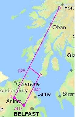
One of its stated uses is all-weather approaches to drop zones/LZs/extraction points etc. There would have been nothing wrong with approaching the LZ at way point A (the �green triangle� as locals who have seen helos land there refer to it) referring to a PRC112 that was actually on that LZ � there was a safe wave-off swinging around the back of the light house and back out to sea (plenty of room at even their highest speed) � but if they had been using it, remembering that they had already dumped their STANS local reference point (A), they would only have had their visual judgement to warn them if the set on the ground was out of position � and this is where the weather affected them:
the weather of interest was generated by the landmass and was fixed on the landmass;
the higher topographic features were shrouded in the orographic cloud and the slopes had that intermittent veil of mist running up them (strong wind causing �speed-up� effect as I have described previously) blurring ground detail making visual judgement of range impossible � it was not that they were in IMC (during the critical phase of their approach) but that the landmass that they could see (for a considerable distance) was almost as difficult to judge for distance off as would be a cloud.
Had the equipment been on the LZ at way point A, the loadmaster could have been ready to eyeball the moment that they crossed the shoreline by looking out of the side window (his usual position during any approach to, say, an LZ) � had it been further up the slope, it could have caught them out, their oblique approach taking them on a path to higher ground with no wave-off and no doubt confusing them, the loadmaster not even in his position from where they are renowned for �sideways� navigation and from where he would have been best placed to call the moment that they had crossed the shoreline � a delay of just a few seconds would have been enough to have caused this crash.
Remember also that the a/c had started to slow down (in terms of TAS) as was consistent with the matched power levels found such that they were probably �coasting in� (for a close pass of the LZ and the following swing around the back of the light house) and so they were in a worst case scenario for demanding a sudden increase in power � one of the options they would have had was a sideways slew (as I have explained previously) that causes rapid slowing and immediate increased lift which it would appear that the HP had initiated in the last seconds.
In short, the most obvious scenario is that they were to swing around the light house using a PRC112 as a reference on a known LZ (way point A) but that reference was out of position.
An exercise like this would not have affected their schedule at all as, if you recall the schematic of their planned routes that I posted some time ago:
had the weather precluded crossing the Antrim hills or approaching the MULL under VFR at all, there was a safe route already planned by Lt K (RN) which was Aldergrove to Curran (wpt H) across the top of Lough Neagh, thence to Corran (wpt B) � clear level low ground all the way;
this path was exactly the same (in terms of distance and timing) as Aldergrove to Mull (wpt A) thence NW to pick up the H-B track so all schedule and fuel calculations were the same � one of the pilots had 028 (the mag bearing from H to B) set on his HoSI course selector ready, it seems, to head for that track after their business at the Mull.
So any such training exercise would not have had any detrimental affect on the �ferry� flight had it not gone wrong � and this is in line with the RAF's stated policy of fitting in training on just about any flight where possible for obvious reasons of economy.