mm43
I reviewed the Brazilian Air Force's
notes on their aerial search for AF447. It seems that in
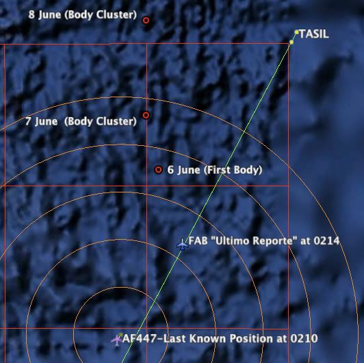
Note 3 on 1 June, 2009 the FAB estimated a last position based on time of receipt of the final ACARS message at 0214:
No padr�o de busca utilizado, as aeronaves da FAB percorrem a rota do voo AFR 447, a partir da posi��o de reporte da falha t�cnica (03� 16`28� N/ 030� 22`28� W).
That estimation put the FAB's Ultimo Reporte coordinates more than 20nm NE of the 0210 ACARS position report (Last Known Position or LKP) where/when the sudden cascade of 0210 ACARS WRN and FLT messages began.
From that point, as described later in the FAB's
Note 16 on 6 June, they organized the aerial searches northeastward:
05h00-06h30 - A aeronave sobrevoa a �rea de busca e identifica uma s�rie de pontos numa regi�o a 69,5 quil�metros a noroeste do local onde o voo AF 447 fez, �s 23h14 de 31 de maio, o �ltimo o reporte relatando uma pane el�trica no AIR BUS A- 330.
In your recent chart (Post #1670), the area labeled "Initial aerial grid search 01 June 2009" begins at the LKP, not at the Ultimo Reporte location used by the FAB and referenced in their Note 16. Their search seems to have proceeded "noroeste" from the Ultimo Reporte location, not from the LKP.
I've been unable to track down precise lat/long info for the Brazilian search grids. Perhaps you have acquired that information since your
June 6 post last year and have correctly located the "Initial aerial grid search 01 June 2009" area on your chart.
But if not, it seems the search area shown should be moved to the northeast some 20+nm along the track and maybe an uncertainty notation added to avoid confusion... If not, the "donut hole" in the FAB and BEA search patterns becomes larger.
GB