Note that is not known definitely what altitude AF447 was at. The flight plan was to be at FL370, from
Air France 447 - AFR447 - A detailed meteorological analysis - Satellite and weather data
but it has been asserted before that they would not have followed the plan and climbed from FL350 without ATC approval.
If you look at the 10min ACARS positions graphically plotted here
Flight Paths of Flight AF 447 and of the flights that crossed the zone around the same time
and in detail for AF447
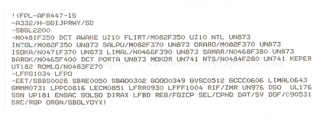
http://www.bea.aero/fr/enquetes/vol....data/AF447.txt
and assume exact times there is a slightly shorter sector between 01:50 and 02:00 which could indicate a change? Could also be due to a 15 second shorter time interval/ change in head winds etc. While FL370 may have been helpful to avoid the "SALPO storm" it would not be much use for the "Main MCS cluster"
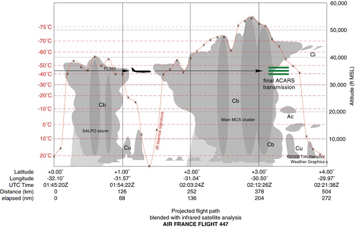
from the very early analysis by Tim Vasquez
Air France 447 - AFR447 - A detailed meteorological analysis - Satellite and weather data
Later 'official' versions available are by BEA/ France Meteo
The locked rudder limit is stated by BEA to be M0.80, but you have to guess temperature profile inside the CB to get altitude estimate at approx -40 degrees - it seems to have been very hot over the equator.