I have already made the case that the weather was misrepresented at all the inquiries such as to support the idea that they were disoriented in IMC whereas I suggest that the actual conditions had them in the clear up until the last moments but with the slopes ahead covered in ground hugging mist that made visual judgment of range to go very unreliable.
Next I would like to make the case that the a/c track was misrepresented such as to support them going straight in.
As you seem reluctant to do the chart work yourselves, I feel obliged to present it.
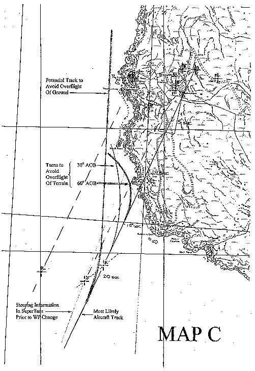
Below is the 1:10,000 map presented to the Select Committee � it�s not very clear so I have had to add bold red letters to the key points in an immediately following copy:
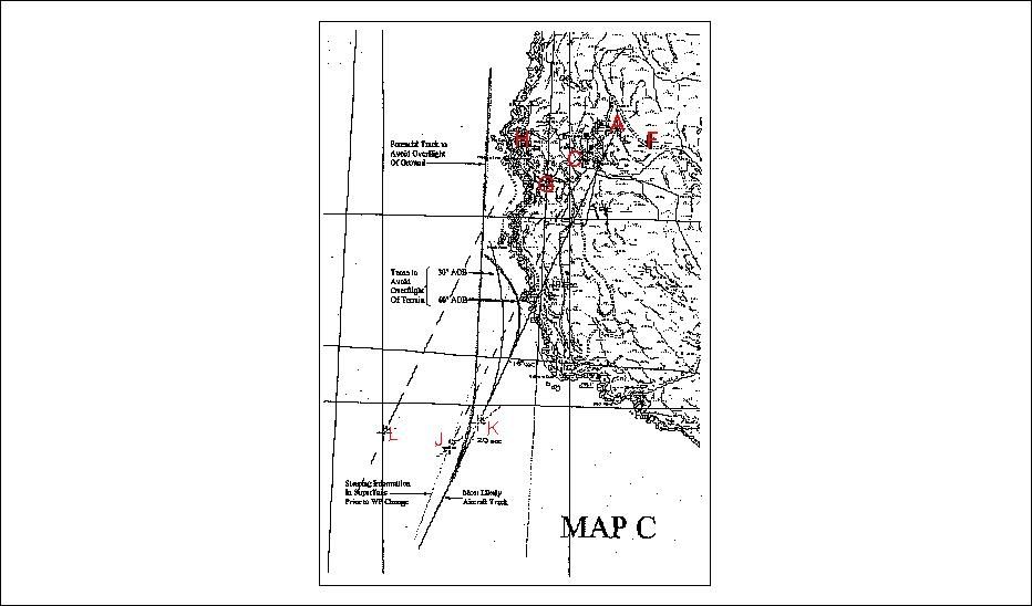 I reproduce here their key:
POSITION INFORMATION RECOVERED FROM RNS 252 SUPERTANS AND GPS
I reproduce here their key:
POSITION INFORMATION RECOVERED FROM RNS 252 SUPERTANS AND GPS
Point
Indication
A
Aircraft initial impact on Cliff A
B
RNS 252 SuperTANS calculated position at powerdown using Trimble 8000 GPS information
C
Last RNS 252 SuperTANS calculated position used for steering information displayed to pilots
D
Trimble 8000 position at powerdown in GPS processor
E
Trimble 8000 position at powerdown in output buffer of Host processor
F
RNS 252 SuperTANS calculated position at powerdown from Doppler information
G
WP A Lat/Long programmed into RNS 252 SuperTANS
H
Mull of Kintyre Lighthouse true position
J
RNS 252 SuperTANS recorded position of leg transfer to WP B
K
Most likely position of aircraft at leg transfer
L
Most likely position crew believed themselves to be at leg transfer
ANALYSIS
1.
Vector BA is error in RNS 252 SuperTANS position at powerdown.
2.
Vector JK is most likely error in RNS 252 SuperTANS position at point of leg transfer to WP B.
3.
Track KA is most likely aircraft track to impact.
4.
Track LH is possible closing track to WP A assumed by the crew.
It does not emphasise that the SuperTANS (which was found to have been reasonably accurate in the latter stages of the flight) position for waypoint A was probably the best to base analysis on;
It does not show the track from Aldergrove to waypoint change as 027m despite analysis by Boeing (Mitchel � not the simulation) that the a/c had very much held that course for the whole flight until that point, nor that extended this track goes directly to waypoint A;
It does not reflect the known turn to the right that occurred at waypoint change;
It does not represent the course as found on the handling pilot�s HSI;
It does not locate the (locally known) landing area.
So here is my version of that map with what I believe to be relevant emphasised:
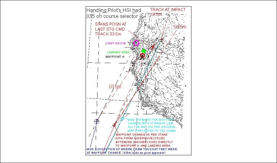 It hardly needs saying that it presents a different picture of events � the relevance of the handling pilot�s HSI course selector being on 035 (mag) is self evident.
It is intriguing how they got their position for where the pilots thought they were at waypoint change (blue circle) because if you had planned a flight to run up a distance off, but parallel to, the shoreline until you got 035m to waypoint A then you would have planned an ideal approach to that landing area � perhaps someone who had eyeballed their actual flight plan has made a Freudian slip.
One cannot help wondering that if there was supposed to be something to home on at that landing area and the handling pilot was intending to approach at 035m but in the event the �beacon� (or whatever equipment/procedure) was half a mile or so up the hill then the a/c track makes sense.
That waypoint A was more likely an inner marker for that landing area than a sloppy input for the light house is intuitively obvious.
When one considers that the handling pilot�s baro alt was set for QFI for the height of the ground at the threshold to that landing area and that one of the RADALT warnings was set at minimum (consistent with an imminent landing) it would be reasonable to assume that they were intending landing or passing closely to that landing area.
According to Boeing�s analysis (again, Mitchel � not the simulation), they had already slowed down in TAS terms by 20 kts in that final leg � something that, when at high speed in clean air, would have required a considerably lowered power which would have severely limited their options for an emergency manouevre at short notice � they had flown into a vertical corner.
It hardly needs saying that it presents a different picture of events � the relevance of the handling pilot�s HSI course selector being on 035 (mag) is self evident.
It is intriguing how they got their position for where the pilots thought they were at waypoint change (blue circle) because if you had planned a flight to run up a distance off, but parallel to, the shoreline until you got 035m to waypoint A then you would have planned an ideal approach to that landing area � perhaps someone who had eyeballed their actual flight plan has made a Freudian slip.
One cannot help wondering that if there was supposed to be something to home on at that landing area and the handling pilot was intending to approach at 035m but in the event the �beacon� (or whatever equipment/procedure) was half a mile or so up the hill then the a/c track makes sense.
That waypoint A was more likely an inner marker for that landing area than a sloppy input for the light house is intuitively obvious.
When one considers that the handling pilot�s baro alt was set for QFI for the height of the ground at the threshold to that landing area and that one of the RADALT warnings was set at minimum (consistent with an imminent landing) it would be reasonable to assume that they were intending landing or passing closely to that landing area.
According to Boeing�s analysis (again, Mitchel � not the simulation), they had already slowed down in TAS terms by 20 kts in that final leg � something that, when at high speed in clean air, would have required a considerably lowered power which would have severely limited their options for an emergency manouevre at short notice � they had flown into a vertical corner.
Last edited by walter kennedy; 10th Jan 2008 at 18:21.
Reason: correction to text