Originally Posted by
JamesT73J
From 0:50 into his video, Juan remarks that some people have given him feedback on a difference in altitude of the helicopter from before to after it is obscured by the building (being the Ellipse at Newport). There is a version of the video showing the (full) wide angle view without panning or zooming into the helicopter. So the helicopter trajectory is seen consistently, even if through a 'fish-eye' lens:
From that video, I have merged multiple screen shots. While the footage in the clip starts soon before the helicopter moves behind the building, it isn't clear to me there is any significant altitude change. So what have those people observed?

The preliminary NTSB report indicates altitude data changing from 625' to 675' msl soon before the break-up but the altitude data from ADS-B is possibly only given to a 25' resolution to start with:
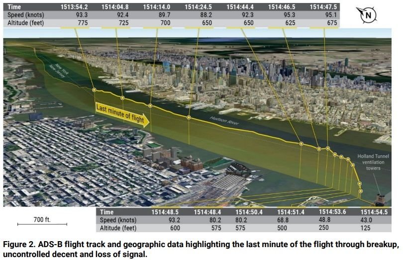
Based on projecting from ground features, the 675' data point in the report would roughly align with the helicopter emerging from behind the building in the video.
There is another point in the NTSB preliminary report that still mystifies me: It says: "...Debris was also recovered... from a rooftop near the Hoboken, New Jersey, transit building". They don't indicate what debris that was though that would have been known. Was this debris significant? Based on the description, that location is around 500m from where the helicopter experienced its sudden yaw and subsequent breakup (location is obscured behind building at lower left in video screen shot above, see my red arrow). So either (1) it already parted the helicopter earlier in its flight, (2) it was thrown back through its initial momentum or (3) it was very light and drifted with the wind to that rooftop location, which is quite separate from where the major debris items landed in the river as seen below (the video camera position is approximately at location "C" with the Ellipse building circled in yellow):
