Further to the question I asked in post #238, the Cambridge Aerospace Dictionary defines "Radio Height" as "Height above ground measured by radio altimeter". So it occurred to me that given ATSB presented synchronised plots of Corrected Altitude and Radio Height in Figure 8 & 9, then it is possible to work back and also estimate the terrain altitude as derived from the flight instruments. Furthermore, since the ground speed is also plotted in Figure 9, it is also possible to convert from a time series x axis in Figure 9 to a distance over ground.
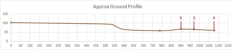
Also, Figure 6 in the report, showing the terrain profile in the area of the impact is not to scale but it does provide five key track and corresponding ground elevation points. So if we (boldly) assume the point at which the Radio Height has dropped to zero equates to the initial impact point with the ridgeline, we can overlay a semi-scaled version of Figure 6 over the converted flight path and terrain elevation derived from Figure 9.
Starting with the semi-scaled version of Figure 6 (x and y both in metres), it might look something like the following plot, with (1) being ridgeline impact, (2) being second impact and (3) being main wreckage locations:
Then merging this with the derived flightpath and terrain (again both x and y in metres) from Figure 9 as outlined above:
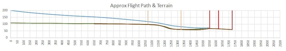
The pink lines represent the estimated start and end of the second retardant drop shown in Figure 9 of ATSB's report. Red lines are again as indicated above. The terrain as shown in the brown line has been 'massaged' to reasonably align with that derived from flight instruments (green line), but is still consistent with the information provided in Figure 6. The radio altimeter would in part be measuring the height to the top of the scrub whereas Figure 6 elevations appear to be measured at ground level.