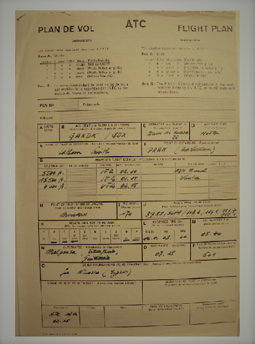
Worldair Carriers Ltd, Bovingdon. Cargo Flight - Sector Amsterdam-Brindisi. Destination Tehran.
I think this was salvaged from the wreckage.
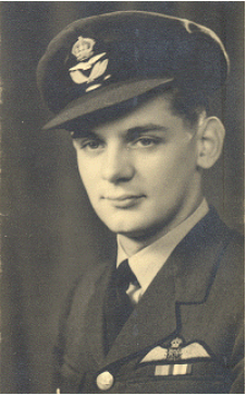
Captain Bryan Lathom-Smith 1924-1950.
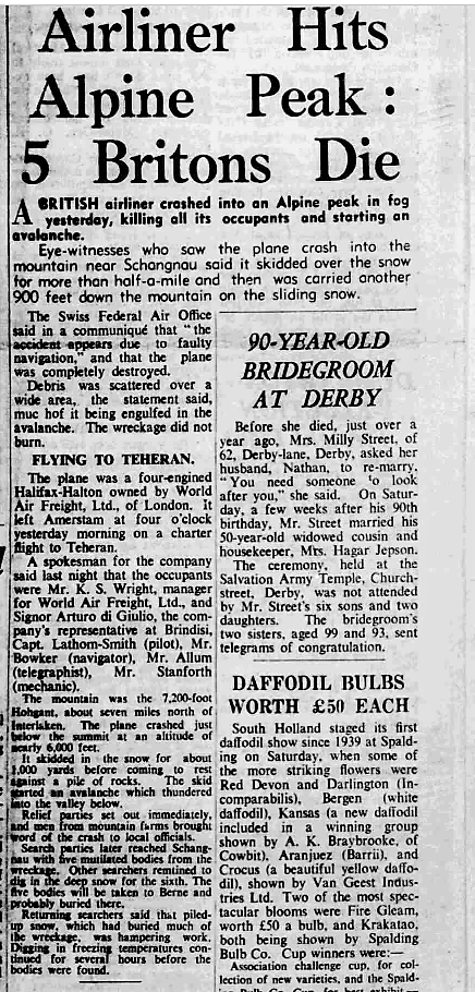
Nottinghamshire Guardian 17 April 1950 (BNA)
An uncompromising, concise bit of nineteen-fifties reporting. Presenting a questionable eye-witness account together with, I think, a premature statement by the Swiss Authorities. Very distressing to read for those so recently bereaved.
THE FLIGHT
The aircraft was at Schiphol on 14 April 1950. It was loaded on 15 April with a cargo of approx 3900 kg of Philips Domestic Radios (Model BX485AV) the sort of thing you listened to 'Mrs Dale's Diary' on - or perhaps not ? The cargo 'Volumed Out' leaving 59 sets behind and the Halton comfortably below its MTOW.
16 April - 0210z Met Briefing. Poor weather forecast en-route to overhead Venice. Cloud base on the northern side of The Alps predicted at 600-1200 metres amsl. It seems the flight had already delayed for weather and I've read somewhere that the Met Officer suggested a further delay of a couple of hours but I'm not sure. He did recommend to the crew that they should operate the sector at an altitude of 5000 metres until approaching Venice.
0245z ATC Flight Plan Filed - received at among other stations Munich-Geneva and Zurich.
5,500ft IFR 2.10hr Amsterdam - Abeam Munich
15,500ft IFR 1.15hr Abeam Munich - Venice
7,500ft VFR 2.15hr Venice- Brindisi
Fuel Endurance 7hrs.15min.
0300z Start Up. 0315z Airborne.
0422z Q coded transmission from G-AHDX to Amsterdam giving "Position at 0415z 75km west of Wiesbaden"
0449z Q coded transmission from G-AHDX to Orly "En-route to Brindisi ETA 0855 At 0415z we were approx 100km west of Wiesbaden. Our altitude 1650m amsl"
This also noted by Auxerre, Strasbourg and Nancy Radio stations.
These are thought to be the only Radio transmissions made during the flight. At 0528z the Halton, possibly climbing slightly, flew into the Yurtenfluh on the north face of Mt Hohgant, south-east of Bern and disintegrated. Impact was at approx 1700 m (5,577ft). The weather was foggy, a cloudbase of 1000m amsl in rain and wet snow. The impact triggered an avalanche carrying wreckage 500 metres down to Alp Yurtentiepe where it lay covered in snow in a strip 1.2km x 200m. The bodies of 4 crew members and the Company's Brindisi Manager were efficiently recovered and taken to Bern. Investigators from the Swiss Federal Aviation Office were quickly on the scene and I think on that same day they recovered a damaged Navigation Chart which indicated that the Halton was approx 250km west of its flight planned route.

Point of impact. The Avalanche travelled down the adjacent slope to the left.
A Police appeal for witnesses resulted in reports from as far away as 60km to the north establishing the direction of flight south-wards towards Mt Hohgant. Rarely glimpsed through low cloud the aircraft was heard cruising steadily low. Because of Fog the crash was said not to have been seen but that the impact was widely heard as was the resultant avalanche. A witness mentioned hearing the engines being 'Throttled' just before impact.
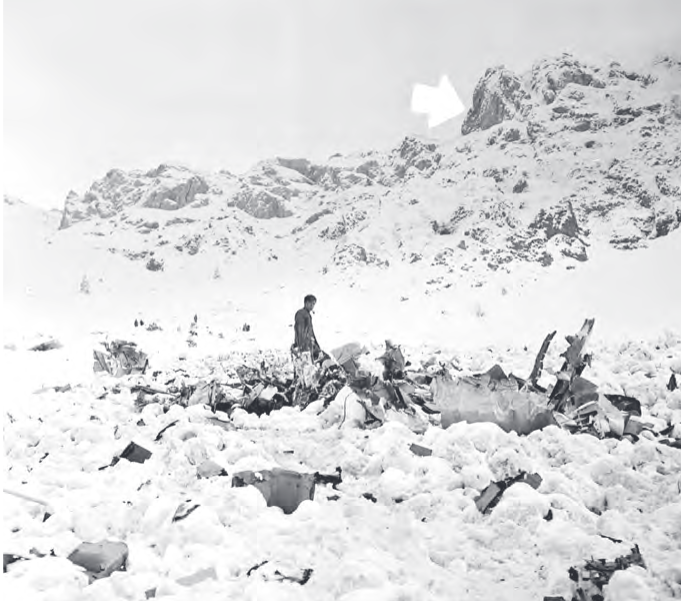 Photo: Walter Nydegger/Roger Cornioley.
https://www.britishpathe.com/asset/70429/
Photo: Walter Nydegger/Roger Cornioley.
https://www.britishpathe.com/asset/70429/
Although it was a three hour climb to the crash site sightseers and souvenir hunters turned up. Despite a Cordon being in place and with only limited policing being available (initially the Village Bobby from Schangnau) pilfering of wreckage, documents and radio parts occurred, the latter being very popular. Several prosecutions resulted.
Further recovery operations were not possible until the snows melted. One crew member was still missing.
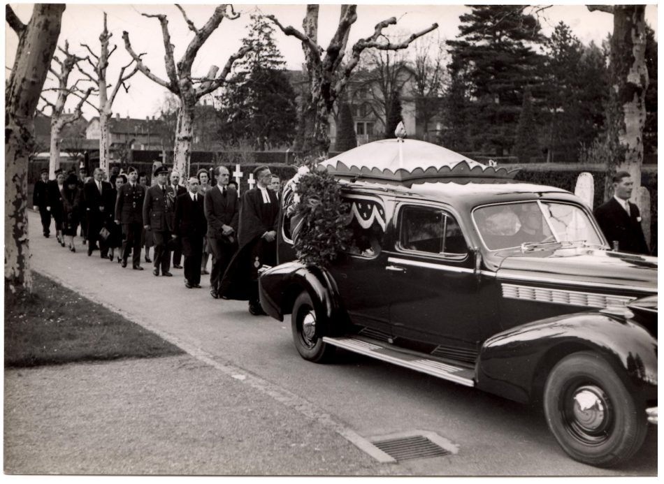
Photo Chris Latham-Smith with thanks.
The Crew's Funeral at the Bremgarten Cemetery Bern on 19 April 1950.
On the 13 May 1950 the body of the Radio Operator Keith Allum was recovered and subsequently buried in the Churchyard at Schangnau.
25 May - Aerial Survey of site. 30th May - Scene inspected, documents recovered which proved valuable to investigators. Human remains buried on the spot.
3 -4 June Thorough search conducted with supervised team of 16 Scout Rovers looking for Ship's Papers and sorting wreckage. Debris in a niche in the rock 50 metres above impact point included parts of Philips radios , a rudder bar and a trim wheel. Debris at the foot of the cliff face and just below included the remains of a magnetic compass and a damaged aircraft radio. There had been a small engine fire on impact. No indications were found that the aircraft or its engines were defective at the time of the accident.
 WEATHER
The Met Folder was salvaged but was very badly damaged. The data I've reproduced here was produced by The Swiss Aviation Weather Service mainly after the accident and I acknowledge the use of their images and data.
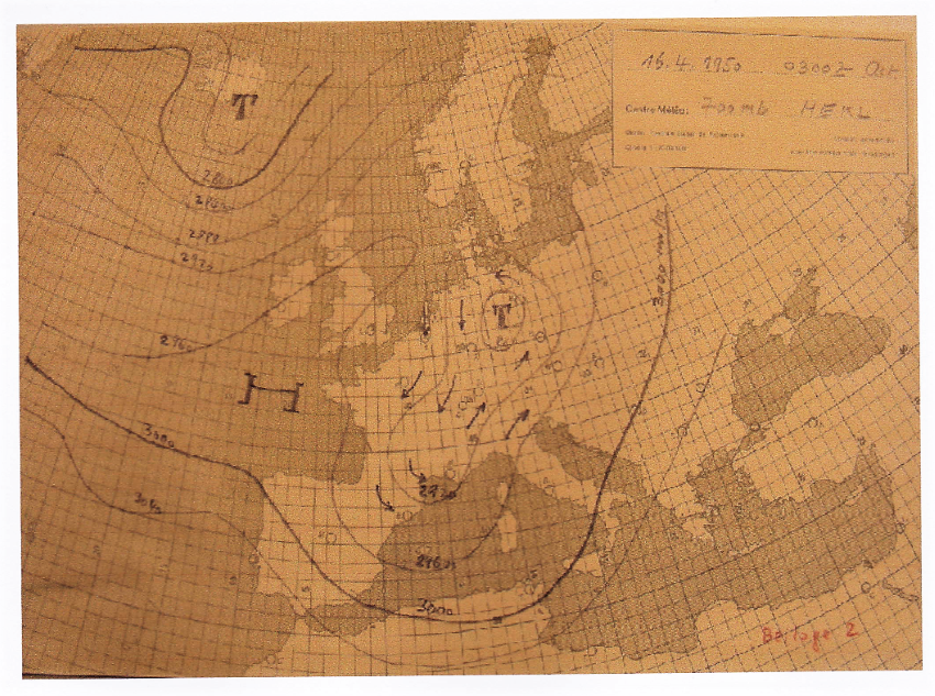
The flight had operated from Schiphol almost entirely in heavy layered cloud. The Swiss Aviation Weather Office calculated that isolated cloud breaks might have allowed ground visibility for about 10% of the route. Very much the whole of the Swiss Alps were covered with layered cloud and emerging Cumulus. A KLM Constellation (PH-TDC) northbound over the alps near Lucerne at 0700z that morning reported a solid ceiling of cloud with a strong swelling surface and tops at about 3000m amsl.
Forecast Winds 0300z-0600z 16 April 1950.
HOLLAND --SAAR- --MITTLELLAND--SALZBURG
1000m N10--NNE5----- NNW15----------- SW5
2000m N10--N20 -------W10---------------WSW5
3000m N20--N25------- NW5--------------SW10
4000m NE40-NNE45-- SW47----------- SW50
ICING
As a rank amateur I think that the Captain's decision to fly from Schiphol to Abeam Munich at 5,500ft rather than at 5000m as suggested by the Met Officer was quite understandable. By flying at 5,500ft he would hope to minimise icing, conserve oxygen and mitigate the effects of the cold. These factors were acknowledged by the investigators. The Captain was an experienced Halifax pilot who had flown in The Berlin Airlift. During the Airlift the Halifax, having no wing deicers had often encountered problems, particularly at night and in winter when attempting to operate at the stipulated altitude of 6000ft. This resulted in delayed or aborted missions. When BOAC initially took delivery of their Haltons in 1946 the fleet had to be grounded after a short time in service and returned to the manufacturer for modification due to inadequate wing deicing. G-AHDX would have been modified accordingly.
Forecast Icing Index 16 April 1950
Holland 0c 1200m
Switzerland 0c 1000m
-10c 2600m
-20c 6000m
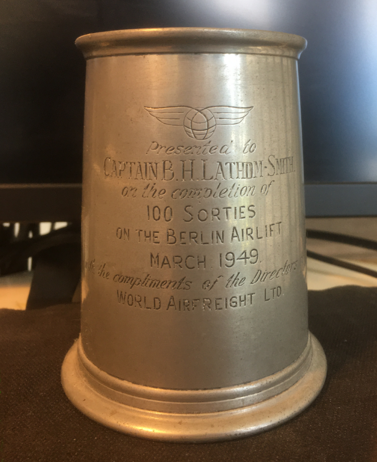
Photo:Chris Latham-Smith.
ATC postwar Western Germany and Radio Silence.
British Sector: RAF Bad-Eilsen: FIR with ATCC providing FIS only.
French Sector: Eastern FIR controlled by FIC Strasbourg.
American Sector. USAF Frankfurt and Munich Area Control Centres and FIRS.
Civil Flights within Germany were only conducted by aircraft of the Occupying Powers. Routes to and through Germany were very few. Cornioley (2012) mentions that the Captain had forgotten to obtain German overflight permission. He doesn't enlarge on the matter. The relevant authorities would have been aware however when the ATC Flight Plan was filed.
The investigators noted that the last transmission heard from the aircraft was at 0449z. Here I quote roughly from an official document: (I am by this time, lost in translation). 'The aircraft did not work with the Swiss radio surveillance authorities nor was anything heard from it. The assumption is that after the 0449z report there was no radio communication with ATC since the aircraft assumed it was in the French occupied zone of Germany where there is an ATC no-man's-land in which no ATC checks are carried out. Whether the aircraft was receiving with its radios without transmitting could not be determined from The Radio Officer's scanty notes recovered from the wreckage. There is a presumption that a few minutes before the accident a bearing was taken on the
'UE' radio beacon near Bern. Since no radio traffic was observed during the second half of the flight it can be assumed that perhaps the radio system was unusable; then the onward flight would definitely have to have taken place at a higher altitude
or it can be assumed that everything on board is in order and therefore no reports were given.'
The tuning box of an aircraft radio was recovered. The setting scales were still recognizable. This damaged component could not be fully identified. Photographs and sketches were sent to England for further analysis.
THE WIDER PICTURE
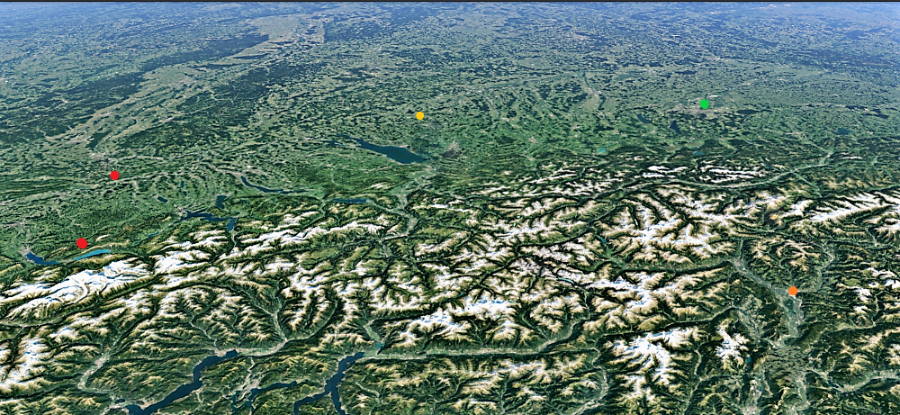
Looking NNW.
TOP RED: 0515z near Balsthal where first reports came of aircraft heard in the clouds. Approx 375 S Miles from Amsterdam.
BOTTOM RED: 0528z Impact Point.
YELLOW: Planned to be overhead at 0525z point 'Abeam Munich' 351 S Miles from Amsterdam and 33 S Miles N/W of Menningen. Navigator's chart marked 0515z at Menningen.
GREEN: Munich.
BROWN: Bolzano Italy. Waypoint crossing The Brenner Pass.
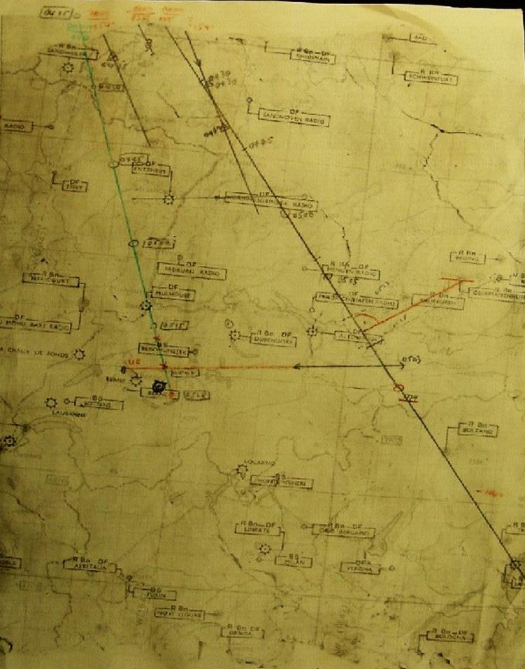
The Navigator's damaged chart salvaged from the wreckage on the day of the crash Photo: Swiss Federal Aviation Office. The coloured lines (difficult to distinguish) are those of the investigators. The Navigator's pencilled times are best seen using a magnifying glass !
CONCLUSION
I have not seen the Accident Report and have worked off Official Documents prepared in connection with the accident.
The investigators cited extremely poor weather, insufficient safety margins and poor navigational preparations as being the cause of the accident. They suspected from looking at the Navigator's salvaged chart that a bearing had been taken shortly before impact off the Uettligen Beacon near Bern at a range of 20 miles. This whilst trying to establish their position 'Abeam Munich'. The latest time written on the chart appears to be 0523z. The investigators were critical of the crew for not initiating an immediate climb to 15,500 ft when doubts about their position must have first been raised in the Navigator's mind.
To put it simply the Navigator had from the very start anticipated strong south-westerly winds instead of northerly winds on their track of 144 Degrees and maintained this assumption throughout the flight. The investigators noted that some of the cargo had been loaded in the nose compartment and possibly in the crew compartment too. The radio speakers contained a strong magnet. Tests were conducted for compass error but no firm conclusions were reached. Chris Latham-Smith added that if there had been such a problem his Father, who did everything by the book, would have noticed a compass problem on start up at Schiphol. The investigators also mentioned that 'The Twilight Effect' (Dawn) may also have caused problems while the crew were trying to establish their position.
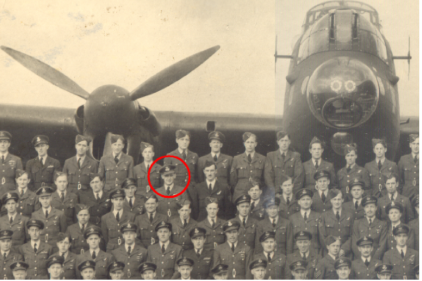
Photo: Chris Latham-Smith.
Bryan Lathom-Smith had flown many missions as a Pathfinder Pilot with 7 Squadron Royal Air Force.
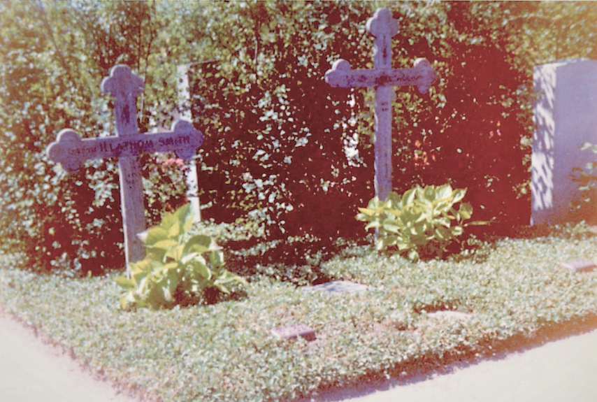
Photo: Chris Latham-Smith.
THE CREW
Captain: Bryan Lathom-Smith 26 years old.
Navigator: Charles Henry Bowker 20 years old.
Radio Operator: Keith Allum 18 years old.
Flight Engineer: David Stanforth 25 years old.
K.S. Wright: Company Manager and acting Steward.
Arturo di Giulia. Passenger - Company Manager Brindisi.

The Church at Schangnau.
I would like to thank Chris Latham-Smith for his assistance, images and enthusiasm. He lost his Dad when he was 9 months old but had a happy childhood and now aged 73 is alive and kicking, living in France. I would also like to thank Hans Peter Tschanz in Switzerland without whose generous help this would not have been written. Further Reading: 'Zerschellt im Hochgebirge' by Roger Cornioley. Bern 2012. Can be read on the Internet in German.