Sunfish - Instead of bitching here, why do you not call the AIS section at Airservices and establish the facts?
For info, WAC charts are produced by Geoscience Australia. They are now starting to digitise so we will eventually see more current information on WACs.
Australia’s Aeronautical charts go digital
Geoscience Australia is collaborating with Airservices Australia to revise their World Aeronautical Charts (WAC).
World Aeronautical Charts are 1:1 000 000 scale paper maps used by pilots for flight planning and in-flight navigation on extended cross-country flights at low to medium altitudes and medium to high airspeeds. Forty-two WAC sheets provide complete coverage of Australia.
Whereas previous WAC revisions involved traditional manual cartographic techniques on film, the new Tasmania WAC has been produced from Geoscience Australia’s fundamental topographic database, GEODATA TOPO–250K Series 2.
This new collaboration involves extracting the 1:250 000 scale topographic data from Geoscience Australia’s seamless geographic database. Using the previous edition maps as a guide, the features are then tagged for future use at 1:1,000,000 scale.
The updated aeronautical information from Airservices Australia is then incorporated into the new database. The refreshed data is then symbolised, cartographically offset and annotated to produce a WAC with the same look and feel as previous editions.
New WACs for Albany, Armidale, Cooper Creek and Perth will soon be available as part of an ongoing agreement between the agencies for the production of a national 1:1 million scale seamless database and the complete revision and production of the entire WAC series covering Australia.
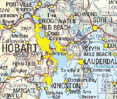
Figure 1. Extract of 1:1 million scale World Aeronautical Chart for Hobart, Tasmania
As with the production of Geoscience Australia’s 1:250 000 topographic NATMAP products, four spatial information companies are being contracted to produce the WACs.
Airservices Australia and Geoscience Australia have a long history of working together to produce various scale flight navigation charts like the WACs, 1:500 000 scale Visual Navigation Charts (VNC) and 1:250 000 scale Visual Terminal Charts (VTC).
Working together has many benefits for both agencies. Future revision of the digital data will be more efficient. The same data can be used in the production of other maps like Airservices Australia’s VNCs and Geoscience Australia’s Global Map data. Digital data could also enhance Airservices Australia’s ‘Flying Around’ (a new online delivery of VTCs), or be used in any future online or in-flight navigation.
For more information phone Phil Tickle on +61 2 6249 9353 (email
[email protected])