Originally Posted by
CurtainTwitcher
Is 2000 lbs / 900kg over RTOW on two engines going to have a dramatic impact on the climb performance to the extent it is discernible in a newspaper graphic (
Reuters link to graphics), especially given the scale? Single engine, yes, but that wasn't the scenario.
No idea how exactly Reuters created that graph, but it doesn't seem to match what happened accurately at all:
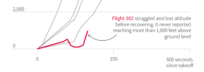
The Reuters graph is labeled "GROUND Altitude From Addis Ababa’s altitude of 7,625 feet" and they claim it's based on "altitude data from the flight, released by Flightradar24".
It seems to suggest that the aircraft reached only about 500 feet AGL before MCAS activated, and it almost touched the ground as a result. Everything I've seen so far contradicts that.
The FR24 data is the ADS-B reported pressure altitude, and needs to be corrected based on the actual pressure at the time of the flight, otherwise the graph will show the plane departed from 425 feed below ground level.
If you do that, the FR24 data looks like this, quite different from the Reuters graph:

I'm not sure if the ADS-B reported pressure is corrected based on the AOA and airspeed. If it is, then even my graph would not be accurate, showing lower altitudes, the actual altitude would be higher. On the DFDR traces from the preliminary report the computed left and right pressure altitudes diverge progressively, reaching more than 1000 feet difference as the speed increases. This could make even the altitude loss from my graph show as worse than it actually was. The aircraft could be at 1500 feet AGL, when ADS-B would show it at 500 feet AGL.
In any case, it shows that at 05:40:00Z, when MCAS first activated, the aircraft was already descending.
Finally, I scaled the altitude graph from the preliminary report, compressing the time axis 10 times, to get a scale factor more similar to the Reuters graph and my graph:
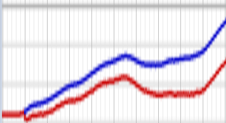
The blue trace is the corrected pressure altitude from the right side, with the functional AOA sensor, the red trace is from the left side, with the broken AOA sensor.
Each vertical division is 1000 feet. The red trace seems to match the FR24 data, so it seems the ADS-B information was incorrectly adjusted due to the broken AOA sensor. According to the trace from the right side, with the functional AOA sensor, the aircraft actually reached about 1500 feet AGL before it started descending, and only lost about 250 feet of altitude, instead of 450 feet like the FR24 data shows.