Originally Posted by
chevvron
From a discussion on another website, the airfield you have marked is the original Heathrow airfield; Faireys Great West was to the north west of this, abutting the A4 Great West Road near the 'Peggy Bedford'.
Found a better picture to resolve any remaining confusion:
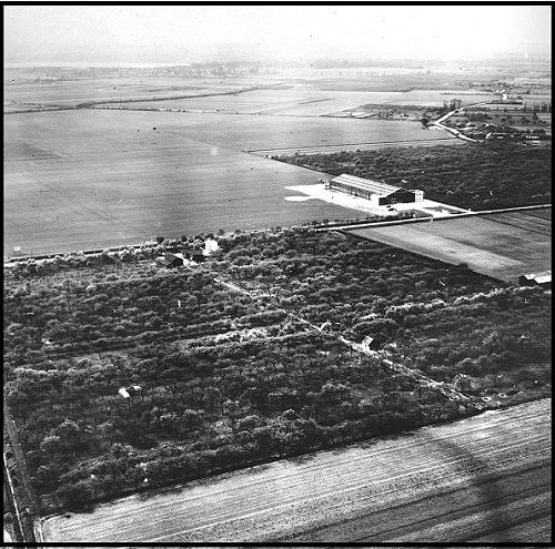
This shows Fairey's Great West Aerodrome, presumably not long after the hangar was built as none of the ancillary buildings are present. It doesn't yet have "Fairey" painted on the roof, though it does by the time the photo at the bottom of
this page was taken in 1934.
The hangar was at the northmost point of the airfield, whose boundaries can be clearly seen in conjunction with the map in my previous post: Cain's Lane in the foreground (running NW-SE), Heathrow Road in the top right (ran from the Three Magpies to Perry Oaks), High Tree Lane (to West Bedfont) running across the top of the photo and, just visible at the top left, the line of the Duke of Northumberland's River.
So no part of the airfield extended as far as the Great West Road, in fact the Fairey hangar was roughly where Terminal 2 is nowadays, as the crow flies almost exactly a mile and three-quarters distant from the Peggy Bedford (as was).
Hope that helps.
