As requested, I have done some work with Google Earth to compare the flight paths of VH-ZCR and N726CB, the latter being the King Air B200 that took off from Hayward Executive airport, California on 16/9/2009, with full nose-left rudder trim.
N726CB veered left after becoming airborne and struck the roof of a 10 metre high (estimate) building. The point of impact was 15 degrees off the runway azimuth, at a distance of 670 metres - measured from the lift-off point. I have assumed a distance of 500 metres for this takeoff roll (see attached image).
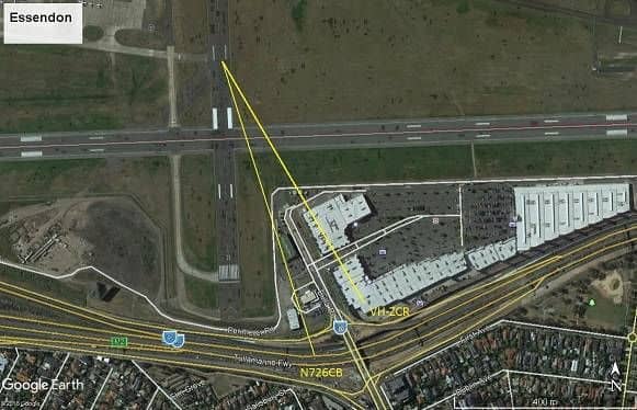
For the takeoff of VH-ZCR, I have drawn a line of the same vector onto the Essendon image, to see how close the two impact points are (see image).
The two points are about 150 metres apart. ZCR has veered more, which could be explained by its 15 knot greater airspeed at lift-off (assuming that N726CB rotated at a normal speed). The greater airspeed would give a greater initial nose-left yawing moment.
Another possible explanation: the pilot of N726CB had 37 year old knees, as compared to the 76 year old knees in ZCR.
The distance from lift-off to impact for N726CB was about 670 metres. For ZCR, this distance was about 620 metres.
The biggest unknown in this exercise has been the length of the takeoff run for N726CB. I have assumed 500 metres, but if that actual takeoff had got off to a more leisurely, rolling start, then this distance could have been closer to 600 metres, which would have put the endpoints of the two vectors within about 75 metres of each other.
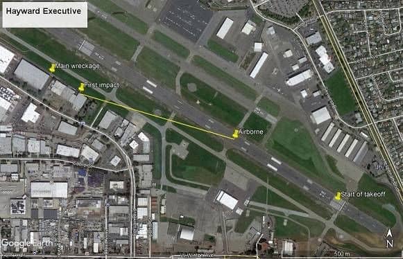
Those wishing to check my work should have a look at this image, from the NTSB:
https://aviation-safety.net/photos/displayphoto.php?id=20090916-0&vnr=1&kind=G