Do you mean like the example below?
If you do, then the VOR (or VORs in this case) are used to identify the intersections used on the approach and missed approach. As previous posters have said, any ground-based aid may be used on an approach - VOR, DME, NDB, etc.
Consider you are flying the example ILS without the help of a GPS or FMS/FMC.
The only way to identify the waypoints on the approach is to have both the ILS and the VUH VOR dialled up - likely the ILS on NAV 1 and VOR on NAV 2. If ATC asked you for a report crossing CARCO, you would make that report once you were indicating 15.7 miles to go on the ILS centreline, and passing through the 285-degree radial from the VUH VOR. Likewise, at 5.8 miles to go on the ILS centreline and crossing the 301-degree radial from VUH, you'd be overhead EISEN.
Furthermore, the missed approach procedure is based on the HUB and MHF VORs. That is, you'd fly outbound on the HUB 040 radial until crossing the MHF 308 degree radial, which is approximately 15 DME from HUB (shown by the D15.0 in the missed approach diagram). That point in space forms the RAYCI intersection, and it is here that you would fly a parallel entry to establish yourself in the published holding pattern.
If the chart maker did not include the VOR information on the chart, then you'd have to go searching on another chart for the frequencies and ident information. That increases pilot workload and decreases situational awareness. It is far better to put that all on the chart and make the pilots' life easier.
Now, all this is all made much easier again (and slightly redundant) by loading the approach from a GPS unit or FMS/FMC. These waypoints that are formed by the intersection between an ILS and VOR signal (or any other combination of ground-aid) have GPS coordinates that are loaded into the GPS/FMS/FMC approach database. The waypoint is automatically retrieved when the pilot programs the approach, so the navigation aids used to form that intersection in the first place need not be monitored (unless told to by their company or personal preferences). You'll still load up and fly the ILS, but you'd identify the waypoints from the GPS.
I hope that helps!
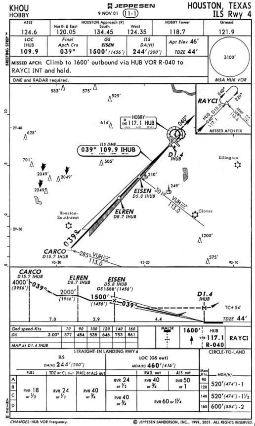 KHOU ILS Rwy 4. Source: Soonerace (https://soonerace.wordpress.com/2017...arture-charts/)