


SkyDemon vs. Foreflight

Thread Starter
SkyDemon vs. Foreflight
For about 5 years I've been running ForeFlight on a cellular iPad 128 gB for my 4 weeks or so in the USA and SkyDemon on the same device for all the rest of the time in the UK. My flying is VFR in DA-40, PA-28 and 172 in various bits of the USA and at Redhill.
ForeFlight has some useful additions like the numbers of weather charts that can be imposed and the synthetic terrain (useful in the mountains of Colorado) but the charts have not been good for UK VFR & I don't believe they do UK NOTAMS.
Now ForeFlight have started doing European charts, could I realistically go over to it full time in the UK as well ? and abandon SkyDemon
My SkyDemon has a Pooley's subscription with it, which I also find useful, what does ForeFlight have as an equivalent ?
All comments on the relative pros and cons gratefully received.

Join Date: Jan 2012
Location: Lancashire & Florida
Posts: 129
Likes: 0
Received 0 Likes
on
0 Posts
For about 5 years I've been running ForeFlight on a cellular iPad 128 gB for my 4 weeks or so in the USA and SkyDemon on the same device for all the rest of the time in the UK. My flying is VFR in DA-40, PA-28 and 172 in various bits of the USA and at Redhill.
ForeFlight has some useful additions like the numbers of weather charts that can be imposed and the synthetic terrain (useful in the mountains of Colorado) but the charts have not been good for UK VFR & I don't believe they do UK NOTAMS.
Now ForeFlight have started doing European charts, could I realistically go over to it full time in the UK as well ? and abandon SkyDemon
My SkyDemon has a Pooley's subscription with it, which I also find useful, what does ForeFlight have as an equivalent ?
All comments on the relative pros and cons gratefully received.
ForeFlight has some useful additions like the numbers of weather charts that can be imposed and the synthetic terrain (useful in the mountains of Colorado) but the charts have not been good for UK VFR & I don't believe they do UK NOTAMS.
Now ForeFlight have started doing European charts, could I realistically go over to it full time in the UK as well ? and abandon SkyDemon
My SkyDemon has a Pooley's subscription with it, which I also find useful, what does ForeFlight have as an equivalent ?
All comments on the relative pros and cons gratefully received.

Join Date: Mar 2014
Location: The World
Posts: 1,271
Likes: 0
Received 0 Likes
on
0 Posts
I abandoned Skydemon a while ago, because I don't trust Skydemon any more.
We all fly quite addicted along Magenta Lines, so charts have to be precise.
So, i.e. why are NOTAMS not shown correct in Skydemon? Example:
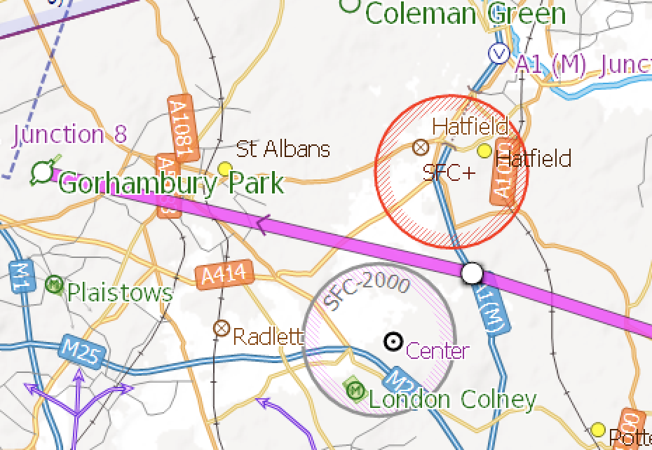
This 'Center' is not centered and maybe the planned flights corridor does not exist in reality!?
I realized the discrepancies when using a trial of ForeFlight Europe with the graphical NOTAMs update.
Taking some random NOTAM circles and inserting the center it seems Skydemon is sloppy in processing data.
Added this i.e. to the discussion on why they use rhumb lines instead of great circle and other behavior.
Decided I am out of Skydemon for now, too potentially dangerous for me flying.
I do like the charts representation clear structure, but cannot live with wrong data.
My 2 pennies.
We all fly quite addicted along Magenta Lines, so charts have to be precise.
So, i.e. why are NOTAMS not shown correct in Skydemon? Example:
This 'Center' is not centered and maybe the planned flights corridor does not exist in reality!?
I realized the discrepancies when using a trial of ForeFlight Europe with the graphical NOTAMs update.
Taking some random NOTAM circles and inserting the center it seems Skydemon is sloppy in processing data.
Added this i.e. to the discussion on why they use rhumb lines instead of great circle and other behavior.
Decided I am out of Skydemon for now, too potentially dangerous for me flying.
I do like the charts representation clear structure, but cannot live with wrong data.
My 2 pennies.
Last edited by ChickenHouse; 8th Sep 2019 at 18:14.
Join Date: Apr 2019
Location: EDSP
Posts: 334
Likes: 0
Received 0 Likes
on
0 Posts
I abandoned Skydemon a while ago, because I don't trust them any more.
We all fly quite addicted along Magenta Lines, so charts have to be precise.
So, i.e. why are NOTAMS not shown correct in Skydemon? Example:
This 'Center' is not centered and maybe the planned flights corridor does not exist in reality!?
I realized the discrepancies when using a trial of ForeFlight Europe with the graphical NOTAMs update.
Taking some random NOTAM circles and inserting the center it seems Skydemon is sloppy in processing data.
Added this i.e. to the discussion on why they use rhumb lines instead of great circle and other behavior.
Decided I am out of Skydemon for now, too potentially dangerous for me flying.
I do like the charts representation clear structure, but cannot live with wrong data.
My 2 pennies.
It seems it's not better than 0.5NM at least for this type of shape.
Definetly not good. However I would sugget to keep clear more than 1NM of places where you should not be. You wouldn't fly that course with a 1:500.000 map either.
Join Date: Mar 2014
Location: The World
Posts: 1,271
Likes: 0
Received 0 Likes
on
0 Posts
@BDAttitude: yes, all I saw was Skydemon using only the Q-line of the NOTAM, or ‚the area of interest‘ in aviation terms, and not the real coordinates of it. This is really real bad tinkering and a German friend forwarded me PN with clear evidence Skydemon states ‚pilots have to read the NOTAM anyways‘ - so they know their chart representation is definitely wrong and don‘t do about! No, we don‘t talk half a nautical, we may talk any charts points are wrong up to 1.5 nauticals in Skydemon.
Everybody may be free to take hisherit own facts out of it, I decided to take that serious for me. I switched my VFR flying, US and Europe, to ForeFlight - much better feelings, not to speak of also much better feelings of being treated as a real valued customer in support, something I did miss sometimes in Skydemon discussions.
Everybody may be free to take hisherit own facts out of it, I decided to take that serious for me. I switched my VFR flying, US and Europe, to ForeFlight - much better feelings, not to speak of also much better feelings of being treated as a real valued customer in support, something I did miss sometimes in Skydemon discussions.
Last edited by ChickenHouse; 8th Sep 2019 at 18:19.
Join Date: Apr 2019
Location: EDSP
Posts: 334
Likes: 0
Received 0 Likes
on
0 Posts
Currently the vector map of SD is so much superior that I will not change yet. However when FF gets a proper map that will change very fast and they will have to do something, also with their �choice� mehr of approach charts. I'm not sure if they will be able to counter that for a long time.
Join Date: Sep 2010
Location: Sherborne, UK
Posts: 70
Likes: 0
Received 0 Likes
on
0 Posts
One major defect with the NOTAM system is that there is no central body who makes sure that NOTAMs are formatted in a standard way. What this means is that the main text of the NOTAM is not fit for any parsing system that demands good machine readable data.
In some cases (usually where airspace is created by NOTAM) we take the extra steps to go through the NOTAM text and properly draw the true lateral limits of that created airspace. Unfortunately, this cant be a fully automatic process (yet) and so broadly we will fall back on the Q-line, since that is the one part of the NOTAM which is consistently formatted.
Obviously ChickenHouse is entitled to choose their flight planning tools based on whatever metrics they choose, but to say that we knowingly present incorrect data is false and misleading. Not only do we work very hard to present a correct picture as per the official data, but we also help AIS units to present their official data in a more streamlined way that benefits users of all products. If anyone sees anything that causes them to question our accuracy I would implore them to draw our attention to it - we may be able to immediately resolve the matter within the SkyDemon code, and if not we will address it to the relevant authorities.
Rob | SkyDemon
Thread Starter
Since my original post and 6 hours in a 172 in Colorado, I have no early intention of abandoning Foreflight in the USA, nor SkyDemon in the UK and Europe. Any GPS system needs to be used with the caveat that if you are using it for VFR don't try and go where you couldn't using a 1:500 chart.
Still open to views and comments and if Foreflight start using CAA charts, that'll open up a whole new question.
Still open to views and comments and if Foreflight start using CAA charts, that'll open up a whole new question.
Join Date: Mar 2014
Location: The World
Posts: 1,271
Likes: 0
Received 0 Likes
on
0 Posts
Others get it right, I don’t care whether manual or by more precise parsing. My philosophy is to buy precise instead of cheap, others are free to object to for their own. NOTAMs are written in almost free format, which I like and welcome, and I expect them to follow natural language, not computer speak.
Join Date: Apr 2019
Location: EDSP
Posts: 334
Likes: 0
Received 0 Likes
on
0 Posts
Since my original post and 6 hours in a 172 in Colorado, I have no early intention of abandoning Foreflight in the USA, nor SkyDemon in the UK and Europe. Any GPS system needs to be used with the caveat that if you are using it for VFR don't try and go where you couldn't using a 1:500 chart.
Still open to views and comments and if Foreflight start using CAA charts, that'll open up a whole new question.
Still open to views and comments and if Foreflight start using CAA charts, that'll open up a whole new question.
The same scenario with Rogers Data (austrian official provider) is a bit more expensive but you have one style for all european charts. I'll have to get one paper chart and try if it works good for me.
Those are no vector charts though, so it'll get coarse if you zoom in. However that might prevent you from going into the trap of overzooming we have both mentioned.
I still can't understand it that no company is able to give me me a reasonable flat rate offer for the 30 hours/year I fly with a radius of 400nm around my home base. 500€/year is not acceptable.
Edit:
I also do not understand why no one produces a proper aeronautical base maps without the airdata. Airdata can and should be added by the apps.
From certain examples (roads, city shapes) I can see that the vector base map from SD isn't excactly up to date. The shape of my home town is pre Y2K.
Last edited by BDAttitude; 10th Sep 2019 at 14:01.
