


Epsom NDB - did it move?


Thread Starter
Join Date: Mar 2021
Location: UK
Posts: 3
Likes: 0
Received 0 Likes
on
0 Posts
Epsom NDB - did it move?
I've joined this site just to ask this one question!
In about 1972 I listened to a conversation between two British radio amateurs discussing the Epsom NDB (EPM). Living in the area I already knew that EPM is actually a few miles away in Stoke D'Abernon. One of the guys was saying that the beacon had originally been in Epsom itself but had been relocated. I can't find anything on the web to support this. Can anyone confirm please and if it was relocated, when, and whereabouts in Epsom was it originally located? I have read that aircraft once circled over Epsom Downs to hold. Is this perhaps the answer?
In about 1972 I listened to a conversation between two British radio amateurs discussing the Epsom NDB (EPM). Living in the area I already knew that EPM is actually a few miles away in Stoke D'Abernon. One of the guys was saying that the beacon had originally been in Epsom itself but had been relocated. I can't find anything on the web to support this. Can anyone confirm please and if it was relocated, when, and whereabouts in Epsom was it originally located? I have read that aircraft once circled over Epsom Downs to hold. Is this perhaps the answer?

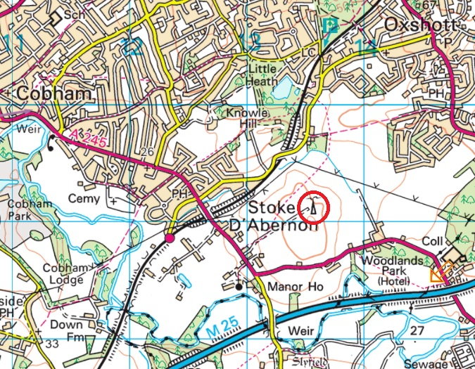
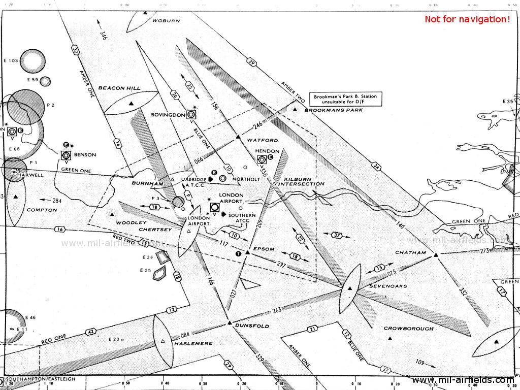
The location of the Epsom NDB 'EPM' (freq 316 kHz) is the same today as it was in 1969 (chart shown below), approx 5 statute miles WSW of the centre of Epsom town, but I don't know its history prior to that. EPM is the holding pattern for aircraft to proceed to after missed approaches from LHR runway 09R/27L.
ILS chart R27L
ILS chart R27L
Last edited by Discorde; 10th Mar 2021 at 16:49.
Avoid imitations
Join Date: Nov 2000
Location: Wandering the FIR and cyberspace often at highly unsociable times
Posts: 14,573
Received 422 Likes
on
222 Posts
I think one edition of the CAA charts might have "moved" it by mistake, along with the Princes Risborough mast, which suddenly appeared near Banstead!
The location of the Epsom NDB 'EPM' (freq 316 kHz) is the same today as it was in 1969 (chart shown below), approx 5 statute miles WSW of the centre of Epsom town, but I don't know its history prior to that. EPM is the holding pattern for aircraft to proceed to after missed approaches from LHR runway 09R/27L.
The NDB is at the far end of Blue Bell Lane, just past the Shetland Pony Club.

Was the Iberia Caravelle crash near Fernhurst on Blackdown Hill in Nov 1967 using that NDB for it's let down and APP from Malaga to LHR?
Sadly killed in the accident were British film and TV actress June Thorburn, who was five months pregnant. Other notables who died were industrialist and Coventry City Football Club vice-president John Clarkson, and Donald "Doc" Campbell of the Campbell Aircraft Company.
Just got this off the report - Iberia flight IB062 left M�laga, Spain, at 19:30 UTC on a flight to London-Heathrow Airport, United Kingdom. The local arrival weather at the time was slightly misty with intermittent drizzle but there was reasonable visibility.
The aircraft was cleared to descend to FL210 after passing latitude 50 �N and was given a routeing via Ibsley and Dunsfold. After passing conflicting traffic, the aircraft was recleared to FL110 and directed to turn right on to 060� for Dunsfold.
Passing abeam Fawley the aircraft was further cleared to FL60 and, in acknowledging this instruction, the crew reported leaving FL145. Just under 4 minutes later the aircraft was cleared to proceed direct to Epsom on its own navigation.
The flight crew acknowledged this instruction. All the while the aircraft had been in a continuous descent, until it impacted trees on the southern slope of Blackdown Hill, approximately 48 km south-southwest of Heathrow Airport.
The co-ordinates quoted above seem to be OSGB 36 notation and not WGS 84 but I'm sure that change didn't happen until late '90s.
I vaguely recall it was moved to its present position sometime after 1980 having been notified as 'withdrawn' for a short time. At one time the coding was 'EPS' not EPM' and I suspect (stand to be corrected) may have been changed when it moved.
The co-ordinates quoted above seem to be OSGB 36 notation and not WGS 84 but I'm sure that change didn't happen until late '90s.
The co-ordinates quoted above seem to be OSGB 36 notation and not WGS 84 but I'm sure that change didn't happen until late '90s.
That amount of offset is the right order of magnitude for the different between the WGS84 and OSGB36 datums, as I recall from writing a routine about 20 years ago to convert between the two.
As to whether the NDB has been moved from a previous position, there may be some truth in that - despite the name, its current location is actually closer to Leatherhead than Epsom, but it may not have been in the past. More research required !
The present NDB is situated about half a mile north east of Chelsea FC training grounds which during WW2, were evaluated (but as far as I know not used) for use as an ELG or 'Emergency Landing Ground'.
Join Date: Aug 1999
Location: Too Far North
Posts: 1,106
Likes: 0
Received 0 Likes
on
0 Posts
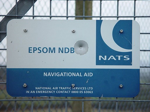
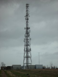
The mast marked on the OS map above also appears on the 1960 edition but I suspect that, in both cases, this is the much larger telecoms mast that sits next to the NDB.
Flap40,
Thanks for that. I was looking at GE and thinking “That’s a really big NDB mast!”
Thanks for that. I was looking at GE and thinking “That’s a really big NDB mast!”
Gnome de PPRuNe
Join Date: Jan 2002
Location: Too close to Croydon for comfort
Age: 60
Posts: 12,620
Received 294 Likes
on
162 Posts
I had no idea what an NDB looked like (I'm familiar with the VORs at Biggin, Seaford and - slightly bizarrely - Lands End...) so assumed the mast visible on Google was it. Bit of Googling shows me an NDB mast is slightly less substantial.

I vaguely recall it was moved to its present position sometime after 1980 having neen notified as 'withdrawn' for a short time. At one time the coding was 'EPS' not EPM' and I suspect (stand to be corrected) may have been changed when it moved.
The co-ordinates quoted above seem to be OSGB 36 notation and not WGS 84 but I'm sure that change didn't happen until late '90s.
The co-ordinates quoted above seem to be OSGB 36 notation and not WGS 84 but I'm sure that change didn't happen until late '90s.
It was 'EPM' on this 1968 approach plate: https://www.vc10.net/History/Images/...B28L_epsom.jpg
Join Date: Aug 1999
Location: Too Far North
Posts: 1,106
Likes: 0
Received 0 Likes
on
0 Posts
Some digging...
I've used this chart from 1960ish at https://atchistory.wordpress.com/202...ow-atc-part-2/ and also taken the variation of 7w as given on the Jepp chart.
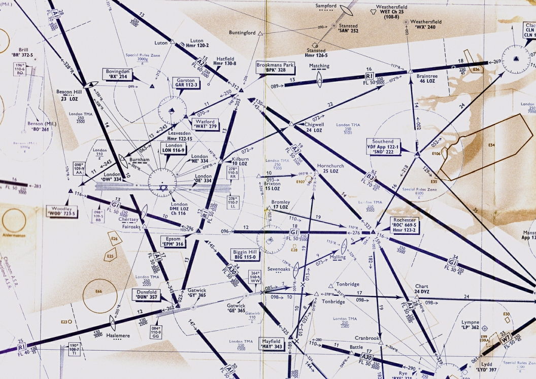
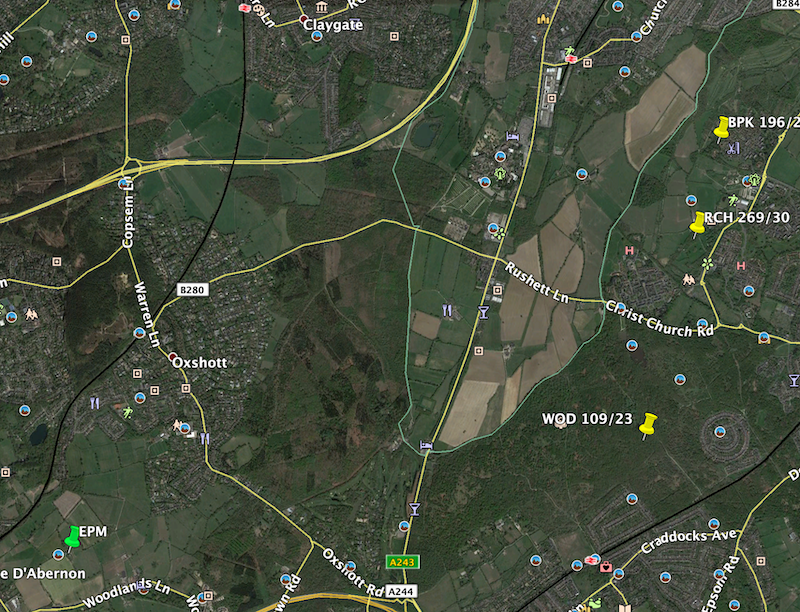
Plotting a three way fix from Brookmans park, Woodley and Rochester (and assuming none of those moved before 1991) gives a fairly wide spread but the general consensus seems to be somewhere about 3nm ENE of the current site.
Google earth clip below with the three plots in yellow and the current position in green.
I've used this chart from 1960ish at https://atchistory.wordpress.com/202...ow-atc-part-2/ and also taken the variation of 7w as given on the Jepp chart.
Plotting a three way fix from Brookmans park, Woodley and Rochester (and assuming none of those moved before 1991) gives a fairly wide spread but the general consensus seems to be somewhere about 3nm ENE of the current site.
Google earth clip below with the three plots in yellow and the current position in green.
Join Date: Aug 1999
Location: Too Far North
Posts: 1,106
Likes: 0
Received 0 Likes
on
0 Posts
@ Flap40: variation 7� would date the chart to late 60s or early 70s. From the UK Air Pilot COM section, page date 21/11/69. Note that the format for longitude omits the leading zero:
