


SWA147 approach at LGA 23Mar24

Thread Starter
Join Date: Oct 2022
Location: USA
Posts: 15
Likes: 0
Received 0 Likes
on
0 Posts
SWA147 approach at LGA 23Mar24
This is an interesting exchange...
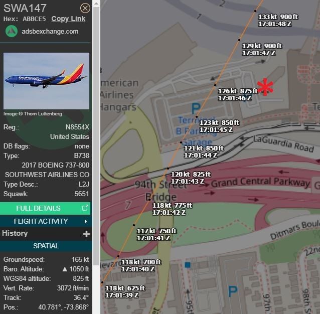
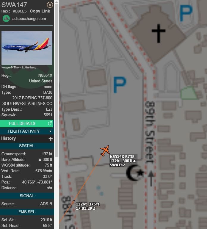
Southwest Boeing 737-8H4 (N8554X) performing flight SWA147 from Nashville to LaGuardia was on the second attempt to land when the aircraft suddenly deviated to the right of the approach path coming dangerously close to the control Tower at around 150-200 feet height.
Air traffic controller yelled the pilots to go around and climb immediately.

Based ADS-B data, aircraft passed just to the NW of the tower at a pressure-corrected altitude of 1030 ft, which would give a 790 ft vertical clearance with the 240 ft tower.
 found the 29.79 QNH on the audio recording
And a Topgun style (the movie) lateral separation.
Whoever kicked the crew back into reality, did a great job!
But it's another tower I would be more worried about (although this one, most likely, had no people residing in it).
They were really aiming for 'The Korean Church of Queens' with its 60ish feet tower+cross, with a positive RoC only just about to kick in.
And laterally, within a wingspan or so... even too close for Maverick
Last edited by DIBO; 27th Mar 2024 at 02:20.

Just throwing this out there. The ILS to Rwy 4 at LGA has a note on the approach plate prohibiting auto-pilot coupled approaches. Hence the pilot was hand flying, which could explain why they got so far off the localizer course. Challenging weather for a hand flown approach. Hopefully the most experienced pilot was the one flying it.
Just throwing this out there. The ILS to Rwy 4 at LGA has a note on the approach plate prohibiting auto-pilot coupled approaches. Hence the pilot was hand flying, which could explain why they got so far off the localizer course. Challenging weather for a hand flown approach. Hopefully the most experienced pilot was the one flying it.
Say what? There is no excuse for being so far off the localiser or G/S if you are flying manually.
By the time they were abeam the app.lights, they were some 9+degrees off localiser centerline, approx. 450m from the centerline
And only just about to start the G/A (some 400ft above rooftops)
And only just about to start the G/A (some 400ft above rooftops)
Only half a speed-brake
Many companies have formalized limits for pilots when it becomes mandatory to stop pushing and go around. Am I wrong to suppose SWA has those too, namely after skidding over at Burbank twice? That's a lot of practical experience.
The other thing that springs to mind, long lost information from the ATPL books, is that LLZ 1 dot deviation at RWY THR marks the physical runway edges. Thus LOC antenna placement (in terms of distance behind the THR) is defined by the spread angle and the sideline anchor points for 1 dot at THR.
Any armchair investigator can take Google maps now (or AIP data from US equivalent), locate the antenna and draw the protection area of 1 dot LLZ. In general I believe, again - ready to be re-educated -, 1 dot LLZ marks the acceptable range of being "on course" i.e. within the qualified lateral protection zone to follow the GP.
Pegase Driver
Join Date: May 1997
Location: Europe
Age: 74
Posts: 3,690
Likes: 0
Received 0 Likes
on
0 Posts
Besides the deviation, low height AGL, etc, it is another interesting non standard R/T , luckily the go around and climb "order" by the TWR was performed by the right aircraft.
Localizer is 700 feet wide at threshold, standard.
Long and wide, short and skinny, both adjusted to 700 feet wide. Third of a dot is autoland limit on my jet. That's 58'. On visuals, SOP is lateral confines NLT 200'.
A good read-
https://code7700.com/ils.htm#section3
Long and wide, short and skinny, both adjusted to 700 feet wide. Third of a dot is autoland limit on my jet. That's 58'. On visuals, SOP is lateral confines NLT 200'.
A good read-
https://code7700.com/ils.htm#section3
Last edited by moosepileit; 30th Mar 2024 at 16:10.
Join Date: Dec 2018
Location: Florida
Posts: 247
Likes: 0
Received 0 Likes
on
0 Posts
Just throwing this out there. The ILS to Rwy 4 at LGA has a note on the approach plate prohibiting auto-pilot coupled approaches. Hence the pilot was hand flying, which could explain why they got so far off the localizer course. Challenging weather for a hand flown approach. Hopefully the most experienced pilot was the one flying it.
So here's my question... if the GS signal is degraded to the point that modern autopilot can get spurious information, then why is the information provided by the GS valid for a hand flown approach?
I think it's time of the NY Port Authority, the FAA and the airlines to buy the Avion Hotel and tear it down!
The ILS 04 has always been a troublesome approach, going back decades. An FAA DC-3 Flight Check crashed testing back in the early ‘70s. Lots of buildings, hangars, the piers all make it problematic. The mins used to be about 400-1, now they’ve figured out a way to get them slightly lower. When it was 400-1, the reported weather would be 200 or 300 and mile, everybody would be getting in. An old squadron mate who was a B727 captain at the time told me it was “the most cheated on approach in the country”.
Of course, ceiling wasn’t governing, but it is indicative.
Of course, ceiling wasn’t governing, but it is indicative.
Only half a speed-brake
Localizer is 700 feet wide at threshold, standard.
Long and wide, short and skinny, both adjusted to 700 feet wide. Third of a dot is autoland limit on my jet. That's 58'. On visuals, SOP is lateral confines NLT 200'.
A good read-
https://code7700.com/ils.htm#section3
Long and wide, short and skinny, both adjusted to 700 feet wide. Third of a dot is autoland limit on my jet. That's 58'. On visuals, SOP is lateral confines NLT 200'.
A good read-
https://code7700.com/ils.htm#section3
I interpret half-scale to be 1 dot out of 2 on my ship.
However that cannot be pinpointed to RWY edge if the full LLZ beam 2.5 is 700 feet wide.
Noted. For a 60m wide runway it does come reasonably close to pavement edge at least.
Join Date: Dec 2018
Location: Florida
Posts: 247
Likes: 0
Received 0 Likes
on
0 Posts
So I am truly curious about this...from the ILS approach plate runway 4 KLGA..."Autopilot couple approach NA."
So I ask again... if an ILS GS signal isn't good enough for the electronics, why is it good enough for a hand flown approach?
So I ask again... if an ILS GS signal isn't good enough for the electronics, why is it good enough for a hand flown approach?
Thread Starter
Join Date: Oct 2022
Location: USA
Posts: 15
Likes: 0
Received 0 Likes
on
0 Posts
An autopilot would instantly jump on each one of those deviations.
I've not done that approach myself, but that's how it was explained to me by someone that has.
Last edited by GregAmy; 1st Apr 2024 at 16:13. Reason: typo
Join Date: Jun 2014
Location: Village of Santo Poco
Posts: 870
Likes: 0
Received 0 Likes
on
0 Posts
False ILS
As an ex Radio Engineer, the fact that he was quite a bit to the right of the Hotel, suggests he was following a False ILS Signal. This would be produced by diffraction of the ILS Signal. Effectively the hotel was broadcasting it's own ILS signal, because of the reflective nature of the components of the hotel construction.