


21st century instrumentation

THUNDERTAILED
Thread Starter
Join Date: Nov 1999
Location: L200
Posts: 325
Likes: 0
Received 0 Likes
on
0 Posts
21st century instrumentation
The recent Air Asia crash and, rightly or wrongly, comparisons to AF447 set me thinking.
Modern 21st century electronics have made it possible for amazing advances to be made in nearly all spheres or our lives. Aircraft fall behind because the pace of innovation far exceeds the speed of the certification processes required. Consequently aviation lags by years which these days represents a massive leap, sometimes by several orders of magnitude. This shortcoming will certainly be compounded in the future, in almost as exponential a fashion as the electronics are improving.
Totally new methods of doing many things are now possible, with well entrenched processes being thrown out on their ear and replaced by some newer, simpler and more effective technologies.
Consider aircraft instrumentation, based on pitot static systems which are prone to icing and other failures.
Would it not be possible to mount sets of accelerometers and GPS receivers at each extremity of the aircraft (wingtips, nose, tail) and thus be able to calculate the aircraft's true attitude in space, which could be displayed to the pilots as a 3rd person view? Without any pitot static information?
Instead of the INS's being located in one part of the aircraft and thus only able to calculate the position of the aircraft as a whole, with an inertial unit at each extremity the position of each extremity could be calculated and thus pitch, roll and yaw could be discovered. Almost like the position of four aircraft flying in very close formation.
in a calamity such as AF447 instead of the pilots being presented with conflicting, incorrect data and various alarms, a picture of the aircraft (in this case) falling through space with high nose up attitude could be displayed, clarifying the situation to the crew.

Join Date: Mar 2006
Location: USA
Posts: 2,515
Likes: 0
Received 0 Likes
on
0 Posts
The issue of GPS for attitude information usually comes up after an accident. While GPS is good, it isn't good enough to be used as an accurate source of attitude information.
Join Date: Oct 2008
Location: LAX
Posts: 68
Likes: 0
Received 0 Likes
on
0 Posts
We use pressure altitude for a reason in that it correlates to aerodynamic performance, which is critical at each end of the performance envelope. So I won't go so far as to advocate using absolute GPS altitudes, no matter how accurate, as filed/directed altitudes for flight.
Now, that said, the idea of using such GPS data, assuming it is EXTREMELY accurate (i.e. +- about 6 inches), presents some intriguing possibilities as another source of data for pilots to determine attitude. I'm not an expert on this, but when flying pitch/thrust in an emergency, I doubt GPS has the ability yet to provide information with the precision required. However, it does have the potential to present an indication of extreme vertical speed, which would be valuable data to have in an upset. If we can get GPS data accurate enough to provide attitude data accurate enough upon which we can rely, it would be a good tool to have in the toolbox.
IOW, a thoughtful idea, but one which I question whether the tech is yet up to the task.
I'd be pleasantly surprised if someone can chime in and prove to me that my assumptions regarding accuracy are incorrect.
Join Date: Jan 2001
Location: UK
Posts: 2,044
Likes: 0
Received 0 Likes
on
0 Posts
Would it not be possible to mount sets of accelerometers and GPS receivers at each extremity of the aircraft (wingtips, nose, tail) and thus be able to calculate the aircraft's true attitude in space, which could be displayed to the pilots as a 3rd person view? Without any pitot static information?

Join Date: Mar 2004
Location: Oxfordshire
Age: 54
Posts: 470
Likes: 0
Received 0 Likes
on
0 Posts
Ultimately an aircraft flies through the air, and it's behaviour relative to the mass of air needs to be measured. How will inertial or GPS data provide instantaneous airspeed?
Join Date: Aug 2009
Location: all over
Posts: 135
Likes: 0
Received 0 Likes
on
0 Posts
Great post for a discussion.
Yes, agree that the traditional pitot/static system is critical as it relays information required for aircraft performance. However, in the event of icing or system failure GPS information (if somehow made available) could save the day.
I don't buy the comment about the GPS system not being accurate enough - currently for GPS equipped aircraft, we can fly an RNAV approach with an RNP of as low as 0.3. 0.3NM!!! How is that not accurate enough??
In the event of a pitot/static system failure and/or unreliable airspeed, we can use the GPS groundspeed and wind information to help us. Furthermore, if they made the GPS altitude information available, though it would give us our true altitude - not pressure altitude or altitude corrected for temperature - it can give us enough information to respond accordingly. In such an extreme situation as complete pitot/static failure, even the trend (i.e. is the aircraft climbing or descending) would be enough for pilots to respond properly.
All the technology is there and available - just a matter of certification and getting through the red tape.
Join Date: Aug 2012
Location: United Kingdom
Age: 34
Posts: 948
Likes: 0
Received 0 Likes
on
0 Posts
0.3 NM is still considerably larger than the size of any airplane ever constructed. So unless you can get the receivers to know where they are in relation to the other ones on the aircraft, you would never be able to determine 3 axis data from it.
Guest
Join Date: Apr 2009
Location: On the Beach
Posts: 3,336
Likes: 0
Received 0 Likes
on
0 Posts
flapsupdown:
Make that RNP 0.10 for most modern air carrier airplanes.
I don't buy the comment about the GPS system not being accurate enough - currently for GPS equipped aircraft, we can fly an RNAV approach with an RNP of as low as 0.3. 0.3NM!!! How is that not accurate enough??
Join Date: Apr 2008
Location: The sunny side
Posts: 39
Likes: 0
Received 0 Likes
on
0 Posts
Unfortunately GPS/INS derived information does not provide all the information supplied by the air sensors on the aircraft to allow the aircraft to be flown safely, as aircraft fly relative to the airmass around them.
These sensors (pitot/static, Angle of Attack (AoA), Total Air Temperature (TAT)) provide information on what the aircraft is experiencing in the airmass it finds itself in. They are the only means to provide information that can be used by the automation or crew to determine if the aircraft is flying within its flight envelope (such as Airspeed, AoA, max pressure altitude). No GPS/INS sensor can do this.
Furthermore, aircraft instruments are calibrated for the ICAO standard atmosphere - to ensure that all aircraft fly to the same standard and so there are no conflicts due to altitude. This 'standard atmosphere' is based on pressure altitude and other compensations (such as temperature). It would take a significant global effort to change the concept of the ICAO standard atmosphere to mean GPS altitude, including changing the equipment fitted to every airworthy aircraft in the world.
Join Date: Jan 2001
Location: UK
Posts: 2,044
Likes: 0
Received 0 Likes
on
0 Posts
Yes, agree that the traditional pitot/static system is critical as it relays information required for aircraft performance. However, in the event of icing or system failure GPS information (if somehow made available) could save the day.

Attitude Information is critical - without it we will (in IMC) quickly lose control. Speed is not critical - we can fly all day without it. Altitude / vertical speed depends on circumstances, and certainly loss of Airspeed and Altitude is an issue. However, we do already have GPS altitude as a (somewhat poor) substitute for baro altitude.
What is as critical as Attitude is maintaining lift, which in turns requires an AoA approximation. Hence if we set an appropriate attitude, and have level flight, we know AoA. Or put another way - fly level, and adjust power to get an approximate attitude, we are safe. The basis for any loss of ASI drill.
Trouble is the modern airline environment does not teach or practice attitude flying, but "chasing the Flight Director" and pretending that is Manual Flying

So you say, why not substitute GPS speed for ASI? Well fine, it tells us our speed over the ground, but has zero relevance to lift. Particularly since most of these ASI events seem to icing / CB related, where W/V alters dramatically. At heart is it better to have a "best guess" speed displayed that may well be dangerously wrong? Or remove the "invalid info" and make clear to the pilot it is invalid and they'd better make alternative arrangements.
I am firmly of the belief that "removing" dubious or invalid info is far safer than trying to cobble together a best guess. A read of the AF447 report, and any modern tech manual, I would venture to say shows manufacturers and certification bodies think likewise.
Go back to AF447. Lost ASIs. Had it just been flown level for a short while, ASIs would have reappeared, plug AP back in, carry on. We need to somehow (re)acquire those basic skills.
I reckon most aircraft, setup in the pattern without ASIs, at ~5nu will fly fine (clean), now reduce power, and when attitude hits ~7-8nu take a stage of flap. Will now need return to 3-5nu to fly level and slow again for next stage of flap when required.
When I, or my colleague are practicing a FDs off approach, it is noticeable that typically my colleague will call flaps purely with regard to the speed annotations (GD, S, F etc.). If the attitude for level flight gets high, and/or there is turbulence, or a turn / level off if I suggest some Flap there is complete confusion as to my concern - even though Alpha Prot has come up

THUNDERTAILED
Thread Starter
Join Date: Nov 1999
Location: L200
Posts: 325
Likes: 0
Received 0 Likes
on
0 Posts
It may be that current technology is not up to the task we're discussing, but it may just be though. If not now, certainly soon. But now it should be good enough to give the crew decent gen in a calamity than the current state of the art, as emergency data?
Don't just put GPS unit on the extremities, put IRS units there too. I know its hardly a comparison to what will be needed, but imagine an iPhone on each wingtip, the nose and the tail. The accelerometer data is not for navigation, so 0.3 ANP etc isnt relevant. It's for attitude info only, realtime. The more accurate the GPS the better, and each system would complement the others and make it even more accurate.
Lets think a bit about this, we need..
EADI - derive attitude from the system I'm talking about (lets call it 3AE, 3 axis at extremities)
VSI - derived from GPS
ALT - derive from GPS
HDG - derive from GPS
ASI - derive anticipated airspeed (ie. What it would be if not acted upon by wind gusts) by calculating what airspeed should be at calculated attitude with known thrust setting at given altitude (temp you'll need a probe). Mach data by referring to temp and TAS (more about which to come!)
To adjust for immediate windspeeds, possibly use very accurate doppler radar which will reveal the speed of water particles in the air in the case of 'wet gusts' , and to measure the speed of dry gusts, the aircraft could issue a high pitched sound of a given frequency from the nose, receive it in the tail and wingtips, and using doppler effect calculations by comparing the frequency difference at reception could determine the speed of the air passing by the aircraft, like hearing a whistling train go by. I'm not sure how mach compressibility effects might upset this, perhaps someone here does.
Because a gust will not hit all parts of the aircraft simultaneously, if the 3AE system is accurate enough it would be able to compare how the airframe has responded in realtime to a database of known possibilities. Very very simplistically, if the left wing lifts suddenly before the right, and the aircraft then yaws left more than is usual and climbs, it compares it to the database test data which says, yes, that gust was from X bearing and direction. Speed of gust calculated by micro-time between motions of extremities.* We're talking vast computer power here, but it is available. The latest mobile phone chip can do a teraflop of throughput, which is what the worlds fastest supercomputer could do in 2000, only 14 years ago.
Combining these different results with each other will make the final result more accurate, as will analysing instantaneous changes in groundspeed (GPS) and adding that to the mix. The clues are all there, we just have to link them all up like a high speed detective case. Sounds silly but thats essentially what it is.
There we have our blind flying instruments back.
We know the crew shouldn't be faced with conflicting data and spurious alarms. If crucial data is lost, or if the data falls in the defined to be rubbish category, the computer needs to make up for its loss and not either just jack it in or pull some dangerous kneejerk move. At worst it needs to do nothing and display "Stand by!" leave all controls in last setting including engine controls, and display the known required pitch attitude on the EADI for that power setting for level flight at the aircraft's altitude and weight until the crew make a decision and intervenes, or good data returns.
The 3AE system could display the aircraft from a 3rd person view, in 3D as a friend of mine on here recognised. The pilots could watch themselves spinning. (Airline livery obviously a manufacturer extra!) You could even view yourself landing it from a lateral perspective. Its really now just a big computer game with a real plane attached, all the data is there, we just couldnt use it before because it took such processing power, and such accurate instruments. It may not surprise some of you that nowadays its possible to take photographs at a rate of one trillion frames a second, fast enough to freeze a photon. There's yet another solution to the no pitot tube problem - measure the progress of particles in the airstream using this technology...we're back to casting a log overboard and measuring the knots
Last edited by AfricanSkies; 5th Jan 2015 at 16:37. Reason: small clarification re TAS
Sorry to butt in but I distinctly remember reading a flight test report where they used differential GPS to determine attitude.
Something like this:
Space flight tests of attitude determination using GPS - ResearchGate
Something like this:
Space flight tests of attitude determination using GPS - ResearchGate
THUNDERTAILED
Thread Starter
Join Date: Nov 1999
Location: L200
Posts: 325
Likes: 0
Received 0 Likes
on
0 Posts
Thanks for that link. So they have done it already  dI'd like to read the full article but it seems you have to register. Amazing isn't it, sub centimeter accuracy! And here we are cutting the edge with 0.03 ANP
Another thing that I'd like to think would be useful is a Vref call out, maybe we can apply for that instead?
dI'd like to read the full article but it seems you have to register. Amazing isn't it, sub centimeter accuracy! And here we are cutting the edge with 0.03 ANPAnother thing that I'd like to think would be useful is a Vref call out, maybe we can apply for that instead?
Join Date: Jun 2008
Location: Cambridge UK
Posts: 192
Likes: 0
Received 0 Likes
on
0 Posts
Amazing isn't it, sub centimeter accuracy! And here we are cutting the edge with 0.03 ANP
0.03 ANP relates to an absolute GPS position.
Differential GPS is always going to be a lot more accurate, as lots of error mechanisms cancel out (e.g. variable ionospheric effects).
Join Date: Aug 2012
Location: Wales
Posts: 532
Likes: 0
Received 0 Likes
on
0 Posts
I am not to sure that the inbuilt error of each wing-tip GPS will be the same, unless they are synchronised together.
At the moment I have my GPS telling me where my car is (it's parked on the drive outside the house.) and it has given readings of 55,44,40,43,50... feet away.
So what sort of calculations can you do if the Starboard-Wing GPS cannot accurately measure where Port-Wing GPS is.?
At the moment I have my GPS telling me where my car is (it's parked on the drive outside the house.) and it has given readings of 55,44,40,43,50... feet away.
So what sort of calculations can you do if the Starboard-Wing GPS cannot accurately measure where Port-Wing GPS is.?
Join Date: Jan 2001
Location: UK
Posts: 2,044
Likes: 0
Received 0 Likes
on
0 Posts
ASI - derive anticipated airspeed (ie. What it would be if not acted upon by wind gusts) by calculating what airspeed should be at calculated attitude with known thrust setting at given altitude (temp you'll need a probe). Mach data by referring to temp and TAS (more about which to come!)
To adjust for immediate windspeeds, possibly use very accurate doppler radar which will reveal the speed of water particles in the air in the case of 'wet gusts' , and to measure the speed of dry gusts, the aircraft could issue a high pitched sound of a given frequency from the nose, receive it in the tail and wingtips, and using doppler effect calculations by comparing the frequency difference at reception could determine the speed of the air passing by the aircraft, like hearing a whistling train go by. I'm not sure how mach compressibility effects might upset this, perhaps someone here does.
To adjust for immediate windspeeds, possibly use very accurate doppler radar which will reveal the speed of water particles in the air in the case of 'wet gusts' , and to measure the speed of dry gusts, the aircraft could issue a high pitched sound of a given frequency from the nose, receive it in the tail and wingtips, and using doppler effect calculations by comparing the frequency difference at reception could determine the speed of the air passing by the aircraft, like hearing a whistling train go by. I'm not sure how mach compressibility effects might upset this, perhaps someone here does.
 If you presented this rather complex solution, with numerous inputs all liable to failure and error, I am sure the boffins would listen carefully... and then one would say "but we could just stick a tube into the air facing forwards?"
I'm really not sure why this pressure for a GPS derived "attitude"? Modern INS units are amazingly reliable, we have 3 of them, and even after internal failures, the attitude function is retained. Whereas any GPS derived solution is vulnerable to Uncle Sam just throwing the switch, and/or jamming? Can you think of a modern airliner accident caused by an attitude display fault? Since the STN 747 which was a mechanical instrument, and even then, the other 2 indicators were fine IIRC?
PS I think your Doppler thing will only work when the tail falls off

Join Date: Mar 2001
Location: I wouldn't know.
Posts: 4,497
Likes: 0
Received 0 Likes
on
0 Posts
Don't just put GPS unit on the extremities, put IRS units there too. I know its hardly a comparison to what will be needed, but imagine an iPhone on each wingtip, the nose and the tail. The accelerometer data is not for navigation, so 0.3 ANP etc isnt relevant. It's for attitude info only, realtime. The more accurate the GPS the better, and each system would complement the others and make it even more accurate.
Attitude information is not the problem, flying the correct attitude is.
And differential gps is all nice and dandy, but it usually requires ground equipment in a short range. Google GBAS and have a read of a real world approved and certified differential gps application in aviation.
As I understand it, which isn't saying much, but you only need a ground station for DGPS if you you need pin point accuracy in relation to the ground, as in a GPS approach.
For monitoring attitude for an aircraft, the base station would be on the aircraft.
For monitoring attitude for an aircraft, the base station would be on the aircraft.

Join Date: Aug 2013
Location: PA
Age: 59
Posts: 30
Likes: 0
Received 0 Likes
on
0 Posts
Wow.
A few issues broaught up...
1. Pitot tubes, there are at least 2 one in the front facing forward, and one in the rear facing backwards to airflow. The resultants are coupled.
2. DGPS does rely on ground stations, and is very localized. One must understand that DGPS corrects to the WGS84 ellipsoid model. It is accurate to that model. That model is an approximation of the Earth, so in effect it is accurate to an approximation, which, while getting better, has issues with the bulge of the Earth, especially in the northern/southern latitudes. In addition, I have seen little information on the broadcast range that would make this viable for aviation.
3. As noted before in other threads, the GPS tells the aircraft where it was, not where it is. The Kalman filter is used to estimate where the aircraft is. Due to latency in the GPS signal itself, onboard processing, and other issues, the Kalman filter is required to estimate current position of the aircraft. For reference, a single GPS broadcast from one sat is about 3 seconds long, you need at least 6 for any accuracy, and the sats are not sync'd. Thus in effect, the INS, not the GPS is giving you the current position.
4. Altitude. Depending on the system architecture, the GPS is giving you altitude based on a reference from the horizontal position to the WGS 84 geodetic/ellipsoid. Some units calculate altitude based on actual calculations to the ellipsoid, while others have a simplistic grid placed over the geoid, with a lookup feature. This is more accurate when flying a straight line (and from above) at a constant speed. The system is less accurate in turns, depending on how the individual system architecture calculates geoidal position in a turn. Again, as noted in other threads, the FAA procedure design software did not , and still does not, do a very good job of approximating location while the flightpath turns on an elliptical surface.
5. As Denti noted, GBAS/GLS capability. Localized ILS like guidance. Why this is not on every runway end, and on every aircraft, I just dont know. A failure of the regulatory system is about all I can determine.
Last edited by underfire; 6th Jan 2015 at 09:16.
Join Date: Jul 2013
Location: Maryland USA
Posts: 133
Likes: 0
Received 0 Likes
on
0 Posts
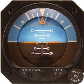
I must be totally missing something.
ATTITUDE is displayed by gyroscopic instruments.There is no need at all to put a GPS at each corner of an airplane.
Here are some examples of fine and dandy attitude indicators you can buy today
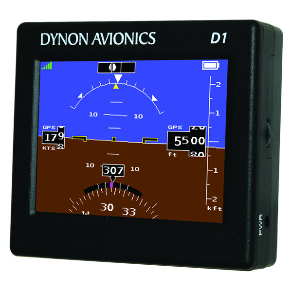
This one is even portable and shows GPS groundspeed too
ATTITUDE is displayed by gyroscopic instruments.There is no need at all to put a GPS at each corner of an airplane.
Here are some examples of fine and dandy attitude indicators you can buy today
This one is even portable and shows GPS groundspeed too