


UPS cargo crash near Birmingham AL


Close call!

Join Date: Jul 2013
Location: 12E CTY
Age: 69
Posts: 22
Likes: 0
Received 0 Likes
on
0 Posts
The topped trees were at spots 820 and 822. In my estimation, judging by the trees that were topped, the fuselage did indeed follow precisely that yellow line and passed directly over the house. I estimate the fuselage cleared the roof by 10-20 feet.
So they made contact with what appears to be the last trees before the cleared area.
Join Date: Jun 2001
Location: Rockytop, Tennessee, USA
Posts: 5,898
Likes: 0
Received 1 Like
on
1 Post
Would it be possible to enter an incorrect value for the MDA @IMTOY, e.g. typo 1-2-0 or 2-0-0 instead of 1-2-0-0, and the autopilot would try to fly that profile? What are the typical safeguards or controls to prevent an incorrect data entry?
one would think the constraint at IMTOY would have been in the database....many airlines SOPs prohibit modifying any portion of the final approach if it is to be flown managed...
The FMS database I have access to does not have IMTOY depicted, you would have to identify it with 3.3 DME off IBXO to go down to the 1250 feet D-DA.
With IMTOY missing from the FMS procedure you would never manually insert it inside the FAF at any place I've ever worked, as IB57 has said. However, if for some unknown reason you did, with say, a D-DA of 1250 instead of the published crossing altitude of 1380, I do believe you would get a new path that leads to touchdown well short of the runway. And the path would not just be lower, but steeper as well with the altitude constraints at BASKN and IMTOY. I would hope you would get some sort of error message since the path angle has changed with the erroneous entry, but perhaps not.
As pointed out previously, the IBXO DME reads 1.3 at the runway threshold, not zero so this might confuse the cross check when things don't look exactly right.
It is an absolute alphabet soup but I read the 'Only authorized operators may use VNAV DA (H) in lieu of MDA (H)' to mean that you can use the D-DA on the 3.28 degree path, if like presumably UPS, you are authorized.
The additional question of whether an incorrect entry of minimums on the approach page of the FMS would cause the autopilot to stay on lower than it should is a good one. Data entry on these legacy FMS boxes is arcane and archaic, sometimes you need a leading zero, a decimal point or a slant, sometimes you don't. And, subtle differences exist between similar looking FMS's on Boeings, Airbuses and MD's from what I've seen.
Last edited by Airbubba; 27th Aug 2013 at 18:38.
Join Date: Jul 2013
Location: Mosquitoville
Posts: 99
Likes: 0
Received 0 Likes
on
0 Posts
Quote: The topped trees were at spots 820 and 822. In my estimation, judging by the trees that were topped, the fuselage did indeed follow precisely that yellow line and passed directly over the house. I estimate the fuselage cleared the roof by 10-20 feet.
The utility pole on the left side of your picture is likely 820. That mail box is very close to the yellow line. The tree on the right (with the red tape around the base) may be 854.
So they made contact with what appears to be the last trees before the cleared area.
The utility pole on the left side of your picture is likely 820. That mail box is very close to the yellow line. The tree on the right (with the red tape around the base) may be 854.
So they made contact with what appears to be the last trees before the cleared area.
Join Date: Jul 2013
Location: USA
Posts: 31
Likes: 0
Received 0 Likes
on
0 Posts
Has anyone matched the snapped off tree(s) shown on #470 to the where that is on the Digital Global map w/the surveyed points ? The heavy foliage behind the tree(s) almost looks the group east of the Benson property, and north of the 851 survey.
#470 http://www.pprune.org/rumours-news/5...ml#post8001294
#470 http://www.pprune.org/rumours-news/5...ml#post8001294
The first match point is the leafless top of the skinny pointed tree to the right of the mailbox, with a single bare branch pointing left and a shorter one to the right. Zoom in and you can see the red tape on the trunk. This matches the tree to the left of pole 820 in the top photo in post #470 , but viewed from the opposite direction.
This same tree is visible in the lower photo of post #470 almost directly behind the mailbox. About 2/3 of the way up from the mailbox is a horizontal, yellowish leafy area that almost looks like a ring around the trunk. In Huck�s photo it is reddish, about halfway up the tree.
The other damaged trees in the upper photo are between tree 854 and the driveway. It is hard to get a reference for them due to perspective compression from the photo being taken with a telephoto lens. Tree 854 is off Huck�s photo to the right.
Damage to the trees is easier to see when compared with Google Street View which is here: http://goo.gl/maps/NWjw5 It may take a moment to load. Point 822 is the light pole on the south side of the road, with the light hanging out over the road.
Join Date: Jul 2013
Location: 12E CTY
Age: 69
Posts: 22
Likes: 0
Received 0 Likes
on
0 Posts
Anyone care to guess if the first impact noise on the CVR was the trees ?

Join Date: Aug 2013
Location: PA
Age: 59
Posts: 30
Likes: 0
Received 0 Likes
on
0 Posts
There are quite a few points in the UDDF file which are certainly not obstacles (note the catch basin in the road)
The ridge leading up to threshold would mask most of these points as well.
Here is the line on Google Earth

Here is the house with topped trees (note ridges beyond, also note eye level altitude of 808 feet, about 20 feet off ground surface alt.) This seems pretty close to where the aircraft was, and perhaps what they saw.

Ridge before threshold (note runway beyond)

The ridge leading up to threshold would mask most of these points as well.
Here is the line on Google Earth
Here is the house with topped trees (note ridges beyond, also note eye level altitude of 808 feet, about 20 feet off ground surface alt.) This seems pretty close to where the aircraft was, and perhaps what they saw.
Ridge before threshold (note runway beyond)
Last edited by underfire; 29th Aug 2013 at 19:39.
Join Date: Mar 2013
Location: huntsvegas
Posts: 41
Likes: 0
Received 0 Likes
on
0 Posts
Those are some interesting graphics. Mrs. Benson said she found pieces of aluminum on her back porch, and i have to wonder if tree contact was made earlier to do some initial damage, and then again at her trees to knock the parts loose.
Would you be able to extend the red line back about 3000 ft to where they may have been when the sink rate warning was issued to determine pilot's view and possible obstructions in the path toward the Benson house.
Would you be able to extend the red line back about 3000 ft to where they may have been when the sink rate warning was issued to determine pilot's view and possible obstructions in the path toward the Benson house.
Join Date: Jul 2013
Location: USA
Posts: 31
Likes: 0
Received 0 Likes
on
0 Posts
This is the house roughly 550 feet north of the Benson residence along the extended centerline. There is tree debris on the roof and if you zoom in you can see damage to the top of the tree on the right side of the photo. (from Before UPS Flight 1354 crash, tension between Birmingham airport and neighborhoods | al.com)

You can see the tree clearly (leafless) on my photomap http://www.m2ei.com/kbhm/northern_points.jpg
Here is another photo extending about 0.4 nm north from Benson's. The full size image is: http://www.m2ei.com/kbhm/benson_north_to_834.jpg

You can see the tree clearly (leafless) on my photomap http://www.m2ei.com/kbhm/northern_points.jpg
Here is another photo extending about 0.4 nm north from Benson's. The full size image is: http://www.m2ei.com/kbhm/benson_north_to_834.jpg
Join Date: Jun 2009
Location: NNW of Antipodes
Age: 81
Posts: 1,330
Received 0 Likes
on
0 Posts
The track below is part of a series I have been making to emulate the path taken by UPS 1354. The full detail will be posted some time in the next 24 hours, but how they came to be there is, to my mind, a mystery.

Join Date: Aug 2013
Location: PA
Age: 59
Posts: 30
Likes: 0
Received 0 Likes
on
0 Posts
Ridge before runway

House with clipped trees/powerlines

House shown in sardaks image

profile high point near house in sardaks image

I suggest looking at this hilltop as well.

EDIT for reference, the threshold is at 1.3mi on the profile

House with clipped trees/powerlines
House shown in sardaks image
profile high point near house in sardaks image
I suggest looking at this hilltop as well.
EDIT for reference, the threshold is at 1.3mi on the profile
Last edited by underfire; 30th Aug 2013 at 15:16.

Join Date: Dec 2006
Location: Florida and wherever my laptop is
Posts: 1,350
Likes: 0
Received 0 Likes
on
0 Posts
Originally Posted by Sardak
This is the house roughly 550 feet north of the Benson residence along the extended centerline. There is tree debris on the roof and if you zoom in you can see damage to the top of the tree on the right side of the photo.
Join Date: Sep 2010
Location: Florida, USA
Age: 77
Posts: 30
Likes: 0
Received 0 Likes
on
0 Posts
I bet it is not a mystery why they got that low to anyone who has seen the CVR transcripts... unfortunately the NTSB won't let the rest of us learn anything for months or years.
Ian W.;
Re, "So whatever the reason UPS 1354 was low, it may be common to other (unreported?) close calls "
A good FOQA Program will already have a form of "Early descent" or "Too Low 2 minutes before touchdown" or some variation of the event.
While such close calls may go unreported, (not very good safety culture behaviour), any FOQA Analyst who's doing his/her job will have ensured that the program has such events and that the results are routinely passed on to operations, flight safety, training/standards for corrective action. It is almost a certainty that this kind of event occurs in flight data.
Analysis takes a look at all factors including weather, ATC distractions, circadian time frame, precision or non-precision approach, etc and makes sure that that knowledge is passed on to the appropriate managers and that crew calls are made by the pilot group's FOQA representative (not the company) to understand more about such an event and to pass on the learning.
Join Date: Jun 2009
Location: NNW of Antipodes
Age: 81
Posts: 1,330
Received 0 Likes
on
0 Posts
@ underfire
Fine work on the profiles.
We actually know the track they took, due to photographic imagery of treetop damage. You have made your plots further to the west, and it would be interesting to see the generated terrain profile if you did the same again but on the meridian of 86� 44' 49.18"W.
Fine work on the profiles.
We actually know the track they took, due to photographic imagery of treetop damage. You have made your plots further to the west, and it would be interesting to see the generated terrain profile if you did the same again but on the meridian of 86� 44' 49.18"W.

Join Date: Aug 2013
Location: USA
Posts: 3
Likes: 0
Received 0 Likes
on
0 Posts
Rewind - Was any 18 approach legal...for aircraft in 'Height Cat 4'
Forget the flight path analysis for one minute and back up.
So a thread on another website quoted a FAA Joint Order that pertains to Visual Guidance Lighting Systems. I am asking if anyone else reads this the same way I do and therefore questions the legality of an A-300 size aircraft being filed/dispatched to a runway under IFR flight plan when the PAPI system was REQUIRED to be operational for either instrument approach to the operating runway BUT the PAPI system settings were NOT COMPLIANT with that size aircraft? However you interpret this, please respond.
----------------------
This gets really into the weeds and does not involve normal TERPS regs - I am NOT questioning the legality or obstacle clearance of either FAA instrument approach to runway 18. I am questioning why/how the approaches aren't restricted at night to aircraft that comply with the existing and mandatory PAPIs.
LOC and RNAV 18 have TCH of 48feet - Look at the last sentence of the second paragraph along with the required TCH for 'Height group 4' (A-300 specifically listed)
[IMG]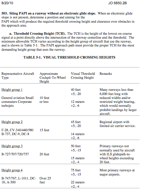 [/IMG]
Full FAA JO here:
http://www.faa.gov/documentLibrary/m...%206850.2B.pdf
So a thread on another website quoted a FAA Joint Order that pertains to Visual Guidance Lighting Systems. I am asking if anyone else reads this the same way I do and therefore questions the legality of an A-300 size aircraft being filed/dispatched to a runway under IFR flight plan when the PAPI system was REQUIRED to be operational for either instrument approach to the operating runway BUT the PAPI system settings were NOT COMPLIANT with that size aircraft? However you interpret this, please respond.
----------------------
This gets really into the weeds and does not involve normal TERPS regs - I am NOT questioning the legality or obstacle clearance of either FAA instrument approach to runway 18. I am questioning why/how the approaches aren't restricted at night to aircraft that comply with the existing and mandatory PAPIs.
LOC and RNAV 18 have TCH of 48feet - Look at the last sentence of the second paragraph along with the required TCH for 'Height group 4' (A-300 specifically listed)
[IMG]
 [/IMG]
Full FAA JO here:
http://www.faa.gov/documentLibrary/m...%206850.2B.pdf
Last edited by GGNP; 31st Aug 2013 at 03:23. Reason: Revised Title
Join Date: Jul 2013
Location: Charlotte, NC
Posts: 7
Likes: 0
Received 0 Likes
on
0 Posts
GGNP,
You have a point regarding the suitability for the A300 to use this runway at night, but it wasn't the cause of the low altitude and CFIT. My understanding is that the automation was controlling the airplane. If the autopilot was set to follow the VDA on the chart, they would have been much higher. It suggests that the autopilot was in a VS mode or the there was some other issue that permitted the autopilot to follow the lower profile. If the VGSI path was followed, the aircraft would not have impacted the trees where it did.
You have a point regarding the suitability for the A300 to use this runway at night, but it wasn't the cause of the low altitude and CFIT. My understanding is that the automation was controlling the airplane. If the autopilot was set to follow the VDA on the chart, they would have been much higher. It suggests that the autopilot was in a VS mode or the there was some other issue that permitted the autopilot to follow the lower profile. If the VGSI path was followed, the aircraft would not have impacted the trees where it did.
Excellent find on an interesting piece of information.
Using 3.2 deg angle and considering the difference of 27 ft (75ft -48 ft), the difference in touchdown point would shorten touchdown distance, perhaps, as much as 482 ft.
I'm not sure the VGSI TCH, in this case based on a standard for Airports PAPI siting, is necessarily intended to assure obstacle clearance (the topic of many interesting graphic submissions so far). Perhaps, I�m wrong on that. In any case we can surmise from the design of the LOC 18 procedure there are known obstacles in the visual segment, (e.g., no VDP).
I suggest that, as I think others have noted before, the "Sink Rate" alert, which does not trigger for less than 1000 FPM VVI (baro), and is heard on CVR approx 7 sec prior to sounds of impact, one could surmise the VVI was greater than 1000 FPM, perhaps 1100+ FPM. So, VVI must be a prime suspect until more data is forthcoming.
One could imagine the crew reacting quickly to the Sink Rate alert at least reducing the VVI in the last moments before impact. Again we must wait for the actual data. At approx. 140 kts, the airplane would travel 1,656 ft in 7 seconds. So does 1100+ FPM VVI make sense at that location in the approach? What could account for it?
Join Date: Mar 2013
Location: huntsvegas
Posts: 41
Likes: 0
Received 0 Likes
on
0 Posts
Autopilot versus Autothrottle
Would it be possible to get dominating or conflicting guidance, navigation or flight control commands due to the mode selection when using these automation/software functions at the same time?
i'm sure the software is under configuration management and control, and should be thoroughly tested and wrung out before updates are pushed out to the fleet, but software can be difficult.
For example in this incident the aircraft is flying at 140 knots in a stabilized approach and crosses IMTOY at the correct 1380 MSL altitude and on the 3.28 constant descent angle. Eleven seconds later it reaches the 1200 MDA (or 1250 D-DA), and the software takes action based upon the dominant mode to throttle back the engines and begin a very steep descent. Five seconds after that the sink rate warning is issued due to the high vertical speed. Everything seems to be working okay according to the software because that is what it is programmed to do. But the dominant mode may have issued a command that conflicts with the best interest of the aircraft's stability or safe operating during final approach.