


AF 447 Search to resume

mm43;
RTLU schematic below.
There are six "stops":
Rudder Pedal Stops - non-adjustable, which limit pedal maximum travel
Pedal Travel limitation unit - PTLU - limits maximum pedal command
Servocontrol input linkage fixed stop - limits masimum servocontrol command
Rudder travel Limitation Unit - limits the masimum input to the servo controls
Rudder Travel Stops - non-adjustable servocontrols stroke-end stops
Rudder Structural Stops - when servo controls are not installed
Note - There is no special stop between the rudder and the structure of the vertical stabilizer.
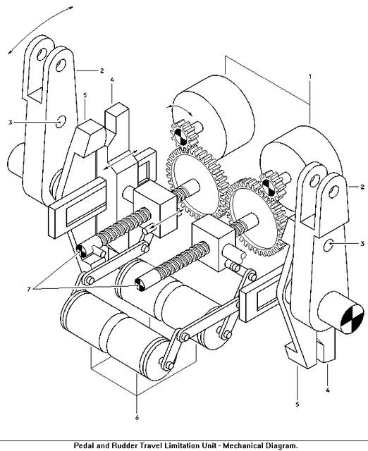
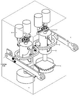
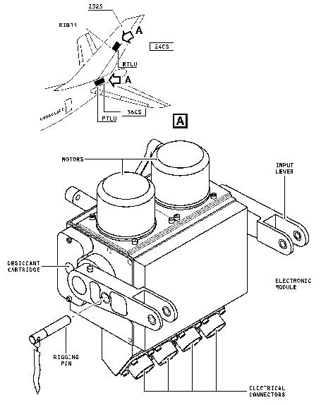
I haven't seen a schematic for the RTLU, but I suspect that a worm screw driven device creates a "feedback" position that inhibits hydraulic pressure to the operating rams beyond the set point. In this respect, the RTLU position is utilized by both port & starboard rams.
There are six "stops":
Rudder Pedal Stops - non-adjustable, which limit pedal maximum travel
Pedal Travel limitation unit - PTLU - limits maximum pedal command
Servocontrol input linkage fixed stop - limits masimum servocontrol command
Rudder travel Limitation Unit - limits the masimum input to the servo controls
Rudder Travel Stops - non-adjustable servocontrols stroke-end stops
Rudder Structural Stops - when servo controls are not installed
Note - There is no special stop between the rudder and the structure of the vertical stabilizer.
Last edited by PJ2; 10th Aug 2010 at 23:41. Reason: Getting the sizes right

Join Date: Jun 2009
Location: NNW of Antipodes
Age: 81
Posts: 1,330
Received 0 Likes
on
0 Posts
The following is an extract from the Phase 3 Search Area Determination Report:-
Figure A7_1 below shows the cusp shaped spot detected, which does not have the characteristic elongated form of an oil spill coming from a ship. CLS and CEDRE experts were not able to understand its origin. Report by G. Hajduch, P. Lozach & F. Collard gives other SAR images with well-identified signatures from ship tracks and oil spills.

A 330 m wavelength swell (propagating southward) is also visible (the SAR resolution is 30 m). We have seen in chapter II (section on particle trajectories), that the back track (to June 1 at 2h15) of this pollution spot falls (within one or two kilometres) under the plane flight line roughly 10 nautical miles south southwest of LKP (one minute of flight time). This prompted us to check if such a spot could correspond to some kerosene (aviation fuel) released by the plane.
Within a few minutes after release, kerosene spreads on the sea surface as a very thin layer of the order of 1 �m (actually between 0.05 and 5 �m; the uncertainty is large). After 30 hours kerosene will have evaporated and dispersed[26] almost completely: with an initial amount of 50 m3 there would remain (with a 10 knots wind) roughly 0.5 m3 for a SAR detection. The estimated area of the spot on Figure A7_1 is approximately 0.5 km2 and that would correspond to a layer 1�m thick at most. Knowing that some 43 000 kg of kerosene were still in the plane tanks after its 3h 40 mn flight (Rio to LKP), thus roughly 54 m3 (kerosene density is 0.8 kg dm-3), it is not impossible that this pollution spot may be the remnant of a kerosene release by the plane (be it voluntary or not). Of course it is difficult to tell which quantity is precisely involved (it may vary between 3 m3 and the whole 54 m3).
A last point concerns the wind drag on the spot as a whole: generally, 3% to 4% of the wind speed is assumed for oil (CEDRE, 2004). On Figures 25 and 27 we took 0% and 2% respectively (kerosene is light and volatile and has possibly a smaller wind drag than oil). The greater the windage the nearer the back tracked position to LKP since winds were northerly, but the nearest to the plane track is obtained with a 2% wind drag (whence our choice). Over only 30h we could expect a small distance between positions estimated with a 1% drag difference: there is however a 5 km distance (slanted in a SW-NE direction, see Figure A5_2) because the wind was strong then.
We have been unable, however, to relate this pollution spot to any impact point of the plane as determined from the debris and bodies found and the velocity fields estimated (whatever the methods). But, all our calculations, are based on the assumption that the plane hit the sea surface intact (following BEA expertise of the recovered plane remains).
NOTE:[26] breaking waves can drive small droplets into the water column. This process is called dispersion (Lehr & al., 2002)
-------------------------------------
This "oil-slick" can not be discounted, bearing in mind that the modeling which resulted in the Phase 3 Search Area, has so far not provided a result. My initial reaction to this information was that if it wasn't kerosene, it could possibly have been a short-lived algae bloom. Those blooms are more likely to be found in coastal waters where land based run-offs provide nutrients to trigger them.
Machinbird and GreatBear have both postulated (with different reasons) that the crash spot may be closer in to the LKP than had been assumed. Obviously, further research and modeling may bring this oil-slick and its location into sharper focus.
EDIT:: "... experts were not able to understand its origin" - that alone is cause for further investigation?????
mm43
Appendix 7: a SAR detected pollution spot
On June 2 2009 at 8h16, a possible pollution spot was detected near 30�30.5�W 2�43.4N by the synthetic aperture radar (SAR) on board the COSMO SkyMed 1 satellite. Figure A7_1 below shows the cusp shaped spot detected, which does not have the characteristic elongated form of an oil spill coming from a ship. CLS and CEDRE experts were not able to understand its origin. Report by G. Hajduch, P. Lozach & F. Collard gives other SAR images with well-identified signatures from ship tracks and oil spills.
Figure A7_1
Cusp-shaped pollution spot seen on a COSMO SkyMed SAR image (on June 2 2009 at 8h16).
A 330 m wavelength swell (propagating southward) is also visible (the SAR resolution is 30 m). We have seen in chapter II (section on particle trajectories), that the back track (to June 1 at 2h15) of this pollution spot falls (within one or two kilometres) under the plane flight line roughly 10 nautical miles south southwest of LKP (one minute of flight time). This prompted us to check if such a spot could correspond to some kerosene (aviation fuel) released by the plane.
Within a few minutes after release, kerosene spreads on the sea surface as a very thin layer of the order of 1 �m (actually between 0.05 and 5 �m; the uncertainty is large). After 30 hours kerosene will have evaporated and dispersed[26] almost completely: with an initial amount of 50 m3 there would remain (with a 10 knots wind) roughly 0.5 m3 for a SAR detection. The estimated area of the spot on Figure A7_1 is approximately 0.5 km2 and that would correspond to a layer 1�m thick at most. Knowing that some 43 000 kg of kerosene were still in the plane tanks after its 3h 40 mn flight (Rio to LKP), thus roughly 54 m3 (kerosene density is 0.8 kg dm-3), it is not impossible that this pollution spot may be the remnant of a kerosene release by the plane (be it voluntary or not). Of course it is difficult to tell which quantity is precisely involved (it may vary between 3 m3 and the whole 54 m3).
A last point concerns the wind drag on the spot as a whole: generally, 3% to 4% of the wind speed is assumed for oil (CEDRE, 2004). On Figures 25 and 27 we took 0% and 2% respectively (kerosene is light and volatile and has possibly a smaller wind drag than oil). The greater the windage the nearer the back tracked position to LKP since winds were northerly, but the nearest to the plane track is obtained with a 2% wind drag (whence our choice). Over only 30h we could expect a small distance between positions estimated with a 1% drag difference: there is however a 5 km distance (slanted in a SW-NE direction, see Figure A5_2) because the wind was strong then.
We have been unable, however, to relate this pollution spot to any impact point of the plane as determined from the debris and bodies found and the velocity fields estimated (whatever the methods). But, all our calculations, are based on the assumption that the plane hit the sea surface intact (following BEA expertise of the recovered plane remains).
NOTE:[26] breaking waves can drive small droplets into the water column. This process is called dispersion (Lehr & al., 2002)
-------------------------------------
This "oil-slick" can not be discounted, bearing in mind that the modeling which resulted in the Phase 3 Search Area, has so far not provided a result. My initial reaction to this information was that if it wasn't kerosene, it could possibly have been a short-lived algae bloom. Those blooms are more likely to be found in coastal waters where land based run-offs provide nutrients to trigger them.
Machinbird and GreatBear have both postulated (with different reasons) that the crash spot may be closer in to the LKP than had been assumed. Obviously, further research and modeling may bring this oil-slick and its location into sharper focus.
EDIT:: "... experts were not able to understand its origin" - that alone is cause for further investigation?????
mm43
Last edited by mm43; 11th Aug 2010 at 22:28.
Join Date: Jul 2009
Location: Not far from a big Lake
Age: 81
Posts: 1,454
Likes: 0
Received 0 Likes
on
0 Posts
MM43
Thanks! A very interesting piece of information. Logically, droplets of Jet fuel would be emitted by the wreckage for a few days after the fact (and maybe even now) and would rise up through the water before spreading out on the surface to finally evaporate. I wonder if anything was detected at a future date from the same area?. Any evidence of a focal point near the LKP emitting hydrocarbons for a period of days would be almost conclusive evidence of AF447's location..
Detection of any currently emitted jet fuel would likely require a different method of detection, probably a "sniffer".
The BEA 3rd Phase search area determination site was not responding when I tried it over the weekend.
Join Date: May 2010
Location: Le Shed on the Tropic of Capricorn
Age: 62
Posts: 22
Likes: 0
Received 0 Likes
on
0 Posts
Oil Slick
Thanks MM43.
This slick is about 1 knot south of the first possible sighting of A447 debris by a merchant ship on June 5 (which corresponds to the 1 knot north movement of the debris field stated from 7th June). Given a slow release of fuel into the ocean from the tanks, and a 30m resolution, one wonders if some of the black spots in this slick (appear to be darker than the background 'noise') taken 30 hrs after the event are the first photos of debris of AF447? I cant see why the group have rejected this postulate in their report.
regards
Ian
PS. This is a radar image - the darker areas are smoother than lighter areas.
Last edited by FluidFlow; 12th Aug 2010 at 09:16. Reason: clarification of colour
Join Date: Jun 2003
Location: Camel jockey
Posts: 183
Likes: 0
Received 0 Likes
on
0 Posts
Gentlemen, would there be any information available from the decent profiles from swiss111 and or china airlines 006 that might assist in determining the possible location of the impact. Is it not fair to say that if the crew had no or little opportunity to recover the aircraft that it would most likely have been in a spiral dive, commencing almost as soon as control was lost and most certainly near the LKP. Whilst i know like every thing else that is being explored it only hypothetical, but the "experts" can't seem to find it, maybe this could be considered. It seems to me time and time again during these investigation that big long complicated explanation are devised to try and explain how and why something happened, and when the investigation is complete and the "truth" comes out that it was just the most simplest of things that caused it, i wonder if this isn't the case when trying to look for the place that the aircraft now rests, for me i would have said "start where we last knew where it was and work outwards", all this talk of the wind was doing this and currents was doing that, it flew off in this direction or that direction is just fanatical and has been proven to be wrong, ie. it's not where they thought it should be. South African 295 was located in 16000 ft of water and the "experts" search for 2 months and found nothing the real experts then showed up and found it in 2 days. Perhaps the wrong people are looking.
Join Date: May 2010
Location: SOF BG/EU
Age: 63
Posts: 90
Likes: 0
Received 0 Likes
on
0 Posts
"Pollution spot"
It is highly interesting to note that the Drift Group puts the back tracked position of the pollution spot picked up by COSMO Skymed1 right under AF447's flight path, approx. 10 nm (1 minute of flight) S/SW of LKP. If the pollution spot were indeed to be kerosene, it seems that the Drift Group assumes that AF447 must have lost that in flight, "be it voluntarily (fuel dump?) or not". The Drift Group's logic is based on BEA's assumption that AF447 hit the ocean in tact and that the drift models deployed point the wreckage area all well north of LKP. Remember also BEA's earlier statement that "AF447 has never been south of LKP".
The Drift Group report contains two further intriguing statements, which with hindsight (since in the original search area nothing was found) may point to a wreckage location near the 40nm perimeter of LKP, to the NE of LKP (see also my post # 1383):
One statement is on page 102, under the final remarks of the report: [/SIZE][/FONT][FONT=Verdana]"It is possible we have underestimated the wind drag on human bodies. If so, this would push the wreckage area towards the northeast, closer to Ursulla sighting and to the original flight track."
The second statement is on page 101, under the objective discussion of the different models, where for the INNOMC models it is stated that: "If we add the Stokes drift contribution the crash point is now found outside the 95% confidence rectangle, slightly east of the Ursulla sighting (at 42 nm from LKP, not shown on the Figure). We have excluded this last possibility."
Best,
Dutch
P.S. In my post # 1383 I referred to the overview map of retrieved items on page 37 of the 1st BEA interim report. In the French version there are three items depicted east of LKP; in the English version (same page) there is no trace of those items.

Join Date: Jan 2008
Location: Herts, UK
Posts: 748
Likes: 0
Received 0 Likes
on
0 Posts
Any ideas as to why the supposed slick should have that bifurcated shape ?
Lost a whole wing in a bounce, which altered its trajectory. The wing with its fuel diverged over orders of hundreds of metres (1 or more) from the rest of the aircraft.
There would be fuel at the initial impact point plus two streams diverging.
Subsequent drift and dispersion of these two fuel trails, resulting in the pattern you see, which covers a spectrum up to tens of hundreds of metres (30 hours later?)

If this was the case, one could perhaps imagine the a/c direction being from NNE towards SSW ? The smaller pattern to the West would be the separated wing...
If so, it impacted across rather than along the swell?
==== ===== ==== ==== ==== ==== ===== ==== ==== ====
We are now a long way from the current evidence, probably even further from reality, but experiments and computation of a modelled situation could show whether this sort of pattern is likely or even possible.
.. and if so, which direction it was travelling at impact.
Last edited by HarryMann; 12th Aug 2010 at 22:32.
Join Date: Nov 2001
Location: UK
Age: 70
Posts: 76
Likes: 0
Received 0 Likes
on
0 Posts
Appendix 7
Thanks MM43for posting the Appendix 7 extract, I�m surprised it hasn�t provoked more reaction, so perhaps I will start it off.
Having read through the 37mb of pdf analysis, most of it mathematically whey beyond my understanding, I like you am confronted by a credible piece of evidence (Appendix 7), which when you consider the Emeraude re-analysis data (or has that been dismissed) makes me wonder what (or who�s) guidance the searches so far were based on.
I accept your comment, it may be an algae bloom but they in themselves may be generated by an increase in minerals in the area, which when you consider this is almost mid Atlantic and there were few if any other ships around, where did that come from ?
I�m beginning to think there is either a lot of political wrangling going on here or somebody has something to hide.
Guest
Posts: n/a
The autopsies were comprehensive enough when it came to those seated.
As far as the others? There's a large hole in the report, eh? Why leave the other bodies to be a mystery? Inquiring minds want to know.
Brazil had the medical work, then BEA claimed they were sitting on it. When Brazil was queried about holding the medical stuff, what did they say? Wasn't it something like, "The French didn't ask."
Join Date: Jun 2009
Location: NNW of Antipodes
Age: 81
Posts: 1,330
Received 0 Likes
on
0 Posts
Dutch wrote:-
In my post #1383 I referred to the overview map of retrieved items on page 37 of the 1st BEA interim report. In the French version there are three items depicted east of LKP; in the English version (same page) there is no trace of those items.
In my post #1383 I referred to the overview map of retrieved items on page 37 of the 1st BEA interim report. In the French version there are three items depicted east of LKP; in the English version (same page) there is no trace of those items.
In the rehashed French version of the graphic below, those items are circled in cyan, while there is an item marked "07" in the same color near the LKP. That item has been queried by me in the past, and I am now of the opinion that its position had been mistranscribed by someone mistaking a handwritten 3.66 for 3.11 (or more likely - 3,66 for 3,11), which would place its position close to that of the V/S and other debris recovered on 07 June 2009.

The Port Outer Spoiler's position is also noted, though I have expressed doubts previously and believe it is the Starboard Outer.
The Pollution Spot is also identified, and I'd make the comment that even though there has been discussion in Appendix 7 on the wind-drag, no mention has been made of the effect of surface currents in the area during the previous 30 hours. The shape of the "oil-slick?" could also be as a result of kerosene escaping under increasing pressure as the remnants of the aircraft sank. I believe the nature of the impact was such that the wings may have remained substantially intact, and the fuel tank bladders though probably ruptured only gave up the majority of the fuel as the aircraft sank. This could well account for the "cusp shape" formed when the kerosene made it back to the surface - bearing in mind that the trajectory of sinking wreckage could be extremely variable.
Having said that, no one has conclusively determined what the surface current was doing in the immediate area of the LKP at or shortly after the crash, and evidence presented in the Report provides tracks for a number of surface drifters, but for different positions and times. The surface currents in this area have been found to be extremely variable and what may happen to similar objects placed in the water at the same time but say 10 NM apart can be "mind boggling".
So in summary, there is nothing to positively identify this Pollution Spot as being related to AF447, and my comments should only be taken as conjecture.
mm43
Join Date: Jun 2009
Location: NNW of Antipodes
Age: 81
Posts: 1,330
Received 0 Likes
on
0 Posts
FluidFlow wrote:-
I cant see why the group have rejected this postulate in their report.
I cant see why the group have rejected this postulate in their report.
BTW, a knot is a measurement of speed, i.e. 1 knot = 1 nautical mile per hour.

BackOffice wrote:-
I�m beginning to think there is either a lot of political wrangling going on here or somebody has something to hide.
I�m beginning to think there is either a lot of political wrangling going on here or somebody has something to hide.
mm43
Join Date: May 2010
Location: Le Shed on the Tropic of Capricorn
Age: 62
Posts: 22
Likes: 0
Received 0 Likes
on
0 Posts
Exactly MM43. My post was obviously not well written or too succinct.
Distance from the slick to where the merchant ship first sighted debris divided by the difference in time = velocity = approx 1 knot = the velocity the report stated on page 5 "After June 7 all the floating remains were entrained to the North by an approximate 1 knot (or 0.5 m s-1) current."
The report basically shows the backtrack could not be done due to insufficiently accurate data for this area so my point was why reject this slick when it fits in with their accurate data although it is in conflict with their extrapolated (ie possibly incorrect and at least inconsistent) model results. IMO they assumed a sudden release of fuel which gave a different expectation so rejected this on an (incorrect?) assumption then also because it didn't fit in with their (inconsistent) modelling. I am not criticising their modelling effort as it was mammoth and they found this satellite image, simply saying they found the modelling was unable to yield reliable results so, on that basis, the slick should have been given more weight.
respectfully, Ian
Join Date: Jun 2009
Location: NNW of Antipodes
Age: 81
Posts: 1,330
Received 0 Likes
on
0 Posts
FluidFlow wrote:-
IMO they assumed a sudden release of fuel which gave a different expectation so rejected this on an (incorrect?) assumption then also because it didn't fit in with their (inconsistent) modelling.
IMO they assumed a sudden release of fuel which gave a different expectation so rejected this on an (incorrect?) assumption then also because it didn't fit in with their (inconsistent) modelling.
mm43
Join Date: Jun 2009
Location: I am where I am and that's all where I am.
Posts: 660
Likes: 0
Received 0 Likes
on
0 Posts
HazelNuts39, please allow me to add a question, "If the leakage was "slow" how long might the buoyancy of the kerosene have helped the wing to float? (I am presuming that water would replace displaced kerosene leading to a heavier assembly.)
Join Date: May 2010
Location: SOF BG/EU
Age: 63
Posts: 90
Likes: 0
Received 0 Likes
on
0 Posts
Where?
Thanks, mm43 for that graph and your interpretation of the differences between the French and English version.
I�m inclined to see the �pollution spot� as a red herring.
As for the Drift Group report, it is laudable of BEA to put that online, but the only conclusion I can sensibly draw from its 100+ pages, combined with the fact that the search has remained fruitless until now, is that, despite all the modeling, the few real data available at the time of and immediately after the crash do not permit to draw any other conclusion than that 447 can be anywhere within the 40nm radius from LKP except:
1. In the area that has been searched so far, and
2. (very) close to LKP.
The first seems obvious. And I realize that the second one goes against what some other participants in this forum have suggested (e.g. the adepts of a �deep stall� scenario). But I base myself on the 02:14 ACARS Advisory Cabin Vertical Speed message. Assuming that 447 @ 2:10 at LKP was still at its FL350, it took still four minutes of flight from there before the CVS + 1800 ft/min message.
I stand to be corrected, but wouldn�t that imply that the V/S of 447 from LKP until then could not have been as such to make it end up (very) close to LKP.
Wouldn�t mind receiving some feedback on that.
Dutch
Join Date: Jun 2009
Location: NNW of Antipodes
Age: 81
Posts: 1,330
Received 0 Likes
on
0 Posts
D Bru wrote:-
But I base myself on the 02:14 ACARS Advisory Cabin Vertical Speed message. Assuming that 447 @ 2:10 at LKP was still at its FL350, it took still four minutes of flight from there before the CVS + 1800 ft/min message.
I stand to be corrected, but wouldn�t that imply that the V/S of 447 from LKP until then could not have been as such to make it end up (very) close to LKP.
HN39, JD-EE;
I tend to favour a scenario where the main wing spar remained substantially intact and attached to the midships section of the hull. The hull and the wings were of course ruptured, and the time for water to permeate where it could was probably in the order of a minute or two, then buoyancy was lost. Kerosene not already released would continue to do so as the craft sank. Remember, only a limited number of control surfaces were recovered, which would indicate that the remainder were possibly left attached.
mm43