


Inertial Navigation Old Timers/Experts

Thread Starter
Join Date: Sep 2008
Location: USA
Posts: 33
Likes: 0
Received 0 Likes
on
0 Posts
Thanks for all the replies everyone.
Maybe if i narrow this down with an example it will help...
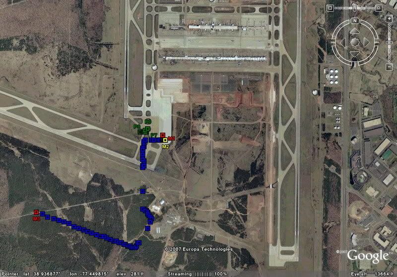
Here is a lat/long plot from the gate departing IAD runway 30, first flight of day. Obviously the INS was never updated/realigned at the gate.
Could a pilot expect the INS to realign itself in flight? If so, Could it be done within 10 mins of departure/climbout?
Maybe if i narrow this down with an example it will help...
Here is a lat/long plot from the gate departing IAD runway 30, first flight of day. Obviously the INS was never updated/realigned at the gate.
Could a pilot expect the INS to realign itself in flight? If so, Could it be done within 10 mins of departure/climbout?

Join Date: May 2000
Location: Seattle
Posts: 3,195
Likes: 0
Received 0 Likes
on
0 Posts
What airplane and navigation system are you talking about? Real airplane or some kind of flight simulator?
If the Present Position is incorrect when the INS is initialized, it will NOT "re-align" itself! It should be shut down and re-initialized with the correct Present Position.
Though the FMS or other navigation system MIGHT be capable of radio updating via GPS, DME, or other means, it will NOT "re-align" the INS! All it will do is put an appropriate correction into the position output. Depending on the navigation system, that correction may or may not persist after the updating is no longer available.
Guest
Posts: n/a
Greetings
No IRS realign in flight, alignement realign requires the platform to be stable. no acceleration, no movement, sometimes the movement created by loading container is enough to screw up the align process, on a modern Airliner.
Now looking at your plotting there is a shift (bias) between ploted and aircraft position, WGS84 coordinates aside, cross-check your initial position values, specificaly the last digits (sometimes gates coordinates are wrong
  ) verify with a hand held GPS.
That's all I can think of
No IRS realign in flight,
alignement realign requires the platform to be stable. no acceleration, no movement, sometimes the movement created by loading container is enough to screw up the align process, on a modern Airliner.Now looking at your plotting
there is a shift (bias) between ploted and aircraft position, WGS84 coordinates aside, cross-check your initial position values, specificaly the last digits (sometimes gates coordinates are wrong ) verify with a hand held GPS.That's all I can think of
Thread Starter
Join Date: Sep 2008
Location: USA
Posts: 33
Likes: 0
Received 0 Likes
on
0 Posts
The above are coordinates from an American Airlines B757 aircraft, manufactured 1991, no GPS.
From what i understand, it cannot be realigned in flight. And thats pretty much what i already thought....
Thanks again all...
From what i understand, it cannot be realigned in flight. And thats pretty much what i already thought....
Thanks again all...

Join Date: Apr 2005
Location: Stockholm Sweden
Age: 74
Posts: 569
Likes: 0
Received 0 Likes
on
0 Posts
15 years ago we used to have the coordinates of every gate in the FMS database. Not any more. Just one position for each airport. The pilot can choose to enter this position, or type in the actual coordinates of the gate. Now that IRS position is only a back up, and not the main nav position source it doesn't really matter. In your example I expect this is what happened. Even though the IRS is showing a position to the left of the runway, the FMS which will have been updated with DME (no GPS fitted) will show the actual aircraft position on its display, and on the EHSI.
By the way, I use the term IRS on purpose. B742 and L1011 era had INS fitted. FMS did not appear until the late 1970s. So the INS was the main navigation system. All modern aircraft are navigated by the FMS using inputs from various sources. You cannot navigate with a modern IRS (Inertial Reference System) unless you have a map to plot on. The FMS does the navigation, the IRS only tells it where it is.
By the way, I use the term IRS on purpose. B742 and L1011 era had INS fitted. FMS did not appear until the late 1970s. So the INS was the main navigation system. All modern aircraft are navigated by the FMS using inputs from various sources. You cannot navigate with a modern IRS (Inertial Reference System) unless you have a map to plot on. The FMS does the navigation, the IRS only tells it where it is.
Last edited by Swedish Steve; 25th Sep 2008 at 08:20.
Per Ardua ad Astraeus
Join Date: Mar 2000
Location: UK
Posts: 18,579
Likes: 0
Received 0 Likes
on
0 Posts
The FMS does the navigation, the IRS only tells it where it is.
 ).
).As soon as you add any output from an 'IRS' platform to give "where you are" it becomes an 'INS'.
Join Date: Sep 1998
Location: wherever
Age: 55
Posts: 1,616
Likes: 0
Received 0 Likes
on
0 Posts
I concur with BOAC to a certain degree.
IR(S) System
IR(U) Unit
I(NS) Navigation System
All different.
Think of the Unit as outputting accelleration values
System putting those values to some use.(perhaps using them to calculate a position relative to a given starting position)
Navigation System using a calculated postion to output stearing comands between given waypoints.
The Navigation function is usually done by FMS these days, hence the use of IRS rather than INS to describe the unit.
So the best description of an IRS is a navigation (position) sensor.
The IRU has to align itself in-order to accurately diferrentiate between aircraft accelerations and earth accelerations.
Some newer IRS can do this inflight. Honeywell do a nice micro IRS system with this capability so after a power interupt the unit will automatically re-align itself using GPS position to calculate aircraft track values and subtracting this from its total acceleration to calculate earth related accelerations then use these to re align to true north.
Way too complicated for my small brain but very very nice. Align In Motion will take between 15 and 30 minutes.
Join Date: May 2001
Location: Area 52
Posts: 180
Likes: 0
Received 0 Likes
on
0 Posts
If the correct runway was entered in the FMS and the pilots hit the TOGA switch when going into position the aircraft position should have been updated at that point. If not you could be be looking at "map shift" perhaps?
Join Date: Nov 2000
Location: Dre's mum's house
Posts: 1,432
Likes: 0
Received 0 Likes
on
0 Posts
The IRU isnt exactly a navigation sensor: it is more like an error reporting unit.
When you start in the morning, you tell it where it is. Either by telling it the gate position or by giving it the GPS position.
What it then tells you is where it isn't, as it measures accelerations away from that known position.
When you start in the morning, you tell it where it is. Either by telling it the gate position or by giving it the GPS position.
What it then tells you is where it isn't, as it measures accelerations away from that known position.

Join Date: Mar 2000
Location: Arizona USA
Posts: 8,571
Likes: 0
Received 0 Likes
on
0 Posts
By the way, I use the term IRS on purpose. B742 and L1011 era had INS fitted. FMS did not appear until the late 1970s.
These aircraft were fitted with three Litton ISS units (not capable of stand alone navigation), which in turn provided data to two Hamilton Sundstrand FMS units (far more useful than their Smiths cousins), and this whole kit and caboodle also included a 12 inch diagonal (CRT) moving map, all in one neat package.
The first and finest available, anywhere, circa 1976.
Aircraft type?
Lockheed TriStar.

Join Date: Mar 2007
Location: USofA
Posts: 1,235
Likes: 0
Received 0 Likes
on
0 Posts
On the B777 the FMC determines present position from these navigation systems; ADIRS, GPS and navigation radios. When receiving reliable GPS data, the primary mode of navigation is from a GPS updated FMC position. If GPS data is not available, cannot be validated, or is inhibited, the FMC position is updated using navigation radios. When navigation radios are available or no reliable, the FMC position comes from the ADIRU.
FMC position may be manually updated to any of the navigation system positions and this is accomplished on POS REF page 2.
FMC position may be manually updated to any of the navigation system positions and this is accomplished on POS REF page 2.
Join Date: Sep 1998
Location: wherever
Age: 55
Posts: 1,616
Likes: 0
Received 0 Likes
on
0 Posts
slim shady
The IRU isnt exactly a navigation sensor: it is more like an error reporting unit.
When you start in the morning, you tell it where it is. Either by telling it the gate position or by giving it the GPS position.
What it then tells you is where it isn't, as it measures accelerations away from that known position.
When you start in the morning, you tell it where it is. Either by telling it the gate position or by giving it the GPS position.
What it then tells you is where it isn't, as it measures accelerations away from that known position.
Position is only one output from an IRS.
When position output is not valid it may still output accelerations or track and groundspeed.
The FMS can use these outputs to navigate in dead reckoning mode. In this case it is sensing change in position so I guess it is a position sensor. Or at least thats how the manufacturers see it. I'm not going to argue with them.
Join Date: Apr 1999
Location: Canada
Age: 82
Posts: 91
Likes: 0
Received 0 Likes
on
0 Posts
I always liked this little explanation:
"Airline Inertial Guidance Systems The aircraft knows where it is at all times. It knows this because it knows where it isn't. By subtracting where it is from where it isn't, or where it isn't from where it is (whichever is the greater), it obtains a difference, or deviation.
The Inertial Guidance System uses deviations to generate error signal commands which instruct the aircraft to move from a position where it is to a position where it isn't, arriving at a position where it wasn't, or now is. Consequently, the position where it is, is now the position where it wasn't; thus, it follows logically that the position where it was is the position where it isn't.
In the event that the position where the aircraft now is, is not the position where it wasn't, the Inertial Guidance System has acquired a variation. Variations are caused by external factors, the discussions of which are beyond the scope of this report.
A variation is the difference between where the aircraft is and where the aircraft wasn't. If the variation is considered to be a factor of significant magnitude, a correction may be applied by the use of the autopilot system. However, use of this correction requires that the aircraft now knows where it was because the variation has modified some of the information which the aircraft has, so it is sure where it isn't.
Nevertheless, the aircraft is sure where it isn't (within reason) and it knows where it was. It now subtracts where it should be from where it isn't, where it ought to be from where it wasn't (or vice versa) and integrates the difference with the product of where it shouldn't be and where it was; thus obtaining the difference between its deviation and its variation, which is variable constant called "error".
Fascinating thread, you guys, with loads of good gen. Glad that the initial confusion between on-the-hoof INS/IRS position updating (impossible on any system I came across) and FMS position updating (happening all the time) was corrected by kijangmin and AMCS.
In the absence of today�s FMSs, with divers forms of position updating, it was important to align the INSs with the most accurate position possible. This is why, on non-FMS aeroplanes with early INS nav computers, we used to use the actual gate position. This was obtained from our Aerad/Jeppesen and/or the gate marker board at many airports. [In the latter case, beware of confusing seconds with decimals of minutes.] The more accurate the latitude, the less the INS drifted during the journey.
As kijangnim has pointed out:
An error in position input during initial alignment, apart from obvious bias, will give the wrong "G" initial value and induce wrong vertical acceleration (delta between the sensed real one and the erroneous one)
[Unquote]
And FE Hoppy:
The IRU has to align itself in-order to accurately diferrentiate between aircraft accelerations and earth accelerations.
[Unquote]
We could update the INS nav computer position en-route, but BelArgUSA�s method of doing it as you flew over a VOR was not an accurate one, because of the cone of confusion (for want of the correct term) over the station. Provided the VOR had a co-located DME, the best simple way was (and is) to take the DME distance as you fly due-south or due-north of the station (remembering to allow for the magnetic variation at the station). You know the longitude of the VOR, and simply apply the DME distance to the latitude. Try to do it when you are far enough away to minimise the DME slant-range error, but close enough to avoid a big error with the VOR bearing. I think about 30-90nm was considered a good compromise. [In the absence of DME, you can try a 45-degree or 26-degree �running fix�, assuming you know your track and GS; but you need some sort of chart for that, and you wouldn't use it for an update unless desperate.]
That earth-versus-aircraft acceleration business brings to mind the recent thread:
�A320 pitch-up at AP disconnect�
Sun worshipper
Join Date: Dec 2001
Location: Paris
Posts: 494
Likes: 0
Received 0 Likes
on
0 Posts
Provided the VOR had a co-located DME, the best simple way was (and is) to take the DME distance as you fly due-south or due-north of the station (remembering to allow for the magnetic variation at the station). You know the longitude of the VOR, and simply apply the DME distance to the latitude. Try to do it when you are far enough away to minimise the DME slant-range error, but close enough to avoid a big error with the VOR bearing. I think about 30-90nm was considered a good compromise.
The slant range error was minimised by entering both the DME coordinates and its MSL altitude. Some heavy manipulations, there...
As a matter of fact, on those old aircraft, one INS would provide navigational data to either the Captain (INS 1) or the First Officer (INS 2), INS 3 was used as an arbiter in case of vastly differing positions between 1 and 2.
Problem was that on autopilot/FD, the non-flying side would have a meaningless vertical bar after a while as the drifts were different.
Kept crews alert, though.
Hi Lemurian,
Everything you say is correct, but not relevant to what I was dealing with in the post you quote!
In the early days of INS on airliners - like retrofitted dual-INS on B707s, or triple INS on B747s and DC-10s - the associated nav computers (one per INS) were not capable of AUTOMATIC position updating of any kind. What you could do, however, was to update the PPOS in the nav computer MANUALLY, if you were sure it was necessary. That is the scenario I was addressing.
Re automatic updating of PPOS in FMSs, DME/DME remained the most accurate method en-route until the incorporation of GPS around 1990. I say "en-route" because updating at the start of the take-off, and LLZ/DME on approach (where available), were (and are) more accurate.
One day, for one reason or another, Uncle Sam may have to turn GPS off. And he probably won't want to issue a NOTAM until after he's done it...