


Aerial Survey?

Thread Starter
Aerial Survey?
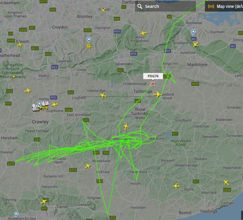
We have had an aerial survey aircraft flying over us for several days now covering the same area and carrying out multiple passes on each day.
https://www.flightradar24.com/data/a...-pdgx#22bf1418
It's back again today and I was wondering what they are surveying? It crossed my mind that it might be power lines rather than a photo survey, but why the multiple passes on multiple days?
It's back again today and I was wondering what they are surveying? It crossed my mind that it might be power lines rather than a photo survey, but why the multiple passes on multiple days?

Looking for oil/gas in 'them thar hills' ? There is fracking in East Sussex elsewhere. Either that or the authorities are on to a hot tip about those drones that were plaguing LGW last Xmas.
Join Date: May 2011
Location: Hampshire
Age: 76
Posts: 821
Likes: 0
Received 0 Likes
on
0 Posts
Actually, there is no fracking in Sussex. What is going on there is bog standard test drilling but once the anti-frackers decided that meant fracking, there was no stopping the rumours.
Thread Starter
Oil and Gas in my back yard!
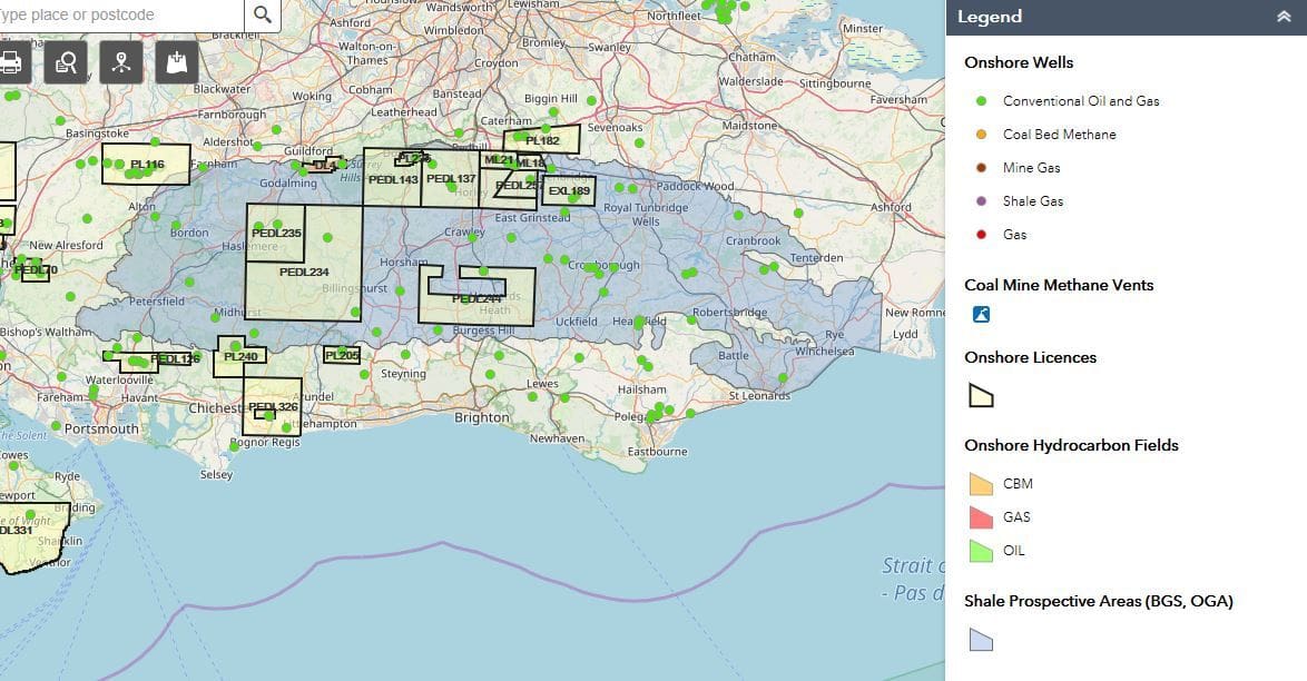
They have been drilling for oil around here since at least the 1950's. I found that out earlier this year when I did a bit of research on the subject. The bore hole closest to me produced gas & oil (without fracking), but not (at that time) in commercial quantities. It was however significantly, the first to produce Jurassic oil onshore in this country.
More info here.... https://ogauthority.maps.arcgis.com/...545d222e57ddaa
And here ���. https://ukogl.org.uk/
So they know for certain what's down there and how much it will produce. I'm am unable to determine from Google what they will get from undertaking aerial surveys, perhaps someone in the know, could enlighten me.
Airborne survey work for minerals etc depends on the sensor - you can't detect subsurface oil or gas directly from an aeroplane (although some smart guys conned a major French Oil Company back in the 70's to think they could...)
generally a straight Magnetometer (as per any decent marine ASW aircraft) is used to map faults etc. You can use a highly sensitive gravimeter as well - this is used to calculate the thickness of the rocks above "basement"
These are useful techniques in unknown areas - onshore UK there is a load of freely available data covering the whole country so running an expensive aerial survey is most unlikely
The guys who own the acreage in the area use seismic to locate their wells - the main current operator (and the only one doing anything) - is UKOG - who are testing the "Gatwick Gusher" right now about 4 km N of LGW - check their website
The flight path shown is outside the area currently Licensed for exploration. Could be someone trying something new but more likely a photo survey for pipelines, powerlines or developers.
Asturias mentioned airborne gravity which has only become technically viable in the last 15-20 years with the advent of sophisticated airborne equipment and critically, highly precise GPS readings.
I was involved with an airborne survey in Chad over ten years ago. The accuracy of the survey was astounding. We had reliable gravity readings of 1 milligal, which is about one-millionth of a "g". These data were extracted from raw data that included "noise" of plus or minus 1 to 2 "g".
However, even with that accuracy, you can't use the data to choose prospective structures. We were using it to identify the edges of a Cretaceous rift basin that was buried beneath 500 m of flat-lying Tertiary sediments, after which we were able to properly position our seismic survey over the rift basin. A $500,000 survey saved us millions.
As Asturias said, this survey over Kent and Sussex will almost certainly be for some mundane purpose, like updating maps. Anti-frackers can relax!
WB627, based on a whole career of looking for oil and gas and occasionally finding some, I would like to modify your statement. 
I was involved with an airborne survey in Chad over ten years ago. The accuracy of the survey was astounding. We had reliable gravity readings of 1 milligal, which is about one-millionth of a "g". These data were extracted from raw data that included "noise" of plus or minus 1 to 2 "g".
However, even with that accuracy, you can't use the data to choose prospective structures. We were using it to identify the edges of a Cretaceous rift basin that was buried beneath 500 m of flat-lying Tertiary sediments, after which we were able to properly position our seismic survey over the rift basin. A $500,000 survey saved us millions.
As Asturias said, this survey over Kent and Sussex will almost certainly be for some mundane purpose, like updating maps. Anti-frackers can relax!
So they know for certain what's down there and how much it will produce.
So they think they know what's down there and they have guessed at how much it will produce.
Last edited by India Four Two; 13th Nov 2019 at 02:37.
It's worth noting that in the N Sea - even after 60 years of exploration and 4000 oil wells and God knows how much has been spent on exploration that the success rate for a new exploration well is still only 35-45%.
Of course the size of the targets has gone way down - 20 years ago people were chasing 100 million barrels - now 10 million is good result in UK waters.
Of course the size of the targets has gone way down - 20 years ago people were chasing 100 million barrels - now 10 million is good result in UK waters.
I was involved with an airborne survey in Chad over ten years ago. The accuracy of the survey was astounding. We had reliable gravity readings of 1 milligal, which is about one-millionth of a "g". These data were extracted from raw data that included "noise" of plus or minus 1 to 2 "g".
 .
.You are saying you were flying a piece of kit around in a presumably vibrating aircraft, presumably in turbulence, and nevertheless it was still measuring "g" to an accuracy of one in a million ...If that was the case colour me very very impressed..in simple terms how the heck did it do that? ( simple explanation or a suitable link to one will do)
Join Date: Dec 2015
Location: s e england
Posts: 103
Likes: 0
Received 0 Likes
on
0 Posts
Re first oil and gas in Sussex; n the early 1900's they were drilling for water for the locomotives at the railway station at Heathfield in East Sussex, but struck gas instead. Was used to light the streets of Heathfield and was exported to London by train for experimental purposes, as the gas was particularly clean.
Thread Starter
Thank you all for your replies.I had read about the gas lights in Heathfield, probably in one of those local advertising magazines that drops through the door periodically, but I did not connect them to the wells bored in Heathfield that I saw on the map when I was doing a bit of research earlier this year. Most of the wells in Heathfield were bored between 1895 and 1902 with BP returning in 1955 for another go. The gas must have come as a bit of a surprise to them as they were looking for water! There were a lot of wells drilled around here by BP in the mid 1950’s, the two near me were two of them. Having been in construction for over 40 years I was used to reading bore hole logs, but not down to 5400ft as these two were! Conoco seem to have bored some more in the mid 80’s.India Four Two you are absolutely right to correct my statement with “So they think they know what's down there and they have guessed at how much it will produce”. There is no indication in the reports as to the potential quantity of gas or oil down there, just that it is there. The two near me, Ashdown 1 near the Army camp and Ashdown 2 on the golf course produced up to 20,000 cu ft of gas per day and 150 gallons of oil per day during the course of drilling, but there is no indication as to how long it would have lasted.
Drain Bamaged
Just excuse me for asking if I've understood that comment- I'm sometimes hard of reading....
You are saying you were flying a piece of kit around in a presumably vibrating aircraft, presumably in turbulence, and nevertheless it was still measuring "g" to an accuracy of one in a million ...If that was the case colour me very very impressed..in simple terms how the heck did it do that? ( simple explanation or a suitable link to one will do)
.You are saying you were flying a piece of kit around in a presumably vibrating aircraft, presumably in turbulence, and nevertheless it was still measuring "g" to an accuracy of one in a million ...If that was the case colour me very very impressed..in simple terms how the heck did it do that? ( simple explanation or a suitable link to one will do)
This kind of instruments where initially used as navigation systems in nuclear submarines back in the 80's since they are passif.
Then someone at Lockheed Martin had the idea of throwing it inside an aircraft.
Actually they had it in a van and they strapped the van inside a C-130....
"in simple terms how the heck did it do that?"
as you've probably worked out "simple" and airborne gravity" can't be used in the same article................ They normally measure the gradient and it's variation
https://en.wikipedia.org/wiki/Gravity_gradiometry is a reasonable start.
As for Oil & gas in the Weald there are several producing fields - mainly to the south side of the basin but the current operation at Horse Hill is very close to Gatwick and that has just received planning approval for 2-3000 barrels a day for 20 years.
... colour me very very impressed.
Have a look at the impressively colourful maps in the following links.
Thanks Asturias56 for posting the Airborne Gravity link. Interestingly, the survey that I was involved with, used what as far as I know, is the only commercially successful airborne gravity meter, rather than a gradiometer.
The first link is a good summary from the survey company’s web page. The second link is a technical article with enough technical detail to make your head spin, but it points out how post-survey processing is the key to good results.
An important factor in obtaining good results is having a good QC consultant, whose job is to keep the contractor to the survey specs and to require reflying of any lines that don’t meet the specs. We had a very good one - he flew with the crew in the Caravan on every survey line.
Even though they started at first light, to minimize turbulence, flying for several hours at low level over African savannah is an exhausting business.
SGL - Airborne Gravity with AIRGrav
https://csegrecorder.com/articles/vi...gravity-system
As an aside, my house lies within the area of the Turner Valley survey described in the links!
30 km a day production for hi-res helicopter work. Ouch!! You could do it a lot cheaper on foot but then a lot of these places can't be reached or surveyed on foot.


