


Airbus Within 6ft of the Ground nearly 1 mile Short of Runway

Join Date: Jun 2000
Location: UK
Posts: 71
Likes: 0
Received 0 Likes
on
0 Posts
UK. AA Safety Notice SN 2019-001 CFIT RISK VNAV & 2D etc
This risk was identified by the UK CAA in 2018.
see UK CAA SAFETY NOTICE SN/2019-001. Risk of Controlled Flight into Terrain during 3D BARO-VNAV and 2D Approaches
(Altimeter Setting Procedures)
This latent Risk remains and must be mitigated on every approach using TEM. The lack of a PULL-UP Warning makes the issue acute.
Link to CAA Safety Notice: SN-2019/001: Risk of Controlled Flight into Terrain During 3D BARO-VNAV and 2D Approaches (Altimeter Settings)
Last edited by SAM 2M; 14th Jul 2022 at 20:17.

Well, as we have said, there have been SOPs in place for years to cross check the QNH : PM listens to the ATIS at a suitable point and writes it down on a "bug card", which is placed on the centre console where both pilots can see it. And CM1 sets the ATIS QNH on their altimeter and resets their altimeter to standard, or sets it on the standby altimeter. Then, when ATC gives descent to an altitude, they will state the QNH and the crew will check that it is close to what is written on the bug card and agrees with what has been set on CM1's or the standby altimeter.
I agree with Alex, a good revision point for all of us.
Altitude vs distance checks are meaningless if the QNH is incorrect. Height, (from the RAD Alt) vs distance checks would be a proper, meaningful check, and NPA plates should be published with this information.
I am not sure that throwing more technology at this problem, e.g. automatic setting of QNH via radio link or whatever, would be worth bothering with : it would bring more problems than it might solve. We already know how to do this: make an independent cross-check of the QNH - especially if there is no ground transmitted glide-slope information available.
Join Date: Mar 2017
Location: everywhere
Posts: 444
Likes: 0
Received 0 Likes
on
0 Posts
Well, as we have said, there have been SOPs in place for years to cross check the QNH : PM listens to the ATIS at a suitable point and writes it down on a "bug card", which is placed on the centre console where both pilots can see it. And CM1 sets the ATIS QNH on their altimeter and resets their altimeter to standard, or sets it on the standby altimeter. Then, when ATC gives descent to an altitude, they will state the QNH and the crew will check that it is close to what is written on the bug card and agrees with what has been set on CM1's or the standby altimeter.
I agree with Alex, a good revision point for all of us.
Altitude vs distance checks are meaningless if the QNH is incorrect. Height, (from the RAD Alt) vs distance checks would be a proper, meaningful check, and NPA plates should be published with this information.
I am not sure that throwing more technology at this problem, e.g. automatic setting of QNH via radio link or whatever, would be worth bothering with : it would bring more problems than it might solve. We already know how to do this: make an independent cross-check of the QNH - especially if there is no ground transmitted glide-slope information available.
I agree with Alex, a good revision point for all of us.
Altitude vs distance checks are meaningless if the QNH is incorrect. Height, (from the RAD Alt) vs distance checks would be a proper, meaningful check, and NPA plates should be published with this information.
I am not sure that throwing more technology at this problem, e.g. automatic setting of QNH via radio link or whatever, would be worth bothering with : it would bring more problems than it might solve. We already know how to do this: make an independent cross-check of the QNH - especially if there is no ground transmitted glide-slope information available.
Join Date: Oct 2007
Location: Scotland
Posts: 132
Likes: 0
Received 0 Likes
on
0 Posts
It doesn't capture the error here as mentioned above.
Think if the platform altitude for the FAF was 3000' AGL at 10 miles. With a barometer set 10hPa high, your altimeter will show 3000' but you'd actually be at an altitude of 2700'. This error is maintained the whole way down the approach path - you are reading what appear to be correct altitude readings v the distance, but you are actually 300' lower at each mile. This culminates in you being at 0' at 1nm from the threshold, with your altimeter reading 300'.
Think if the platform altitude for the FAF was 3000' AGL at 10 miles. With a barometer set 10hPa high, your altimeter will show 3000' but you'd actually be at an altitude of 2700'. This error is maintained the whole way down the approach path - you are reading what appear to be correct altitude readings v the distance, but you are actually 300' lower at each mile. This culminates in you being at 0' at 1nm from the threshold, with your altimeter reading 300'.
With the weather as advertised, a properly executed monitored approach would have had at least one crew member looking out of the window and realizing they were in the wrong place.
Last edited by Oldaircrew; 15th Jul 2022 at 08:00. Reason: Commentary added
Altitude - Distance
Isn't the point that whilst altitude is checked first, the distance has to be from the runway / threshold.
The intent is to achieve some independence from the FMS, ideally from DME, or if not, apply the small, simpler distance correction between the DH position and threshold.
Simple rules of thumb required - general awareness - I recall �never less than 150 ft RA until DH�.
EGPWS should have detected this event; T2CAS, not known, but very surprising if it isn't capable.
@A320LGW;
Yes exactly; that's why I am suggesting it. With a NPA approach, you are heavily reliant on having set the correct QNH, and have no means of cross checking that you are on the correct profile - as you do with a ground transmitted glide-slope. Bear in mind it may be IMC, with absolutely no external visual references and a bad radio link in a noisy cockpit, with language issues. A surveyed series of Rad Alt heights, for, say, the last 4 miles* written on the NPA plate might be an easy way of providing that cross check, and allowing a safe go-around if something did not match up. Checking altitudes against distance to go on a NPA is useless if the QNH is set wrong, as this near CFIT has shown.
Even if a crew does monitor the Rad Alt, the terrain might not be flat, as you say, so the readings might be quite different from the altitudes - even if using QFE, so not always easy to decide if the Rad Alt figure is reasonable or not. Having a series of surveyed heights vs distances on the plate, might give improved reassurance?
*Or perhaps just one radio altimeter check height printed on the plate for the 4 nm point would serve as a gross error check?
The plates we use at least don't include any height v distance table
Yes exactly; that's why I am suggesting it. With a NPA approach, you are heavily reliant on having set the correct QNH, and have no means of cross checking that you are on the correct profile - as you do with a ground transmitted glide-slope. Bear in mind it may be IMC, with absolutely no external visual references and a bad radio link in a noisy cockpit, with language issues. A surveyed series of Rad Alt heights, for, say, the last 4 miles* written on the NPA plate might be an easy way of providing that cross check, and allowing a safe go-around if something did not match up. Checking altitudes against distance to go on a NPA is useless if the QNH is set wrong, as this near CFIT has shown.
Even if a crew does monitor the Rad Alt, the terrain might not be flat, as you say, so the readings might be quite different from the altitudes - even if using QFE, so not always easy to decide if the Rad Alt figure is reasonable or not. Having a series of surveyed heights vs distances on the plate, might give improved reassurance?
*Or perhaps just one radio altimeter check height printed on the plate for the 4 nm point would serve as a gross error check?
@A320LGW;
Yes exactly; that's why I am suggesting it. With a NPA approach, you are heavily reliant on having set the correct QNH, and have no means of cross checking that you are on the correct profile - as you do with a ground transmitted glide-slope. Bear in mind it may be IMC, with absolutely no external visual references and a bad radio link in a noisy cockpit, with language issues. A surveyed series of Rad Alt heights, for, say, the last 4 miles* written on the NPA plate might be an easy way of providing that cross check, and allowing a safe go-around if something did not match up. Checking altitudes against distance to go on a NPA is useless if the QNH is set wrong, as this near CFIT has shown.
Even if a crew does monitor the Rad Alt, the terrain might not be flat, as you say, so the readings might be quite different from the altitudes - even if using QFE, so not always easy to decide if the Rad Alt figure is reasonable or not. Having a series of surveyed heights vs distances on the plate, might give improved reassurance?
*Or perhaps just one radio altimeter check height printed on the plate for the 4 nm point would serve as a gross error check?
When we get into increased stress situations, the ability for the average human to cope and even comprehend external stimuli drops off, as a function of stress and cognitive load. We then start to drop signals that would normally be received as we tend to focus on the highest priority task. Whether we even can multitask as such (except for our better halves, that can certainly do that....) is a question that has raised some debate, do we multi task or do we rapidly serialise demands. I suspect it is a bit of both normally, but under stress we prioritise on highest perceived risk items and "loadshed". In this case, it is possible that the crew really didn't get the EGPWS expanded height callouts, but that would include the IQ challenge of "Retard, Retard" which is a simple RALT function... Its a while since I looked at A320/330 DFDR readouts, I don't believe that the alt call discretes are recorded though.
Join Date: Oct 2007
Location: Scotland
Posts: 132
Likes: 0
Received 0 Likes
on
0 Posts
Checking altitudes against distance to go on a NPA is useless if the QNH is set wrong, as this near CFIT has shown.
No it’s not if you’re using an independent source as ALF507 says.
No it’s not if you’re using an independent source as ALF507 says.
Only half a speed-brake
Only half a speed-brake
Not on his line of thinking, but it is an excellent idea.
Why not have every NPA publish the radio height at 1000 height point (or equivalent). Alive serious.
The final report will not be nice reading. The RA autocall 50, 30, 20 or de-configured (why!) and the RETARD call too at 10.
BTW I recall a training session going very wrong and causing a similar situation. Under workload the orange RA lettering did not deliver the message. The 100 RA preceding 100 above surely did.
The event is exactly verbatim what the CAA.UK document linked above warns about. Also with the explanation why EGPWS could not pick it up.
Oldaircrew commented regarding the use of "monitored approach", which many regular readers will know I totally support. While I’m always reluctant to assume too much before a full report is issued, the preliminary report seems to be clear that in this event the crew flew straight through (what they believed to be) the MDA at a constant descent rate of 12 ft/sec, without any visual references. It appears that the need for a go-around was not manifested for a further 6 seconds (72 ft further descent), when the Captain disconnected the autopilot and made a nose-up input, but a full go-around was not initiated for a further 3 seconds when TOGA was applied. So even if the altimeters had been set correctly obstacle clearance would have been infringed – at the lowest point the aircraft was 123 feet below the MDA in full IMC. From the Captain’s actions (autopilot disconnect and stick back and then TOGA power 3 seconds later) it seems likely that he was not mentally prepared for a go-around.
So regardless of the altimetry issue, we have a prima facie serious breach of AOM in that the aircraft descended below the MDA without the Captain having seen visual cues which had [already] “been in view for sufficient time for the pilot to have made an assessment of the aircraft position and rate of change of position in relation to the desired flight path.” (ICAO definition of reqjired visual refernce).
If a monitored approach procedure had been in use it is LIKELY that the go-around would have occurred much earlier, with the F/O flying the go-around for which he/she had been fully prepared, while the Captain would have been seeking visual references prior reaching MDA and responding to a “Decide” call AT MDA. Speculatively only, it’s also possible that as the pilot operating the radio would have been the Captain, the initial incorrect QNH from ATC would have have been more readily queried.
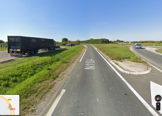
There’s also a (probably irrelevant) discrepancy in that the preliminary report text says the lowest point reached was 0.8nm from the threshold. This places it very close to the Route Nationale N1104, while the Google map trace provided puts it a further 0.2 nm away on the far side of a field. Depending on which is correct, there’s clearly the possibility of the aircraft hitting vehicles at an RA of 6ft.

So regardless of the altimetry issue, we have a prima facie serious breach of AOM in that the aircraft descended below the MDA without the Captain having seen visual cues which had [already] “been in view for sufficient time for the pilot to have made an assessment of the aircraft position and rate of change of position in relation to the desired flight path.” (ICAO definition of reqjired visual refernce).
If a monitored approach procedure had been in use it is LIKELY that the go-around would have occurred much earlier, with the F/O flying the go-around for which he/she had been fully prepared, while the Captain would have been seeking visual references prior reaching MDA and responding to a “Decide” call AT MDA. Speculatively only, it’s also possible that as the pilot operating the radio would have been the Captain, the initial incorrect QNH from ATC would have have been more readily queried.
There’s also a (probably irrelevant) discrepancy in that the preliminary report text says the lowest point reached was 0.8nm from the threshold. This places it very close to the Route Nationale N1104, while the Google map trace provided puts it a further 0.2 nm away on the far side of a field. Depending on which is correct, there’s clearly the possibility of the aircraft hitting vehicles at an RA of 6ft.
I've still not seen why they were given the runway with the ILS out of service in these poor conditions. It's bizarre that the country who strove to be the world's first with full Autoland (which the French were, at Paris and Lyon, in the 1960s) lapses down to this.
Last edited by WHBM; 15th Jul 2022 at 20:35.
Join Date: Mar 2010
Location: Often in Jersey, but mainly in the past.
Age: 79
Posts: 7,807
Received 135 Likes
on
63 Posts
Possibly a red herring [ou hareng rouge] but I wondered whether the controller was mentally saturated by certain numbers ...
4311 Callsign
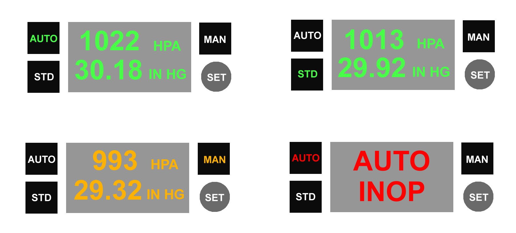
1001 QNH
1011 Wrong QNH
4311 Callsign
1001 QNH
1011 Wrong QNH
Thread Starter
Join Date: Dec 2020
Location: Manchester
Posts: 52
Likes: 0
Received 0 Likes
on
0 Posts
And as the correct QNH was given in French, and read back in French, two further opportunities for the crew, to pick up on the error. I will remind those who claim two languages are not an issue when the next collision occurs. tick tock tick tock.
�Possibly red herring ��, best grilled slowly.
Even if the view is irrelevant in this incident, it is an important contribution to wider thinking and alternative understandings required in modern aviation.

Even if the view is irrelevant in this incident, it is an important contribution to wider thinking and alternative understandings required in modern aviation.
ALF507 and Oldaircrew; My point earlier was that the altitude was the thing that was seriously wrong here, not the distance.
With the QNH being grievously wrong; quite why this crew did not notice their low Rad Alt, readings; quite why it did not call out, (maybe pin-programmed off), quite why PF disconnected the auto-pilot in an A320 family to perform a go-around are pertinent questions. Were they completely conversant with RNAV approaches in A320 family?
At 11:32:24 the PM did appear to hesitate when reading back the QNH early on - so there may have been doubt there, but they presumably convinced themselves that they were wrong and assumed ATC were correct.
Can anyone throw more light on EGPWS - should it have called out?
From old copy of Airbus FCOM:
- The [EGPWS] reference altitude is computed based on the current aircraft altitude or, if descending more than 1 000 ft/min, the altitude expected in 30 s
Uplinker,
The error appears to be incorrect QNH, which results in erroneous indicated altitude - what the pilots see.
An altitude - range table, based on threshold distance, relates the altitude which should be seen at a specific distance, thus a check of the displayed altitude at x nm would identify an indicated value which was below the required chart altitude - below flight path.
The critical points here are (1) having a chart and (2) an appropriate reference position for distance - ideally the threshold. So with an adequate distance reference, the low altitude / below flight path could be identified (but not necessarily the wrong QNH).
The above does not relate to the report of this incident; see # 149
Rad Alt points noted (value of call outs … ‘Retard’ !!!!), but this assumes that crews regularly check RA indication and that it can be related to the approach; hence my previous rule of thumb - nothing complicated. Also, hearing perception - voice input is the first sense to degrade with increasing workload.
I recall that there should be a min RA in the design of every type of approach, e.g. not less than xxx at FAF; memory fails me, so my >150 ft until visual, if I look at the RA
But what did the crew look at, see?
A lesson to be shared is how the crew identified the need to GA, awareness, understanding, and how this was actioned.
EGPWS VIII Pilots Guide Rev F, dated May 2009 - check for later versions.
“The Terrain Clearance Floor (TCF) function (enabled with TAD) enhances the basic GPWS Modes by alerting the pilot of descent below a defined “Terrain Clearance Floor” regardless of the aircraft configuration. The TCF alert is a function of the aircraft’s Radio Altitude and distance (calculated from latitude/longitude position) relative to the center of the nearest runway in the database (all runways greater than 3500 feet in length).”
Improvements by modification standard:-
“In -210-210 and later versions, the TCF alert envelope and Envelope Bias Factor are improved. … . The Envelope Bias Factor is reduced (moved closer to the runway) when higher accuracy aircraft position and runway position information is available.
This is typically 1/3 to 1 nm providing greater protection against landing short events.
With version -218-218 and later models, the envelope bias factor is reduced to 1/4 nm if runway and position data is of high integrity.
Also in -210-210 and later versions, runway selection logic is improved to better identify the destination runway. Comprehensive aircraft position and navigation information is used to evaluate proximate runways and determine the most likely destination runway for all alerting purposes.”
“In -210-210 and later versions, a Runway Field Clearance Floor feature is included. This is similar to the TCF feature except that RFCF is based on the current aircraft position and height above the destination runway, using Geometric Altitude (in lieu of Radio Altitude).”
A critical aspect of the above is the nav accuracy, and GPS geometric altitude, which should have been sufficient given the type of approach being flown. But not overlooking modification standard and database updates.
I strongly suspect that this aircraft was fitted with T2CAS, an Airbus standard at some point.
I have only evaluated that system in early development thus cannot relate to current performance, but surprising if not equivalent to EGPWS.
Another factor is the generic use of ‘TAWS’, which might mask differences in systems’ capability - regulatory issue (level playing field, ambiguity, etc - the crew will manage, will m…)
.
The error appears to be incorrect QNH, which results in erroneous indicated altitude - what the pilots see.
The critical points here are (1) having a chart and (2) an appropriate reference position for distance - ideally the threshold. So with an adequate distance reference, the low altitude / below flight path could be identified (but not necessarily the wrong QNH).
The above does not relate to the report of this incident; see # 149
Rad Alt points noted (value of call outs … ‘Retard’ !!!!), but this assumes that crews regularly check RA indication and that it can be related to the approach; hence my previous rule of thumb - nothing complicated. Also, hearing perception - voice input is the first sense to degrade with increasing workload.
I recall that there should be a min RA in the design of every type of approach, e.g. not less than xxx at FAF; memory fails me, so my >150 ft until visual, if I look at the RA
But what did the crew look at, see?
A lesson to be shared is how the crew identified the need to GA, awareness, understanding, and how this was actioned.
EGPWS VIII Pilots Guide Rev F, dated May 2009 - check for later versions.
“The Terrain Clearance Floor (TCF) function (enabled with TAD) enhances the basic GPWS Modes by alerting the pilot of descent below a defined “Terrain Clearance Floor” regardless of the aircraft configuration. The TCF alert is a function of the aircraft’s Radio Altitude and distance (calculated from latitude/longitude position) relative to the center of the nearest runway in the database (all runways greater than 3500 feet in length).”
Improvements by modification standard:-
“In -210-210 and later versions, the TCF alert envelope and Envelope Bias Factor are improved. … . The Envelope Bias Factor is reduced (moved closer to the runway) when higher accuracy aircraft position and runway position information is available.
This is typically 1/3 to 1 nm providing greater protection against landing short events.
With version -218-218 and later models, the envelope bias factor is reduced to 1/4 nm if runway and position data is of high integrity.
Also in -210-210 and later versions, runway selection logic is improved to better identify the destination runway. Comprehensive aircraft position and navigation information is used to evaluate proximate runways and determine the most likely destination runway for all alerting purposes.”
“In -210-210 and later versions, a Runway Field Clearance Floor feature is included. This is similar to the TCF feature except that RFCF is based on the current aircraft position and height above the destination runway, using Geometric Altitude (in lieu of Radio Altitude).”
A critical aspect of the above is the nav accuracy, and GPS geometric altitude, which should have been sufficient given the type of approach being flown. But not overlooking modification standard and database updates.
I strongly suspect that this aircraft was fitted with T2CAS, an Airbus standard at some point.
I have only evaluated that system in early development thus cannot relate to current performance, but surprising if not equivalent to EGPWS.
Another factor is the generic use of ‘TAWS’, which might mask differences in systems’ capability - regulatory issue (level playing field, ambiguity, etc - the crew will manage, will m…)
.
Last edited by alf5071h; 16th Jul 2022 at 21:37. Reason: P S removed