


4th Aug 2018 Junkers JU52 crashed in Switzerland

Join Date: Apr 2017
Location: England
Posts: 75
Likes: 0
Received 0 Likes
on
0 Posts
Thanks, DRDR.
A question. The flight is not there at 16.50, but presumably must be fairly close, within ten miles or so, if it's down by 17.00. I've strained my eyes on the panoramic view for 16.50, but I can't pick it out anywhere. Which way would it likely approach?
A question. The flight is not there at 16.50, but presumably must be fairly close, within ten miles or so, if it's down by 17.00. I've strained my eyes on the panoramic view for 16.50, but I can't pick it out anywhere. Which way would it likely approach?

Join Date: Jan 2008
Location: UK
Posts: 1,515
Likes: 0
Received 0 Likes
on
0 Posts
Now we have to understand why they apparently completely lost control. I remain perplexed.
I would have thought anyone with even a rudimentary knowledge of aviation could easily come up with several obvious scenarios as to how the aircraft came to the fate it did - given the circumstances we already know. Some choose to speculate, on here and elsewhere, some choose not to. I choose not to, but I would observe that some of the comments on here regarding age/experience etc, show a degree of a lack of awareness of how dynamic and variable human factors are.
Maybe that contributes to your puzzlement, maybe it does not. Either way - no offence meant, and my condolences to everybody affected by this horrible tragedy.
Since the Ju52 is a slow bird, it takes more than a simple stall to wind down in an arrow like descending crash. Normally you and especial the two experienced pilots would have recovered the bird within 500 to 1000 feet even from a power-on or power-off stall. And it did not crash in a flat spin. There is reason to believe that they had those altitude margin. So there is more to the story which hopefully will come to light in due time.
This indeed, more eloquently than I would have been able, summarize while I'm perplexed.
I don't see any obvious scenario where they would end up in an almost vertical dive from apparent controlled flight, with no structural damage, relatively tame weather and a very experienced crew. Sure there are some less likely situations that could think of but this remains somewhat baffling. Time will hopefully tell.
Join Date: Apr 2007
Location: EU
Posts: 28
Likes: 0
Received 0 Likes
on
0 Posts
Thanks, DRDR.
A question. The flight is not there at 16.50, but presumably must be fairly close, within ten miles or so, if it's down by 17.00. I've strained my eyes on the panoramic view for 16.50, but I can't pick it out anywhere. Which way would it likely approach?
A question. The flight is not there at 16.50, but presumably must be fairly close, within ten miles or so, if it's down by 17.00. I've strained my eyes on the panoramic view for 16.50, but I can't pick it out anywhere. Which way would it likely approach?
By the way: The operator of the camera came back to me: They have already been approached by the authorities, but unfortunately they do not have any further images.

Join Date: Dec 2013
Location: Norfolk
Age: 67
Posts: 1
Likes: 0
Received 0 Likes
on
0 Posts
The aircraft was seen apparently flying normally yet a few minutes later impacted the ground vertically and partially inverted with wings and control surfaces apparently intact.
The aircraft was flying at modest airspeed speed, compared to more modern aircraft, in a mountainous area which was subject to winds measuring a significant percentage of the airspeed.
A sharp stall combined with an abrupt forward shift in the center of gravity of the aircraft accounts for the observed results. The exact details will be established by investigators, but this was an aircraft that was nearly 80 years old. It may have been in perfect condition but it was built to standards that were still being explored with single wings a novelty as an alternative to biplane wings!
A huge loss to aviation history and a great tragedy for all involved.
Join Date: Aug 2018
Location: With hardship in an old Astra
Posts: 45
Likes: 0
Received 0 Likes
on
0 Posts
I have no idea. Like you I cannot find the aircraft anywhere in the 360� (horizontal!) image taken at 16:50. So it must have been out of the rather wide view of the 22 megapixel panoramic camera system for up to 5 minutes or it must have been just above it.
By the way: The operator of the camera came back to me: They have already been approached by the authorities, but unfortunately they do not have any further images.
By the way: The operator of the camera came back to me: They have already been approached by the authorities, but unfortunately they do not have any further images.
There is a possible aircraft approaching in the Mutta Rodunda 1650hrs panorama.
As a newcomer, I don�t think my previous attempt to upload annotated image clips succeeded, so here is a
Roughly SW of the camera (if the direction icon at the top right of the screen is to be believed), is a wooden post, range approx. 10m. Beyond this is a green ridge-line range approx. 4km. Go slightly left from the post along the top of the ridge-line, and there is a lone cable-car pylon. Go further left again (about the same angle), and there is a white cable-car station building. Go back half-way between the station building and the pylon, and look higher up on the image� just below the most distant (much darker) ridge-line. There appears to be an aeroplane approaching at around the same elevation as the camera (� a few 1000ft). It�s too distant to make out much (even using 500% image magnification), other than it appears to be in level flight.
Would you be able to upload a clip from this image for me, please?
Join Date: Apr 2007
Location: EU
Posts: 28
Likes: 0
Received 0 Likes
on
0 Posts
flying object #1:
x = 9138 y = 926
flying object #2:
x = 10049 y = 936
The left most object might fit to the estimated flightpath.
The cockpit is a separate compartment, but there is no door between pax and crew. Pax are invited one after the other to the cockpit (standing behind pilots) and get things explained.
Guest
Join Date: Nov 1999
Location: In the shadow of R101
Posts: 259
Likes: 0
Received 0 Likes
on
0 Posts
Join Date: Jun 2009
Location: Switzerland
Age: 39
Posts: 56
Likes: 0
Received 0 Likes
on
0 Posts
Thanks, DRDR.
A question. The flight is not there at 16.50, but presumably must be fairly close, within ten miles or so, if it's down by 17.00. I've strained my eyes on the panoramic view for 16.50, but I can't pick it out anywhere. Which way would it likely approach?
A question. The flight is not there at 16.50, but presumably must be fairly close, within ten miles or so, if it's down by 17.00. I've strained my eyes on the panoramic view for 16.50, but I can't pick it out anywhere. Which way would it likely approach?
From my calculations the impact happened at 16.57 LT (14.57 UTC), also comparing the webcame images from 16.50 and 17.00. I also look for the JU in the panoramic images but I think it was more or less abeam Illanz at 16.50 so too far away.
Join Date: Jul 2017
Location: Washington, D.C.
Posts: 3
Likes: 0
Received 0 Likes
on
0 Posts
There's a photo of the interior of a Ju-52 in the Blick article--it's no. 20 of the 32 photos in the slideshow at the bottom of the story. If that's the accident aircraft or one just like it, there's open access but through a cutout, and a normal-sized adult (certainly men) would have to hunker down to get through.
Join Date: Apr 2017
Location: England
Posts: 75
Likes: 0
Received 0 Likes
on
0 Posts
DRDR,
There is a possible aircraft approaching in the Mutta Rodunda 1650hrs panorama.
As a newcomer, I don�t think my previous attempt to upload annotated image clips succeeded, so here is averbose verbal target indication:
Roughly SW of the camera (if the direction icon at the top right of the screen is to be believed), is a wooden post, range approx. 10m. Beyond this is a green ridge-line range approx. 4km. Go slightly left from the post along the top of the ridge-line, and there is a lone cable-car pylon. Go further left again (about the same angle), and there is a white cable-car station building. Go back half-way between the station building and the pylon, and look higher up on the image� just below the most distant (much darker) ridge-line. There appears to be an aeroplane approaching at around the same elevation as the camera (� a few 1000ft). It�s too distant to make out much (even using 500% image magnification), other than it appears to be in level flight.
Would you be able to upload a clip from this image for me, please?
There is a possible aircraft approaching in the Mutta Rodunda 1650hrs panorama.
As a newcomer, I don�t think my previous attempt to upload annotated image clips succeeded, so here is a
Roughly SW of the camera (if the direction icon at the top right of the screen is to be believed), is a wooden post, range approx. 10m. Beyond this is a green ridge-line range approx. 4km. Go slightly left from the post along the top of the ridge-line, and there is a lone cable-car pylon. Go further left again (about the same angle), and there is a white cable-car station building. Go back half-way between the station building and the pylon, and look higher up on the image� just below the most distant (much darker) ridge-line. There appears to be an aeroplane approaching at around the same elevation as the camera (� a few 1000ft). It�s too distant to make out much (even using 500% image magnification), other than it appears to be in level flight.
Would you be able to upload a clip from this image for me, please?

Looks like the likely path if coming from the direction of Ilanz over the ridge with the cable car line.
Still taken from Flims panorama https://laax.roundshot.com/mutta-rodunda/
Join Date: Jan 2008
Location: Hotel Sheets, Downtown Plunketville
Age: 76
Posts: 0
Likes: 0
Received 0 Likes
on
0 Posts
If we accept the witness reports that the aircraft made a 180 turn before crashing, the all too important question raised is why did it make the turn. Was it for sightseeing or was it because it could no longer continue safely on its course to its destination. What we currently lack is information on any comms with the aircraft.
Join Date: Apr 2017
Location: England
Posts: 75
Likes: 0
Received 0 Likes
on
0 Posts
Blick published a photo taken by a passenger on the day before the crash. Shows the left wing and engine. Photo from inside plane
Join Date: Aug 2018
Location: With hardship in an old Astra
Posts: 45
Likes: 0
Received 0 Likes
on
0 Posts
Thanks for the encouraging comments spoon84 and PB� I will put it down to being a spotter in a previous existence! My apologies that as a newcomer I can�t post a few simple maps and images here, which might save a thousand words.
Personally, I believe that the approaching aircraft in the panoramic image, is actually well to the East of Sumvitg, and so therefore if it is the JU52, and if it is heading towards the camera, it may have taken a more scenic, easterly-lying route than you have suggested.
My reasoning is this:
1. The ski-lift top-station at Mutta Rodunda appears in the panoramic image to be about 700m to the WNW of the camera, so the camera is probably near to the end of the rough track (which can be seen leading down from the station), perhaps at around grid 2736470mE, 1192300mN (approx. elevation 2360m). [Map coordinates can be found at the bottom of the screen on the excellent online mapping website, which was referred to in the link at post #157.]
2. The white cable-car mid-station building (referred to in post #168), which sits on top of the ridge (at a range of approx. 4km), appears to be at Crap Sogn Gion, at grid 2735550mE 1188650mN (approx. elevation 2210m).
3. There is an alp (or farmstead) vertically below the mid-station building in the image, on the near side of the valley (at a range of about 1500m). This has a building with a long, silver roof heading almost in line away from the camera, beside some slightly-red, levelled ground (or paddock?), and with a second building closer to the camera and slightly to the left, on the near side of the track. I believe that this is at Mughels, at grid 2736140mE, 1190960mN (approx. elevation 2000m). [The orientation of these buildings is clearly displayed on the map, if you zoom in fully.]
The camera and these other two positions should therefore be in a line, which passes through Piz Aul (range about 28km) on the map. The latter summit would then be the one seen in the image, immediately above the Crap Sogn Gion cable-car station. (Its prominence is supported by the fact that it is also the closest over-3000m summit to the camera, in that general direction.) The approaching aircraft is slightly to our right (i.e. to the west) of the sightline towards Piz Aul, which I would suggest puts it near to (or over) the relatively low (at 2063m) summit of Piz Mundaun (2731575mE, 1178270mN)... the north facing cliffs of which I believe can be seen below the approaching aircraft, and behind the cable-car cable. (The distance to the aircraft is very difficult to estimate, even roughly.)
Sumvitg on the other hand, is around 15km to the west of Piz Mundaun, and although the town itself is obscured in low ground, the bearing to it from the camera would pass through the cable-car top-station at Crap Masegn, at grid 2732830mE 1189390mN (approx. elevation 2470m). The latter is easily visible in the image, well to the right of the wooden post (also referred to in #168), where the wide gap in the distant skyline marks the course of the Upper Rhein valley.
Although I live roughly 100km SW from the crash site, I distinctly heard the drone of a JU52 passing on the previous day. The sound is fairly rare, but not unknown around here. Perhaps it was the same aircraft taking a different route on the outbound leg� or maybe it was a separate trip by a sister aircraft. Unusually, I was so busy that I did not interrupt my work, in order to pop outside and savour its fly-past.
I should therefore strongly echo G0ULI�s recent comments about loss and tragedy, which somehow didn�t appear as intended at the end of my earlier post.
Join Date: Dec 2006
Location: Germany
Posts: 80
Likes: 0
Received 0 Likes
on
0 Posts
First of all the published picture was not taken on the accident flight.
Looking at the picture I don't see any problems. They are not even close to the mountains on the side. That is very relaxed mountain flying.
Looking at the picture I don't see any problems. They are not even close to the mountains on the side. That is very relaxed mountain flying.
Last edited by Pilot DAR; 9th Aug 2018 at 06:15. Reason: Editied removed quote
Join Date: Jun 2009
Location: Switzerland
Age: 39
Posts: 56
Likes: 0
Received 0 Likes
on
0 Posts
Which picture do you talk about? The one posted by PaxBritannica or by myself taken from the Blick.ch?
Both are taken the 4th August and shows the Ju-52 (HB-HOT) during its last flight. The Panorama picture can't be sure at 100% but likely.
Regarding the picture which stated the last turn of the Ju before the crash, I read a lot of speculations regarding a fake picture or that it's the flight towards Locarno the day before, well please read the article in the Blick first: https://www.blick.ch/news/schweiz/au...id8700276.html
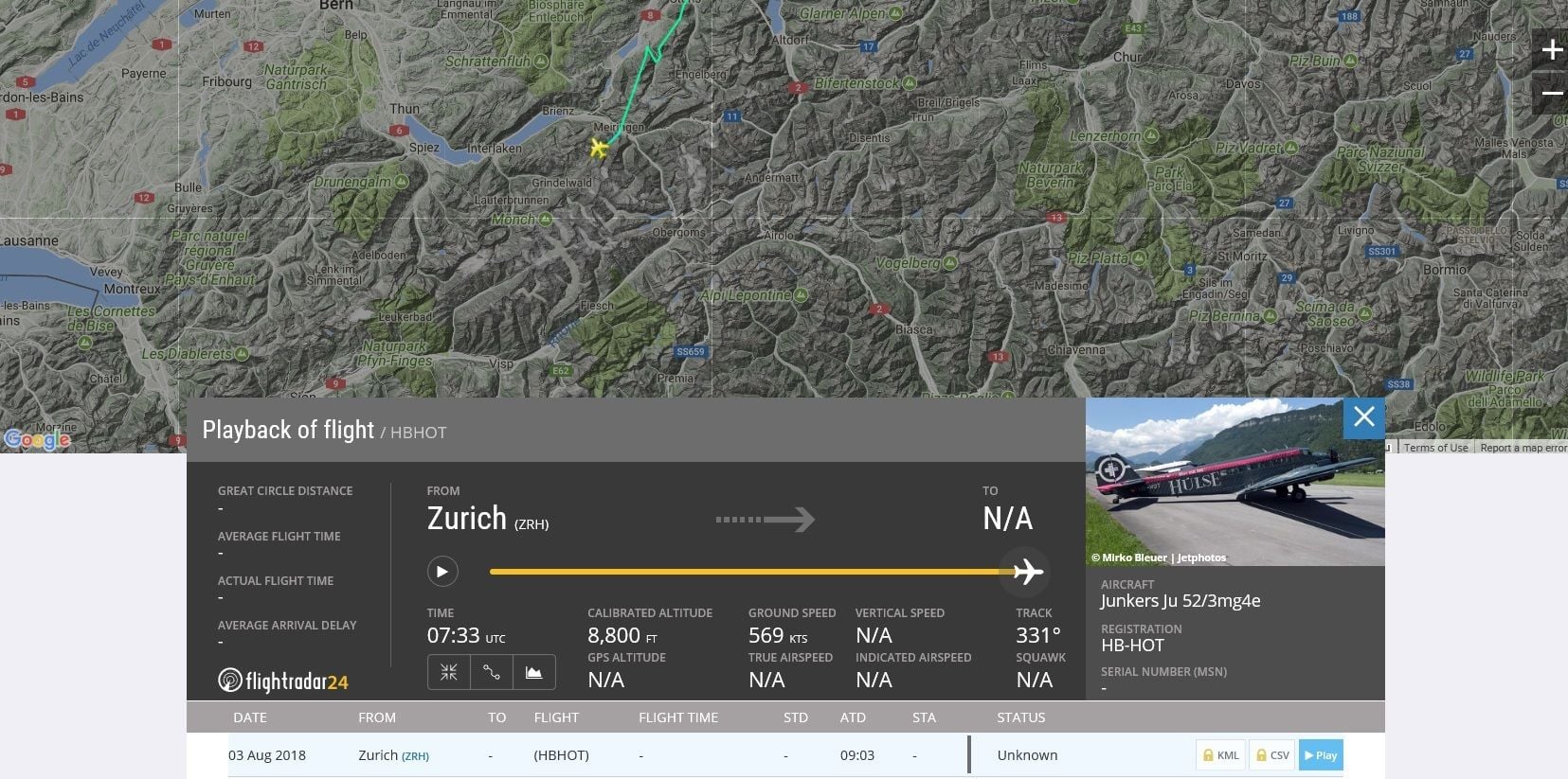
Second the flight from DUB to LOC was done in the morning of the 3rd August arriving in Locarno at 10.10 LT and the route was via Grindelwald, Aletsch Glacier, Gothard and Leventina Valley down to Locarno, so it didn't pass trough Segnespass.
Both are taken the 4th August and shows the Ju-52 (HB-HOT) during its last flight. The Panorama picture can't be sure at 100% but likely.
Regarding the picture which stated the last turn of the Ju before the crash, I read a lot of speculations regarding a fake picture or that it's the flight towards Locarno the day before, well please read the article in the Blick first: https://www.blick.ch/news/schweiz/au...id8700276.html
Second the flight from DUB to LOC was done in the morning of the 3rd August arriving in Locarno at 10.10 LT and the route was via Grindelwald, Aletsch Glacier, Gothard and Leventina Valley down to Locarno, so it didn't pass trough Segnespass.