


4th Aug 2018 Junkers JU52 crashed in Switzerland

At a high density altitude the relatively higher TAS would get you into a pickle more quickly in a box canyon than at lower altitudes.
At 1000ft AMSL 60kts IAS is 61kts TAS but at 10000ft AMSL it's 72kts TAS.
Would it be enough to make the difference and force a higher turn rate to avoid terrain, edging towards the stall in clean configuration?
At 1000ft AMSL 60kts IAS is 61kts TAS but at 10000ft AMSL it's 72kts TAS.
Would it be enough to make the difference and force a higher turn rate to avoid terrain, edging towards the stall in clean configuration?

Join Date: Jul 2009
Location: Down on Earth
Posts: 4
Likes: 0
Received 0 Likes
on
0 Posts
On the site of the webcam of Mutta Rodunda (just google it) cable car station you can have a look at the possible crash site if you go back in time 2018-08-04 to 16:40 and 17:00. Below the half-moon shape snow field you see nothing at 16:40, but possibly the JU52 at 17:00. The weather looks not too bad.
I would post the pictures, but I am not allowed to do so yet (less than 10 posts)
I would post the pictures, but I am not allowed to do so yet (less than 10 posts)
The "not so smokey" ju-52 is to the north west side of Piz Sengas
Thanks to various pointers to this location from poster(s).
From the Streetview viewpoint at this location you get the "grass/smoke" view of Piz Segnas.
https://goo.gl/maps/i2JBbsA3PtC2

Drag the yellow man towards the point.
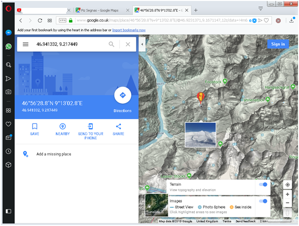
Drop the Yellow man's circle over the blue circle at the point.
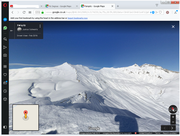
Pan right to about 155 degrees and zoom in to get the image below

From the Streetview viewpoint at this location you get the "grass/smoke" view of Piz Segnas.
https://goo.gl/maps/i2JBbsA3PtC2
Drag the yellow man towards the point.
Drop the Yellow man's circle over the blue circle at the point.
Pan right to about 155 degrees and zoom in to get the image below
Last edited by jimjim1; 7th Aug 2018 at 16:27.
Join Date: Apr 2017
Location: England
Posts: 75
Likes: 0
Received 0 Likes
on
0 Posts
On the site of the webcam of Mutta Rodunda (just google it) cable car station you can have a look at the possible crash site if you go back in time 2018-08-04 to 16:40 and 17:00. Below the half-moon shape snow field you see nothing at 16:40, but possibly the JU52 at 17:00. The weather looks not too bad.
I would post the pictures, but I am not allowed to do so yet (less than 10 posts)
I would post the pictures, but I am not allowed to do so yet (less than 10 posts)
16.40:
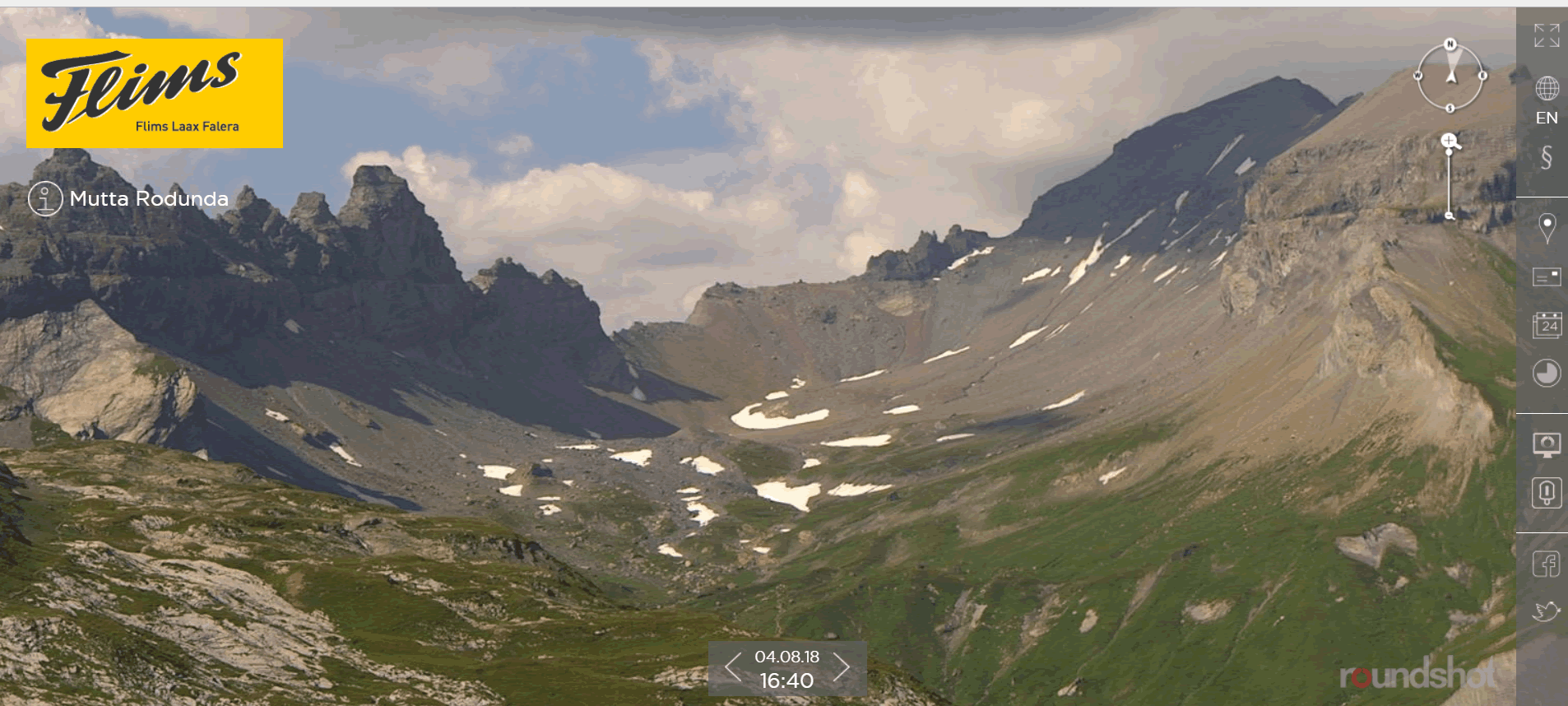
17.00:

Closeup of object, 17.00:
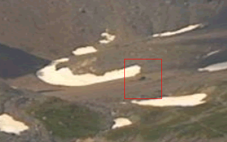
Can't get the resolution any better than that.
Just to put another cat among the pigeons, Aviation Herald is now quoting "a military pilot" who says he saw the same aircraft, 10 minutes prior to the accident, make a similar left turn that "suddenly" developed into a severe roll and dive, but recovered with high power.
Make of that what you will: Crash: Ju-Air JU52 at Piz Segnas on Aug 4th 2018, impacted terrain
Make of that what you will: Crash: Ju-Air JU52 at Piz Segnas on Aug 4th 2018, impacted terrain
Join Date: Oct 2017
Location: Vienna
Posts: 143
Likes: 0
Received 0 Likes
on
0 Posts
How about shifted COG which would cause the high pitch we see in the �smoke� photo and subsequential stall?
Could be as simple as too many people moving aft to see the view or whatever...
Could be as simple as too many people moving aft to see the view or whatever...
Guest
Posts: n/a
...PaxBritannica, I was about posting the same pictures (looking noth-north-east). Yes, sadly, it clearly shows where the Ju-52 ended. The 16.50 pictures shows shadow over the area so these two, at 16.40 and 17.00 are the clearest ones. With different infos so far available I agree with some other comments here, it was most probably a stall (left wing) accident. (My personal opinion!)
The distance between the mountain ridges is about 900m. In the left ridge we have the Martinsloch (round opening in the mountain). According to other info, ISA was around 17 degree over standard atmosphere. The wind (max almost 20 knots according other info) was from the north (from behind the ridge on the left side).
Now we have to options:
-1) the pilots on the way home, heading north, wanted to fly straight over the ridge (at the lowest point) , but realized that the performance was not good enough, so they were forced to turn back to the south...
or:
-2) the pilots first wanted to show the Martinsloch, flying north-north-east along the right mountainslope followed by a left turn back to the south.
- Considering the fully loaded aircraft, and high ISA +17, the TAS would be greater than at STD atmosphere resulting in a greater turning radius, and... to keep inside the valley they MAYBE had to increase the bank angle.
- At 45� bank the stall speed increase with 20% (1.4G). They most probably used max continues power. What speed? 120 knots? Or even slower (in case 2) due to terrain?
- The north wind, maybe gusting and turbulent, becoming a tailwind component during the last part of the 180 degree turn. It is not hard to imagine that they had small margins, not only scanning the instruments but also to look outside to keep clear of terrain.
I am also wondering, how is the Ju-52 accelerated stall behaviour? With max continues power, in a 30� (or 45�) bank? Probably not so nice. And how is the spiral stability, and what aileron position is required to keep a steady turn? Neutral? All factors influencing such a situation.
Join Date: Oct 2011
Location: NV USA
Posts: 260
Likes: 0
Received 0 Likes
on
0 Posts
Just to put another cat among the pigeons, Aviation Herald is now quoting "a military pilot" who says he saw the same aircraft, 10 minutes prior to the accident, make a similar left turn that "suddenly" developed into a severe roll and dive, but recovered with high power.
Make of that what you will: Crash: Ju-Air JU52 at Piz Segnas on Aug 4th 2018, impacted terrain
Make of that what you will: Crash: Ju-Air JU52 at Piz Segnas on Aug 4th 2018, impacted terrain
The "high power" sound may have been the prop overspeeding and causing severe drag on the left engine.
Pure speculation on my part of course.
Join Date: Jun 2009
Location: Switzerland
Age: 39
Posts: 56
Likes: 0
Received 0 Likes
on
0 Posts
https://www.blick.ch/news/schweiz/au...id8700276.html
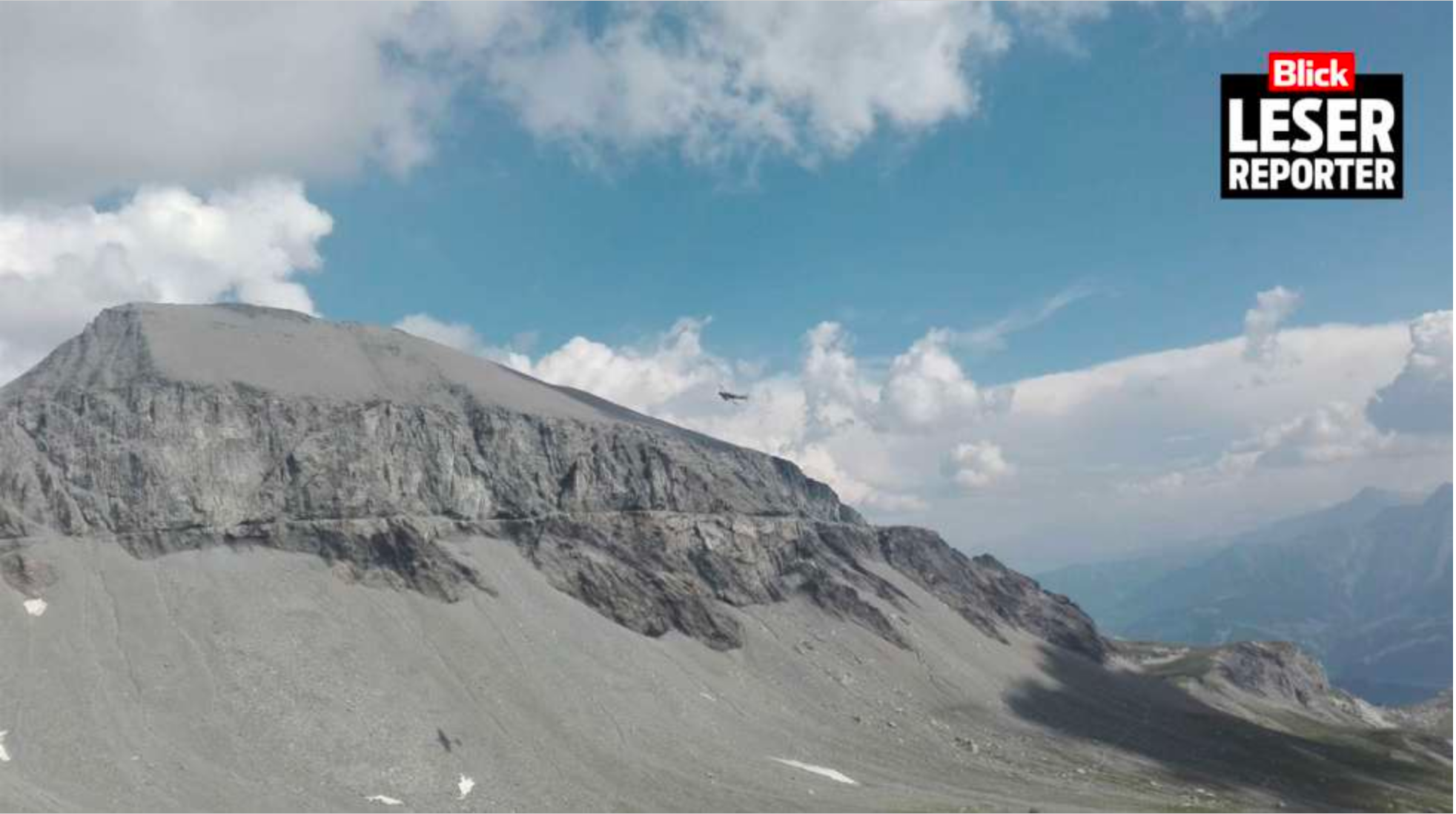
Also as far as we can judge from that picture the overall attitude seems about normal. We do get an idea of the terrain below, definitely not smooth but certainly somewhere you could try an emergency landing with such an aircraft in case of a catastrophic engine failure.
Now we have to understand why they apparently completely lost control. I remain perplexed.

Upwind or Downwind of the Ridge?
Upwind would be in updraft.
Downwind could be downdraft and nasty rotors.
Much depends on wind direction relative to terrain, strength and shears. You could be flying in a particular area for years without problems � and one day you get nailed.
Downwind could be downdraft and nasty rotors.
Much depends on wind direction relative to terrain, strength and shears. You could be flying in a particular area for years without problems � and one day you get nailed.
Join Date: Jan 2008
Location: Herts, UK
Posts: 748
Likes: 0
Received 0 Likes
on
0 Posts
You could be flying in a particular area for years without problems � and one day you get nailed.
Join Date: Oct 2011
Location: NV USA
Posts: 260
Likes: 0
Received 0 Likes
on
0 Posts
In the last Blick picture which looks to taken just seconds before the crash the JU52 appears to turning to the North into the wind and toward the headwall of the canyon. The torn white lower cumulus clouds behind it look like rotor clouds. Rotor clouds are a good indication of turbulence and mountain wave associated with wind across the mountain tops.
in the online newspaper Blick you can see the last picture of the Ju-52 in a left turn.
https://www.blick.ch/news/schweiz/au...id8700276.html
https://www.blick.ch/news/schweiz/au...id8700276.html
Good map of the area
My question would be how much reserve performance could they have flying there with a compliment of 20 passengers on a hot day. Apparently we have a few posters with actual JU52 experience. I would be very interested in their "real liffe" " findings.
Pegase Driver
Join Date: May 1997
Location: Europe
Age: 74
Posts: 3,682
Likes: 0
Received 0 Likes
on
0 Posts
A rumor in the hangars speaks about Carbon monoxide .But difficult to say if this another wild speculation or based on leaks on the first forensic tests..
I tend to go for the first option but maybe someone has more info as to where this rumor comes from .
I tend to go for the first option but maybe someone has more info as to where this rumor comes from .
Join Date: Jul 2009
Location: Down on Earth
Posts: 4
Likes: 0
Received 0 Likes
on
0 Posts
Join Date: Apr 2007
Location: EU
Posts: 28
Likes: 0
Received 0 Likes
on
0 Posts
Maybe the operator has access to more archive images. Just to be sure, I notified them...