


Missing Indonesian Aircraft

Join Date: Sep 2014
Location: Canada
Posts: 1,257
Likes: 0
Received 0 Likes
on
0 Posts
Reports that an AMA (Associated Mission Aviation) aircraft taking part in the SAR effort may have located debris thought to be TGN267 near the "Oskop waterfall" in the Bintang Mountain district, approx. 7nm from Oksibil.
(Indonesian)
Pesawat AMA temukan puing diduga Trigana di Oksop - ANTARA News
(Google Translate)
https://translate.google.com/transla...-text=&act=url
(Indonesian)
Pesawat AMA temukan puing diduga Trigana di Oksop - ANTARA News
(Google Translate)
https://translate.google.com/transla...-text=&act=url

Join Date: Jan 2015
Location: Near St Lawrence River
Age: 53
Posts: 198
Likes: 0
Received 0 Likes
on
0 Posts
In bad weather, the approach is quite a challenge
https://m.youtube.com/watch?v=TDlvpHQoj6M
https://m.youtube.com/watch?v=TDlvpHQoj6M
An interactive map of the incident area has been created and can be found at Trigana Air Service flight TGN267

Bad weather hampers bid to reach Indonesian plane crash site
This should produce an influx of willing local searchers on the land side
This should produce an influx of willing local searchers on the land side
Join Date: Mar 2014
Location: JAC Jackson Hole,
Age: 73
Posts: 27
Likes: 0
Received 0 Likes
on
0 Posts
$468,000.00 cash plus on plane for poor...
Join Date: Sep 2014
Location: Canada
Posts: 1,257
Likes: 0
Received 0 Likes
on
0 Posts
The spotted crash site was a bit west of the guestimated area, reported at 04 49.289 S 140 29.953 E, and an altitude of 8,300 ft. The chance of survivors is reported to be "very slim".
The SAR team consisting of National SAR members, police and military personnel plus local resident volunteers have been making their way to the site on foot.
However, the terrain is very difficult -- around 14 km hike in thick jungle, fog with visibility of less than 3 feet. The SAR team was not able to reach the crash site today and will resume the hike tomorrow.
Join Date: Dec 2000
Location: On the equator
Posts: 1,291
Likes: 0
Received 0 Likes
on
0 Posts
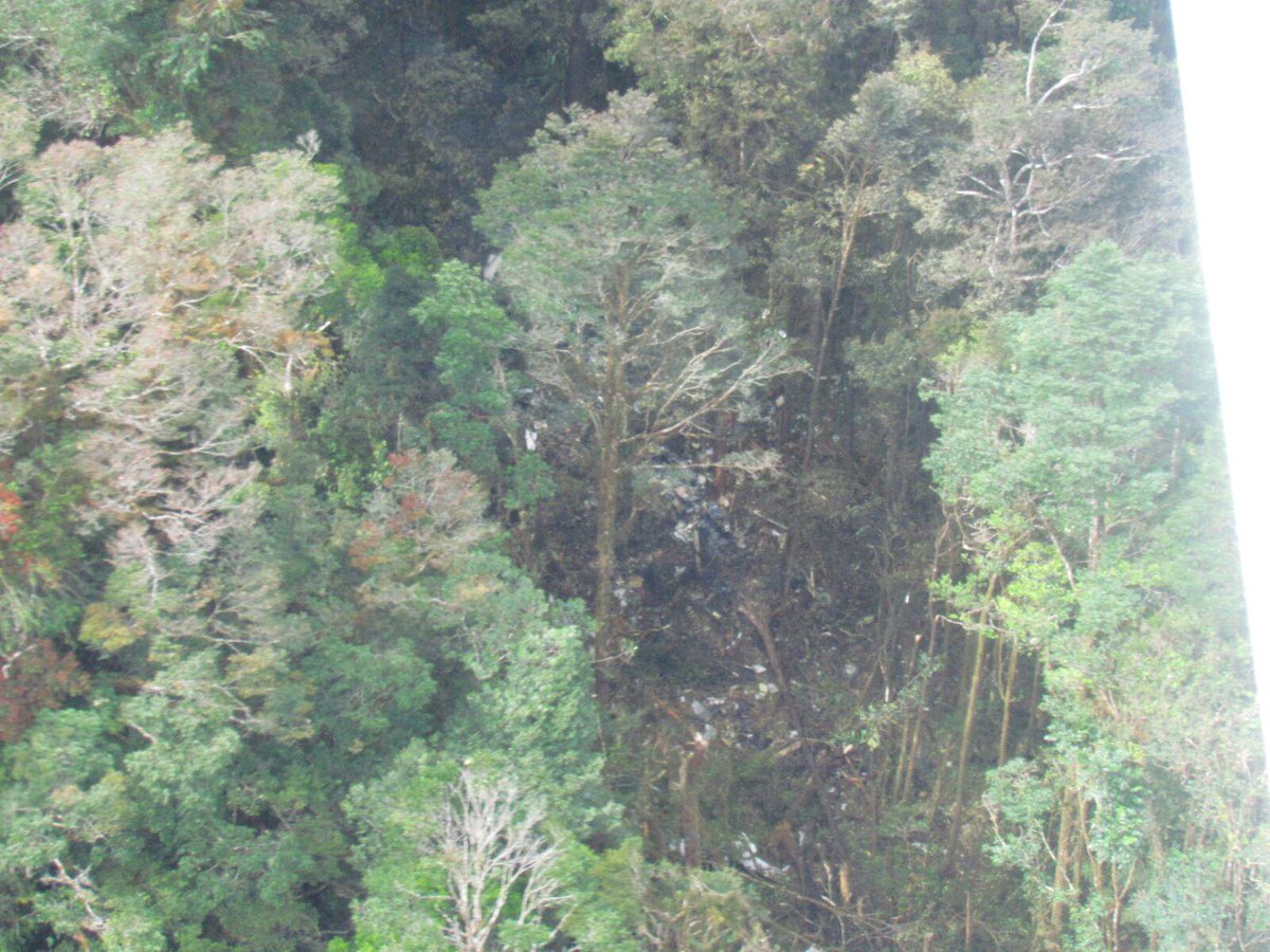
This is the crash site apparently;
There's apparently 1/2 million dollars in cash somewhere down there too, being carried for a family welfare fund according to local press.
Source: Twitter
There's apparently 1/2 million dollars in cash somewhere down there too, being carried for a family welfare fund according to local press.
Source: Twitter
A curiously narrow impact area for an ATR. I'd have expected to see wider tree clipping from the wings in a wings-level CFIT.
Could they have seen the terrain at the last second, pulled up too hard, stalled and rolled to wings vertical and nose down - similar to the final moments of the videoed ATR that crashed in Taipei?
http://www.thetimes.co.uk/tto/multim...5__849255b.jpg
Could they have seen the terrain at the last second, pulled up too hard, stalled and rolled to wings vertical and nose down - similar to the final moments of the videoed ATR that crashed in Taipei?
http://www.thetimes.co.uk/tto/multim...5__849255b.jpg

fog with visibility of less than 3 feet.
Somebody is exaggerating just a tad here.
Somebody is exaggerating just a tad here.

Join Date: Jan 2008
Location: Hotel Sheets, Downtown Plunketville
Age: 76
Posts: 0
Likes: 0
Received 0 Likes
on
0 Posts
This may not be the first for that route. Ironically it was in August 2009 when a DH-6 Twin Otter went down in the Gap. Here is the link for further info.
http://kemhubri.dephub.go.id/knkt/nt...t%20PK-NVC.pdf
http://kemhubri.dephub.go.id/knkt/nt...t%20PK-NVC.pdf
Join Date: Jan 2008
Location: london
Posts: 6
Likes: 0
Received 0 Likes
on
0 Posts
Even without the fog in high altitude rainforest three foot is abou5 as far as you can see. The most extraordinary denseness of plant life, very beautiful but like no other environment on earth.
Join Date: Mar 2015
Location: USA
Posts: 75
Likes: 0
Received 0 Likes
on
0 Posts
"fog with visibility of less than 3 feet.
Somebody is exaggerating just a tad here."
I have been in fog with that visibility in Colorado at about 8,000 ft. Take 2 steps from the person walking with you, stop talking, and they can't find you.
Somebody is exaggerating just a tad here."
I have been in fog with that visibility in Colorado at about 8,000 ft. Take 2 steps from the person walking with you, stop talking, and they can't find you.

curiously narrow impact area for an ATR
Having hiked in similar environments I can speak from experience, in low light conditions the three feet is not an exaggeration... Weather in tropical mountains changes incredibly fast, I can easily envision a scenario where they committed to a visual descent into a valley, and found themselves in IMC halfway through without a good plan B.
Last edited by andrasz; 19th Aug 2015 at 04:22.
Join Date: Nov 2004
Location: Perth - Western Australia
Age: 75
Posts: 1,805
Likes: 0
Received 0 Likes
on
0 Posts
What's the bet the 6.5 billion rupiah (AUD$637,443) carried in the aircraft, will be found to have all been burnt, and totally destroyed in the crash? 
