


Flaperon washes up on Reunion Island

Thread Starter
Flaperon washes up on Reunion Island
Similitudes incroyables entre le flaperon d'un #B777 et le débris retrouvé ce matin ŕ #LaReunion... #MH370 ? http://t.co/GDkzRLwi2h
Seems a piece of flap or similar has washed up on Reunion Island. Tweet says the similarities to a 777 part are incredible.
Thoughts?
Seems a piece of flap or similar has washed up on Reunion Island. Tweet says the similarities to a 777 part are incredible.
Thoughts?

There are several photographs of this debris at A-t-on retrouvé les premiers débris du MH370 ? | Sécurité aérienne et peur en avion
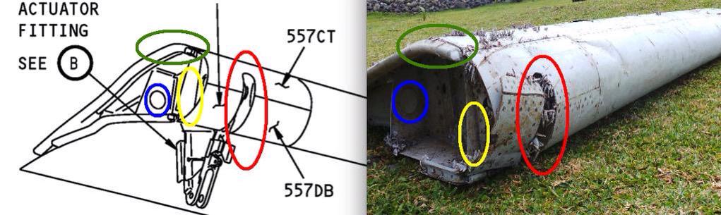
The part looks like a composite flaperon with damage more consistent with a slower speed impact.
The part looks like a composite flaperon with damage more consistent with a slower speed impact.
Join Date: Mar 2014
Location: JAC Jackson Hole,
Age: 73
Posts: 27
Likes: 0
Received 0 Likes
on
0 Posts
Another article + images
They should recheck the area surrounding where the pings were heard. There wasn't enough mapping done there. It is highly possible to have a distorted frequency towards the end of battery life.
NTSB simulation plots based on Great Circle Track where assuming the FMC would guide the autopilot system to fly. But with the aircraft had made a few turns, most likely the pilots had reverted to MCP direct input to the autopilot system where the track is magnetic be it on TRK SEL or HDG SEL, is subjected to high magnetic variation further down south. Thus, when the magnetic track being plotted would be a curve towards East. But a curve cannot satisfy the handshakes. If the handshakes are correct, this magnetic curve line can be "straighten" by lifting the tail end Northwards while maintaining all the handshakes relationship with the satellite position.
Just imagine the capital letter "T" with the handshakes numbering from the left to right, the position of the satellite is at the bottom of the vertical shaft and the letter T has fallen 90 degrees to the your right. Now you have handshake no.6&7 at the right hand bottom, you are lifting the "T" pivoting the bottom of the shaft to the satellite position. Try lift it until no.7 handshake ends up in less than 5 degrees variation. Then you will agree they have been looking too far down all this while.
Welcome any expert comment.
https://upload.wikimedia.org/wikiped...Ocean_Gyre.png
Based on where it is believed that the aircraft came down, and the combined drift / flow of the West Australian Current and the South Equatorial Current, Reunion Island is a reasonably likely place for something to wash up.
Will be interested to see if they can match this to the hull number.
Another depiction of ocean currents.
Flaperon washes up on Reunion Island
Just wondering: assuming (big if) it can be traced to mh370 - would that give us any further clue as of where to search the aircraft, except somewhere in the Indian Ocean?!
Join Date: Jun 2009
Location: Canada
Posts: 464
Likes: 0
Received 0 Likes
on
0 Posts
Beyond that, I'd imagine the variation of current and debris behaviour is so large that you couldn't really improve the accuracy of the current search.
Edit: I guess one possibility is that the damage might help determine how the aircraft hit the sea, which might help reduce the search area. For example, whether it hit in an uncontrolled impact, or whether it might have been flown down by someone in the cabin. One of the big issues for the search is not knowing how far from the final 'ping' the aircraft might have flown before it came down.
Last edited by MG23; 29th Jul 2015 at 18:52.
Join Date: Nov 2013
Location: California
Posts: 154
Likes: 0
Received 0 Likes
on
0 Posts
The piece looks way too short to be a flaperon from a B777. From the second photo in Telegraph article, it's at most 2.5 m long. B777's inboard flap is at least 5 m long. Either it got snapped in half (doubtful, since both edges look straight), or it's not from a 777.
Yemenia's Airbus 310 flap would be closer in terms of dimensions.
Yemenia's Airbus 310 flap would be closer in terms of dimensions.
Join Date: Jun 2009
Location: Canada
Posts: 464
Likes: 0
Received 0 Likes
on
0 Posts
The piece looks way too short to be a flaperon from a B777. From the second photo in Telegraph article, it's at most 2.5 m long. B777's inboard flap is at least 5 m long. Either it got snapped in half (doubtful, since both edges look straight), or it's not from a 777.
Also, from the damage, it would presumably have to be composite rather than metal? That might eliminate some other possibilities.
Join Date: Jan 2015
Location: Bremen
Posts: 1
Likes: 0
Received 0 Likes
on
0 Posts
777 flaperon is 2.4m * 1.6m
fits.
Boeing 777 - So fliegt man richtig - FlightX.net - das größte deutschsprachige Forum der Flugsimulation
fits.
Boeing 777 - So fliegt man richtig - FlightX.net - das größte deutschsprachige Forum der Flugsimulation