


Malaysian Airlines MH370 contact lost

Join Date: Oct 2009
Location: Australia
Posts: 367
Likes: 0
Received 0 Likes
on
0 Posts
as it is best understood
as provided by
Disparition du Vol MH370 : la zone de recherche étendue ŕ l?Océan Indien | Air Info
This is the path before adding on the new statement from the US/Malaysia team, which indicates around the end point of the plotted path one of two directions were taken - one in the SW direction toward MEMEK and one nearly due north toward SANAR
According to CNN, the US and India have basically determined one of those directions is where the plane will be found, and that is where the two Countries will be looking headed froward

Join Date: Dec 2013
Location: Paso Robles
Posts: 261
Likes: 0
Received 0 Likes
on
0 Posts
So, Yes, a crew could inadvertently make active a previous flight's route, very easily, in 2key presses of the FMC

Join Date: Jul 2007
Location: Germany
Posts: 1
Likes: 0
Received 0 Likes
on
0 Posts
Look at the route. It's not part of a recognised route structure. It's following the fir boundary. Why do this? Because if you want to cause max confusion, and you are in the know, you do this to play one airspace against the other, by flying along the boundary instead of,across it until you are outside of radar coverage.
Problem is, with the endurance they had, jet could be anywhere in the Indian Ocean.
Problem is, with the endurance they had, jet could be anywhere in the Indian Ocean.
Last edited by VinRouge; 14th Mar 2014 at 23:48.
Join Date: Mar 2004
Location: Origae-6
Posts: 137
Likes: 0
Received 0 Likes
on
0 Posts
Nice post Evey H
It's very easy to forget there are real people and real families who's lives have been changed forever. For the families involved I hope they have the answers they are looking for and deserve very soon.
Join Date: Dec 2013
Location: Paso Robles
Posts: 261
Likes: 0
Received 0 Likes
on
0 Posts
but we know the aircraft was flying for at least 5 hours
But per the CNN article and news video this graph ends where they either went North West or South East, watch the relevant CNN video, it is all there.
Join Date: Jan 2008
Location: Melbourne
Posts: 62
Likes: 0
Received 0 Likes
on
0 Posts
About twice a year, since I joined PPRuNe in April 1997, either Danny or Rob have explained why posts on threads such as this get deleted

Join Date: Aug 2011
Location: between the lines
Age: 44
Posts: 16
Likes: 0
Received 0 Likes
on
0 Posts
Does anyone here KNOW how often the ACARS- system on a 777 or on this 777 pings absent a response or ( contract ) to supply engine related data?
Join Date: Oct 2009
Location: South of the North Pole
Age: 67
Posts: 21
Likes: 0
Received 0 Likes
on
0 Posts
Navigate by the stars
Do you mean to tell me that pilots would not know to navigate by the stars?
Yes. It's not a commonly needed skill.
I am left without voice. It may not be a "commonly needed skill" but it's darn useful and I would have more confidence in flying if I knew that failing all equipment the pilots would know where they are and where they go... I was taught as a child, it's not that difficult, no need to be an astronomer...
It's a skill that could have come in handy to the pilots of MH370 on this moonless night without clouds.
Join Date: May 2013
Location: NJ
Posts: 1
Likes: 0
Received 0 Likes
on
0 Posts
Originally Posted by DWS
Does anyone here KNOW how often the ACARS- system on a 777 or on this 777 pings absent a response or ( contract ) to supply engine related data?
Note that BA claims no such contract- and RR also claims no ( engine? ) data after a few minutes before transponder shut down.
I suspect that some technical types consider DATA only to be ( engine parameters and the like ) and the non technical types do NOT consider a simple ping to be DATA … or vice versa depending on background.
And about 99 percent of the media pundits don't know the difference.
So when RR says NO engine data - they **probably mean ** no engine parameters- and do not count a ping per se as DATA
The press probably thinks or defines NO DATA as being NO pings
Yes its splitting hairs or whatever- but his old engineer would consider the ping as " hello- are you there " as an address or attempt to communicate and NOT DATA as its commonly used. I would consider altitude and speed and time as general DATA and Engine parameters as " engine " data .
Lacking one ( engine ) data IMO does NOT mean NO DATA if altitude and speed are part of the transmission.
Back to my question does anyone KNOW the ping repitition rate or ( try every xx minutes or seconds and if no answer to dump data, try again in xx minutes ) ???
The airline and nation are probably n complete shock about the only conclusion you can draw from this.
Otherwise there could be an unread note, left on the kitchen table?
Mickjoebill
Join Date: Apr 2008
Location: Sydney
Posts: 27
Likes: 0
Received 0 Likes
on
0 Posts
I think people are thinking far too much into this tragedy.
My belief is it was a simple catastrophic event most probably a serious raging fire and the aircraft was pulverised into tiny pieces upon hitting the sea near its original track.
There have been a few instances in history where that has happened where it left very little debris floating.
My problem with the hypoxia then anoxia theory is should the aircraft had headed west over the malay peninsula, crowded airspace with the transponder off then how come no atc controllers on duty in the area noticed it with primary paint and made a song and dance about an unidentified aircraft being in their airspace. Sure a military facility claims they painted the aircraft but that is not officially released info. If the military painted it then so would the civvies.
I believe this current preoccupation with engine or airframe reporting picked up by inmarsat may again be over-reaching. Are inmarsat absolutely 100% sure they were listening to the accident aircraft? How do they know MAS hasnt been swapping systems on the planes for maintenance and the system registered to mh370 was not on another plane?
As for the terrorism angle, excepting 9/11, most terrorists want to announce to the world what they are trying to achieve, not cloak and dagger so turning off transponders etc... Achieves what advantage for them?
The vast majority of accident sequences end up being very simple indeed. Anything else requires complexity that is outside the limits of most people.
Join Date: Jan 2008
Location: Kent
Age: 65
Posts: 216
Likes: 0
Received 0 Likes
on
0 Posts
If any of this turns out to be true, you can see why the Malaysians were flustered. They start off with something that looks like a 'straightforward' destruction /crash, then are gradually presented with a bunch of facts that add up to something almost beyond belief. You'd hardly want to go public with this and look like mad people. The internal arguments must have been fierce.
Join Date: Dec 2013
Location: Paso Robles
Posts: 261
Likes: 0
Received 0 Likes
on
0 Posts
Nor would they be able to use the sun by day?
It's a skill that could have come in handy to the pilots of MH370 on this moonless night without clouds.
There is absolutely zero evidence that these pilots got lost or could no longer navigate.
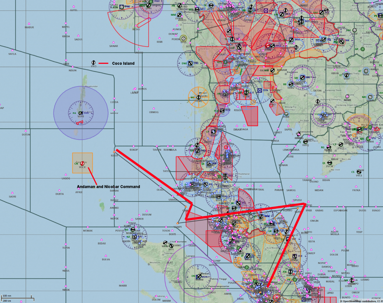
What FIR boundaries?
My aviation maps for that area do not show the boundaries as depicted in the image p.j.m reposted, only some of the lines (few of them in fact) delineate between Chennai (VOMF), Kuala Lumpur (WMFC), Jakarta, Yangoon and Bangkok (VTBB) FIRs. By leg:
- IGARI-VAMPI crosses in and out of VTBB/WMFC FIRs
- VAMPI-GIVAL follows no boundary and remains inside WMFC FIR
- GIVAL-IGREX remains well inside WMFC.
All based on the (current) SkyVector Hi/Lo alt enroute charts.
What sort of chart was used by the OP?
- IGARI-VAMPI crosses in and out of VTBB/WMFC FIRs
- VAMPI-GIVAL follows no boundary and remains inside WMFC FIR
- GIVAL-IGREX remains well inside WMFC.
All based on the (current) SkyVector Hi/Lo alt enroute charts.
What sort of chart was used by the OP?
Join Date: Oct 2009
Location: Australia
Posts: 367
Likes: 0
Received 0 Likes
on
0 Posts
Personally, I think we need security beefed up, and on high alert at the current point in time.
Join Date: Jan 2006
Location: US
Posts: 2,205
Likes: 0
Received 0 Likes
on
0 Posts
You will not notice turns using 5 degrees of bank UNLESS you are looking outside and using stars for reference when the turn starts.
You will not notice very small rates of climb(100-200' FPM).
The changes are so small if you feel the initial movement, doubtful, if it stays at that pitch or bank attitude for a long time your body will use the increased G (from the 5 degree bank) or slightly increased pitch attitude, as the new baseline.
The best odds of noticing small changes would be if you're standing. Most people don't notice the G loading change, felt as a weight increase, during turns unless they are standing. Your body is more in tune to the weight or pitch changes when you're standing vs. when you're sitting.
Join Date: Oct 2009
Location: Australia
Posts: 367
Likes: 0
Received 0 Likes
on
0 Posts
true, however if indeed there is SATCOM telemetry for 5 hours, that would prove at least 5 hours of flight.
We don't know Inmarsat's reception coverage (although we'd like to think they can receive SATCOM anywhere), we do know the aircraft had around 7 hours worth of fuel.
We don't know Inmarsat's reception coverage (although we'd like to think they can receive SATCOM anywhere), we do know the aircraft had around 7 hours worth of fuel.