


Malaysian Airlines MH370 contact lost

Join Date: Oct 1999
Location: United Kingdom
Posts: 141
Likes: 0
Received 0 Likes
on
0 Posts
If this is true, as its an Air Defence system, why were air defence assets not launched to intercept the contact?
As I said many, many posts ago, that particular chain of events could very easily lead to one very unpalatable outcome - one that no country would want to admit to. Such a scenario would best be subsequently handled by having everybody search on one area, whilst you clean up the mess in another.

Tailgating
Re: the tailgating theory. What's the max separation the tailgater can have from the tailgatee, horizontally and vertically, to appear on radar as a single a/c?
Join Date: Mar 2014
Location: Australia
Posts: 6
Likes: 0
Received 0 Likes
on
0 Posts
On Communications
Hello! I'm a telecommunications architect from Australia. I don't work in the aviation industry, so I will endeavor to only discuss components pertinent to my expertise. If anything that I say is incorrect, please notify me so that I can update my correspondence to reflect this.
Both TelcoAG and snowfalcon2 appear to be on the money. Specifically, snowfalcon2 posted:
By my own admission, I am not familiar with the TDMA signalling used on the Inmarsat-C communications platform, but it is my understanding that the signalling channels are also TDMA, meaning that it is highly likely that delta-T between timeslot allocations for handshaking as received by the two birds is how the speculative great circles have been generated.
Spot beams tend to be focused over areas where capacity constraint becomes an issue. Shaped beams (covering greater surface area) are used over sparely populated areas (such as oceans) because of the lower capacity requirements in these areas and the lack of business case for cost recovery in investing in additional hardware and power requirements on the space platform to accommodate underutilized transponders.
There has been a lot of speculation in the thread regarding the use of the SATCOM on the AC to communicate with ground crew in a hypothetical scenario where the person or people who have intervened in the operation of the aircraft intended to land it. Whilst it is true that the airframe of an aircraft is a decent Faraday cage, a pair of 5W VHF radios with a small antenna near the window of the flight deck would be sufficient to establish voice communications with a ground crew.
Both TelcoAG and snowfalcon2 appear to be on the money. Specifically, snowfalcon2 posted:
3. A third method may be to utilize the "Time Alignment" procedure that is widely used in e.g. GSM. [snip]
The caveat with this method, hovever, is that it is normally used only when you actually establish a connection to send a payload. For a periodic "ping" you normally don't need to allocate a timeslot.
The caveat with this method, hovever, is that it is normally used only when you actually establish a connection to send a payload. For a periodic "ping" you normally don't need to allocate a timeslot.
4. It is quite conceivable that the Inmarsat satellite can measure the "elevation angle" of the received signal directly. Newer satellites have narrow individual "spot beams" to increase capacity, and obviously the system can keep track of which beam is allocated to any particular transmission.
There has been a lot of speculation in the thread regarding the use of the SATCOM on the AC to communicate with ground crew in a hypothetical scenario where the person or people who have intervened in the operation of the aircraft intended to land it. Whilst it is true that the airframe of an aircraft is a decent Faraday cage, a pair of 5W VHF radios with a small antenna near the window of the flight deck would be sufficient to establish voice communications with a ground crew.
Last edited by TelcoAUS; 15th Mar 2014 at 10:47.
Join Date: Sep 2007
Location: Australia
Age: 70
Posts: 6
Likes: 0
Received 0 Likes
on
0 Posts
Spot on TelcoAg
I'll guarantee you one thing though - every hour spent by an RF engineer to limit that range saves somewhere on the order of half a day's worth of ocean to cover.
This is an incredibly complex system with limited knowledge of all of the variables.
To describe the difficulty, it would be like me asking you to find out which cows your hamburger came from after visiting a random McDonalds. You could probably limit it down to a few slaughter houses, but you'd never be able to pinpoint the cows.
Join Date: Dec 2005
Location: At home
Posts: 244
Likes: 0
Received 0 Likes
on
0 Posts
Is there any valid reason why transponders can be switched off?
If not then all transponders should be armed and locked immediately so they cannot be switched off ever again!!
If not then all transponders should be armed and locked immediately so they cannot be switched off ever again!!
I have seen two reasons so far.
1. in case of equipment fire there has to be a means to cut electrical power to the equipment.
2. malfunction of the transponder sending out garbled signals that block the radar system and may create chaos for ATC.
Now, as the question is very likely to be addressed in the accident report,
how could these risks be mitigated?
Re (1), while I concur the fire risk is high priority, I think electronics design has made significant progress since the 777 was designed and certified in the early 90s. Power consumption is less, "design for safety" has improved, and it is becoming commonplace to design circuitry that monitors over-temperature and shuts down automatically. Just look at all effort done in electric cars nowadays. (Yes there have been some well publicized fires, but they mask the fact that in the vast majority of events the overtemp protection works. And a transponder draws far less power than an electric car.)
Re (2), unfortunately the type certification processes tend to hamper innovation and progress. But there are some potential relatively easy design fixes such as replacing "hard" power on/off switches with momentary reset buttons, such as e.g. in laptop computers.
Going one step furher one may have a networking between devices so that a shutdown or standby of the active transponder automatically turns on the redundant transponder, or at the very least sends a fault message on ACARS.
Considering the whole world's attention to this incident, it seems certifiers may come under some strong pressure to establish more tamper-proof datalinks in order to not let any more airliners vanish. The technology is already existing.
Last edited by snowfalcon2; 15th Mar 2014 at 10:55. Reason: typo
Join Date: Jul 2008
Location: Bali, Indonesia
Posts: 264
Likes: 0
Received 0 Likes
on
0 Posts
I have operated SIN LHR for the last few years routing over KL, Port Blair then over Calcutta. The new info about this flight being flown over this similar route makes we wonder if it "tailgated" such a flight heading towards India.
Last edited by philipat; 15th Mar 2014 at 10:58.
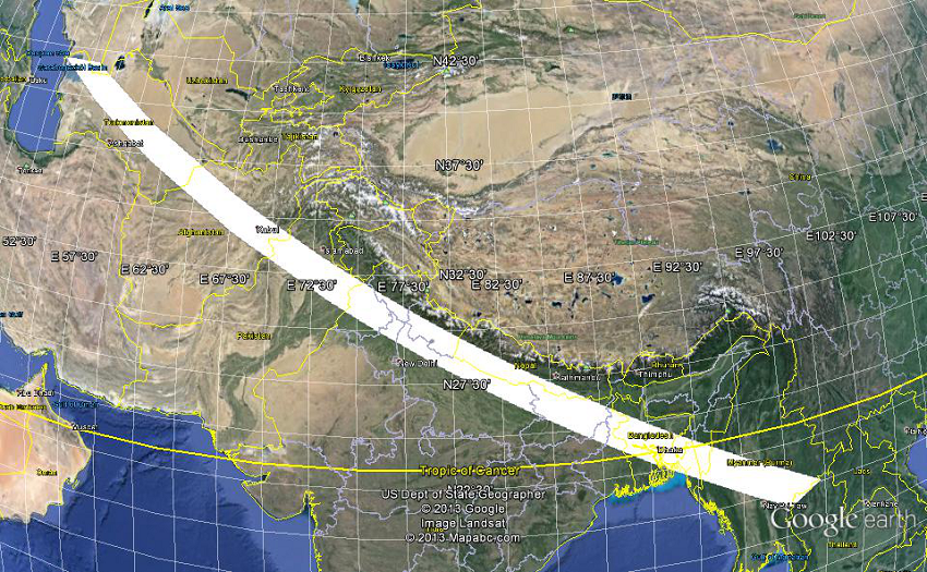
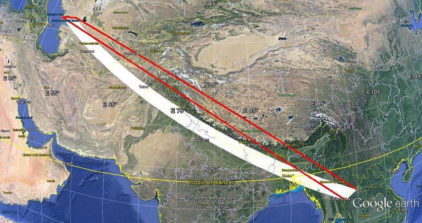
Position lines - estimated roughly
The images do NOT show tracks.
The images do NOT show tracks.
The images do NOT show tracks.
The primary purpose of this post is to indicate using symmetry the location of the southern position line. It is a LONG way from anywhere.
The diagram shows a representation of an estimate of the two position lines (with uncertainty) described in the press conference as being the position lines indicated by the last received "ping".
Since the satellites are geostationary, that is above the equator, I have assumed that the two lines are symmetrically disposed about the equator.
The two lines are based on the PMs statement; "a northern corridor stretching approximately from the border of Kazakhstan and Turkmenistan to northern Thailand", a *random* line between the two points (generated by Google Earth), and a southern copy of that line reflected in the equator.
The last image shows an additional alternate random position line between the two points. The white rectangle was drawn with the Google Earth "add polygon" tool with four points and the orange line with the "add path" tool with four points.
Please note:-
The images do NOT show tracks :-)))))
Hopefully a mathemetician will be along in a minute to explain the correct shape of the lines.
Two estimated position lines for the LAST "ping".
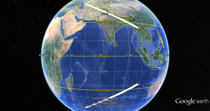
Northern
Southern
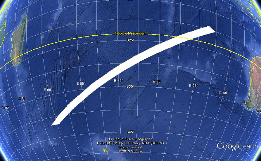
Alternate northern - showing an alternative estimated line.
Higher resolution versions are available at (hopefully):-
http://i783.photobucket.com/albums/y...copter/malasia
The images do NOT show tracks.
The images do NOT show tracks.
The primary purpose of this post is to indicate using symmetry the location of the southern position line. It is a LONG way from anywhere.
The diagram shows a representation of an estimate of the two position lines (with uncertainty) described in the press conference as being the position lines indicated by the last received "ping".
Since the satellites are geostationary, that is above the equator, I have assumed that the two lines are symmetrically disposed about the equator.
The two lines are based on the PMs statement; "a northern corridor stretching approximately from the border of Kazakhstan and Turkmenistan to northern Thailand", a *random* line between the two points (generated by Google Earth), and a southern copy of that line reflected in the equator.
The last image shows an additional alternate random position line between the two points. The white rectangle was drawn with the Google Earth "add polygon" tool with four points and the orange line with the "add path" tool with four points.
Please note:-
The images do NOT show tracks :-)))))
Hopefully a mathemetician will be along in a minute to explain the correct shape of the lines.
Two estimated position lines for the LAST "ping".
Northern
Southern
Alternate northern - showing an alternative estimated line.
Higher resolution versions are available at (hopefully):-
http://i783.photobucket.com/albums/y...copter/malasia
Join Date: Jan 2008
Location: uk
Age: 68
Posts: 29
Likes: 0
Received 0 Likes
on
0 Posts
Spectators Balcony
I have started a new thread in Spectorors Balcony for those of us who are not Professional Flightcrew to ask questions and speculate. Hopefully that will reduce the number of posts here and make the thread more useful.
Join Date: Jul 2009
Location: Planet Earth
Posts: 91
Likes: 0
Received 0 Likes
on
0 Posts
Update
A quick update to keep us focused:
Official Confirmed
01:07 Last routine engine data transmission
XX:XX ACARS disabled
01:17 Sign off Subang ATC
01:21 Xpndr switched off (near IGARI)
01:21 Malasian military PSR picks up MH370 at IGARI
XX:XX MH370 moves towards VAMPI and then towards GIVAL
02:15 MH370 turns towards IGREX and is lost on Malasian military PSR
08:11 Last ACARS handshake signal detected
Official Unconfirmed
08:11 A/C somewhere between border of Kazakhstan and Turkmenistan to northern Thailand
08:11 A/C somewhere between Indonesia and the southern Indian ocean
Unofficial Unconfirmed
XX:XX Altitude excursions at IGARI of unidentified PSR target (leak, via NYT)
Rumors
Everything else
Last edited by CogSim; 15th Mar 2014 at 11:09. Reason: Formatting
Props are for boats!
Join Date: Oct 2000
Location: An Asian Hub
Age: 56
Posts: 994
Likes: 0
Received 0 Likes
on
0 Posts
What I am saying Stormy is that final ping to the Satellite at 8:11 am came from the wreckage in the South China off Veitnam. Which is on the 40 degree line. It doesn't show up on your picture because it's faded. But I saw it when Jim Clancy showed his picture in front cameras this afternoon after the news conference.
Join Date: Jun 2007
Location: Highbury, London
Age: 66
Posts: 61
Likes: 0
Received 0 Likes
on
0 Posts
The pilot thickens.
Just out of curiosity, is there any public record of the last known conversation beyond the "Roger that" bit we've been allowed to know of? What was being acknowledged by that phrase?
Just out of curiosity, is there any public record of the last known conversation beyond the "Roger that" bit we've been allowed to know of? What was being acknowledged by that phrase?
Join Date: Mar 2014
Location: Perth
Age: 61
Posts: 65
Likes: 0
Received 0 Likes
on
0 Posts
Thanks jimjim1
The corridors should be along a large circle of radius 4840 km (as measured on the Earth's surface) centred on a point on the equator at 64 degrees east.
This is the point below the INMARSAT IOR which has been doing the receiving of pings.
I have not been able to draw postable diagrams yet these are close to yours.
The explanation for this is spread over several pages of previous posts by myself and several others especially including a photo of a map from the SAR authorities.
Join Date: May 2004
Location: Netherlands
Posts: 36
Likes: 0
Received 0 Likes
on
0 Posts
Radio contact with MH88
(Sorry if this has been posted before)
In the New Straits Times, an anonymous 777 pilot was quoted saying he had radio contact with MH730 on 121.5 MHz at 01:30LT (17:30Z), 8 mins after loss of radar contact. The NST report says that the pilot was over Vietnam, 30 mins ahead of MH730 with destination Narita, Japan. Data from Flightradar24 suggests that this flight in contact with MH730 may have been MH88.
MH88 on Flightradar24
The MH88 pilot said to NST that he was sure he was talking to the co-pilot of MH370.
Join Date: Mar 2014
Location: Australia
Age: 64
Posts: 1
Likes: 0
Received 0 Likes
on
0 Posts
Do I rightly recall that a friend of the Captain met him through 'political activism?'
If so, what exactly was meant by that? Does it mean that the guy handed out leaflets at his local supermarket against cutting down trees? Or was he a fully fledged campaigner for any one of a number of contraversial/extremist organisations whose names hardly need to be spelt out?
In the light of current developments, I can't believe this isn't a focus by someone, somewhere; it seems to have never been more relevant. Or - given the speculation by some about planesnatching, installing 'dirty bombs' and the like, is the extent of his extracurricular actvities too alarming for us to know the details?
Conversely if his activities were only small fry, I'd expect his family to want to see this cleared up.
Join Date: Mar 2014
Location: Perth
Age: 61
Posts: 65
Likes: 0
Received 0 Likes
on
0 Posts
Sheep Guts
The south china sea is on the 40 degree (satellite altitude) line as you say.
However, it is not included in the final 8:11am locations (marked in red on the Malaysian photo) because that area is also covered by another INMARSAT doing ACARS coms (called POR which is over the Pacific).
If the plane had ended up there then the pings would also have been picked up by POR. Obviously they were not hence the corridors start West of south-east asia.
You can see a map of INMARSAT coverage back a few pages or just search on google.
As the current thinking is moving away from an accident to a willful act, all the possible scenarios have one thing in common: they require a good deal of planning and preparation with nothing left to chance, and the kind of impeccable timing that one can see in a Mission: Impossible movie. Such preparation needs both time and money, and likely involved a number of people. It is very clear that any such planning must have involved this particular flight, as a number of key parameters (eg. takeoff time, initial flight path, fuel endurance, etc.) are unique to this flight only. I think it is also no coincidence that a moonless sky was chosen.
The key emerging question is why this particular flight would have been chosen as the target of such a massive investment and effort. I can think of several countries in the region where security procedures are much more lax (speaking of experience, will say no more), I can think of several airports on the border of oceanic zones where it is much easier to slip away from primary radar, etc.
Clearly understanding the motives is the key to the puzzle, as it is drifting away from being a purely aviation matter to something of much broader implications.

