


Malaysian Airlines MH370 contact lost

Join Date: Jun 2009
Location: NNW of Antipodes
Age: 81
Posts: 1,330
Received 0 Likes
on
0 Posts
@rh200,
You are absolutely right. That timing will produce a position line (in this case a curved one) and the originating signal will be somewhere along that line.
IMHO that is the clear reason why the authorities are talking about either to the NW or the SW. If the reason to go SW was a "terminal" one, then a very deep spot in the Indian Ocean would be a likely outcome. The reason to go NW, would probably be politically based. Take your pick.
Could the logs just be time tagged when the ping was recieved.
IMHO that is the clear reason why the authorities are talking about either to the NW or the SW. If the reason to go SW was a "terminal" one, then a very deep spot in the Indian Ocean would be a likely outcome. The reason to go NW, would probably be politically based. Take your pick.

It would be interesting to find out if there was an abnormally large discretionary uplift above the flight plan fuel. That might point to a deliberate attempt to extend the range.
Join Date: Mar 2014
Location: Perth
Age: 61
Posts: 65
Likes: 0
Received 0 Likes
on
0 Posts
A detailed post of mine about how to use INMARSAT satellite coverage to narrow down the location of signals has not appeared yet after I posted it.
However, a brief extra point is that, even with just one ACARS satellite communicating with you (which is the case over most of the Indian Ocean and subcontinent), you can determine distance (from signal to satellite) quite accurately from ping times (as there are usually several time-stamped messages going each way).
However, a brief extra point is that, even with just one ACARS satellite communicating with you (which is the case over most of the Indian Ocean and subcontinent), you can determine distance (from signal to satellite) quite accurately from ping times (as there are usually several time-stamped messages going each way).
Amazing fact !!
The police have only just started searching the aircrew's houses some 8 days - read that again - 8 days after the event.
We discussed this course of action on about page 2 - why are they just starting to check the "obvious"??
The police have only just started searching the aircrew's houses some 8 days - read that again - 8 days after the event.
We discussed this course of action on about page 2 - why are they just starting to check the "obvious"??
Props are for boats!
Join Date: Oct 2000
Location: An Asian Hub
Age: 56
Posts: 994
Likes: 0
Received 0 Likes
on
0 Posts
They need now to do a live test with B777 fly it on the same track with all radar and facilitates watching and recording and see if the can replicate what the THINK they have already!! I'm sure if they do this they will eliminate or confirm their assumptions to date. Otherwise the search windows are too large and there are not enough assets worldwide to cover such a large search zone.
Join Date: Mar 2014
Location: Houston
Posts: 9
Likes: 0
Received 0 Likes
on
0 Posts
anybody wondering what took them so long to let us know the possible new tracks the aircraft may have taken, Inmarsat data, etc?
Imagine you're holding your cellphone, and some guy looking at two towers worth of signal strength data is asked to find you. In a 2-d world it wouldn't be that difficult. I could pretty easily nail you down to two points. But now, get in an elevator, and I'm going to have a hell of a time mapping your movement.
In this scenario, going only off received signal strength data between two satellites, I have to figure out a boundary for a high and low signal that I want to say you crashed in. Now I look at all of the other data but some critical pieces are missing. I don't know how fast you were moving between two points when the satcom pinged, I don't know your changes in altitude, and on top of that, I don't know what interference or noise could've been introduced into the system at any given time by your environment or your actions on the plane.
I'll guarantee you one thing though - every hour spent by an RF engineer to limit that range saves somewhere on the order of half a day's worth of ocean to cover.
This is an incredibly complex system with limited knowledge of all of the variables.
To describe the difficulty, it would be like me asking you to find out which cows your hamburger came from after visiting a random McDonalds. You could probably limit it down to a few slaughter houses, but you'd never be able to pinpoint the cows.
Join Date: Oct 1999
Posts: 134
Likes: 0
Received 0 Likes
on
0 Posts
Communicator
Don't know how to paste your post here.
If that's the case (Satellite com/data system still "pinging" satellite after ACARS/CPDLC/ADS-C turned off) then the authorities would know how long the 777 system was active for. Is this the case?
Don't know how to paste your post here.
If that's the case (Satellite com/data system still "pinging" satellite after ACARS/CPDLC/ADS-C turned off) then the authorities would know how long the 777 system was active for. Is this the case?
Join Date: Sep 2001
Location: Connecticut, USA
Age: 64
Posts: 252
Likes: 0
Received 0 Likes
on
0 Posts
If the climb to F450 and then the erratic descent to ~F230 is true, it looks awfully like someone was at the controls who was finding that the real thing wasn't quite the same as Flight Sim. and it took him a while to get his head around handling it.
Join Date: May 2012
Location: Australia
Posts: 131
Likes: 0
Received 0 Likes
on
0 Posts
The Two Possible Flight Corridors...
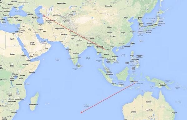
Source: NewsBreaker @NewsBreaker 1h
MAP: Shows 2 possible corridors that Malayasian Prime Minister mentioned for flight #MH370 pic.twitter.com/rv3q3FFA4e - @KHOLMESlive
Join Date: Sep 2009
Location: Internet
Age: 47
Posts: 43
Likes: 0
Received 0 Likes
on
0 Posts
I think it is safe to say the IAF has sufficient coverage to pick up a T7
IAF scrambles Su-30MKI after spotting UFO near Amritsar border
IAF scrambles Su-30MKI after spotting UFO near Amritsar border
latest Press conf
Malaysian PM says seems the US NTSB, FAA and our own UK AAIB are working on the data too and concur
Malaysian PM says seems the US NTSB, FAA and our own UK AAIB are working on the data too and concur
Join Date: May 2012
Location: Australia
Posts: 131
Likes: 0
Received 0 Likes
on
0 Posts
Last Satellite communication was seen at 8:11am Malaysian time (GMT+8)
but the sea is 4000m deep where they are now searching
Join Date: May 2012
Location: Australia
Posts: 131
Likes: 0
Received 0 Likes
on
0 Posts
Last location reported to be somewhere on the red lines...(the 40 degree lines)
This looks more logical, but the lines appear to be angulation related stopping at 0...
The angle appears to be the angle from the ground to the satellite, so 0 the satellite would be at the horizon.
So these 40 degree arcs is what the PM was referring to? & of course they are not a track, it is just that the last received signal was on these arcs somewhere.
Would the 40 degrees be determined by received signal strength as suggested?
Join Date: Feb 2001
Location: Pub
Posts: 122
Likes: 0
Received 0 Likes
on
0 Posts
As a Professional Pilots forum, these fanciful posts are embarassing. Heists, gold bullion, conspiracies. If you haven't anything sensible to post may I request you desist or join a different forum for fictional creative writing. 200 pages of posts, mostly drivel. Thanks to those few who have the expertise to elaborate on the facts.
Join Date: Jun 2009
Location: sydney
Posts: 3
Likes: 0
Received 0 Likes
on
0 Posts
All BS to date.
Come on people - I haven't seen anything posted in this discussion that remotely resembles anything professional, from pilots or rumour. It's all guessing and what-ifs. Why not hold off until you really have something? What is MAS senior staff really thinking and doing? What are the Malaysian armed forces holding (if anything?). What detail is available from other sensors (US etc) throughout the area? Somebody out there knows some of that detail....but I haven't seen it from anyone to date in this thread.
Join Date: Mar 2014
Location: Perth
Age: 61
Posts: 65
Likes: 0
Received 0 Likes
on
0 Posts
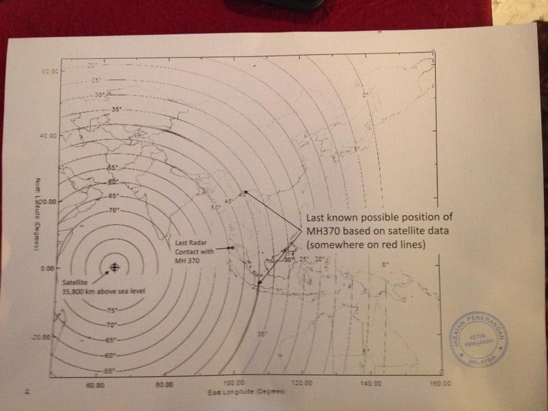
The INMARSAT which must have been involved in the last hours of pinging communication must have been IOR which is geostationary above the equator at 64 degrees east. (This is the only INMARSAT which deals with ACARS comms which has coverage over the longitudes that the plane was in then).
As I have said before, there would be no triangulation, just (accurate) distance information gleaned from the time to negotiate a single ping (a few short messages backwards and forwards).
The announced northern corridor (N Thailand to Kaz/Tkm) tells us that the distance measured from the final (8:11am) pings was about 4550 km as measured on the earth's surface (to a spot below the satellite). That is how far those two ends of the corridor are from the spot.
So the possible 8:11am locations lie on a circle of that radius around that spot.
I will post a map shortly.
Interestingly, also on that circle, within the northern corridor is Hotan.
Join Date: Jul 2008
Location: Bali, Indonesia
Posts: 264
Likes: 0
Received 0 Likes
on
0 Posts
I have operated SIN LHR for the last few years routing over KL, Port Blair then over Calcutta. The new info about this flight being flown over this similar route makes we wonder if it "tailgated" such a flight heading towards India.
That asssumes the NW track, which would logically be more likely in the case of piracy. IMHO, that is less likely than the SW track, more likely in the event of a suicide mission by a party or parties unknown and for unknown reasons. The US has already deployed assets to the IO and, I'm sure Submarines will already be lurking thereabouts also.