


Malaysian Airlines MH370 contact lost

Join Date: Apr 2005
Location: Stoke on Trent
Posts: 19
Likes: 0
Received 0 Likes
on
0 Posts
This website gives wind and water current details.
earth :: an animated map of global wind and weather
earth :: an animated map of global wind and weather

Information I had years ago from friends in the RAAF was that it was "bloody amazing" to quote them directly. Yes it works....
Quote--
Operation and uses[edit]
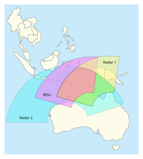
The JORN network is operated by No. 1 Radar Surveillance Unit RAAF (1RSU). Data from the JORN sites is fed to the JORN Coordination Centre at RAAF Base Edinburgh where it is passed on to other agencies and military units. Officially the system allows the Australian Defence Force to observe all air and sea activity north of Australia to distances of 3000 km. This encompasses all of Java, Irian Jaya, Papua New Guinea and the Solomon Islands, and halfway across the Indian Ocean. Other sources put the range at 4000 km from the Australian coastline,[17] as far away as Singapore[18]
The JORN is so sensitive it is able to track planes as small as a Cessna 172 taking off and landing in East Timor 2600 km away. Current research is anticipated to increase its sensitivity by a factor of ten beyond this level. It is also reportedly able to detect stealth aircraft, as typically these are designed only to avoid detection by microwave radar.[4] Project DUNDEE[19] was a cooperative research project, with American missile defence research, into using JORN to detect missiles.[20] The JORN is anticipated to play a role in future Missile Defense Agency initiatives, detecting and tracking missile launches in Asia.[21]
Quote--
Operation and uses[edit]
The JORN network is operated by No. 1 Radar Surveillance Unit RAAF (1RSU). Data from the JORN sites is fed to the JORN Coordination Centre at RAAF Base Edinburgh where it is passed on to other agencies and military units. Officially the system allows the Australian Defence Force to observe all air and sea activity north of Australia to distances of 3000 km. This encompasses all of Java, Irian Jaya, Papua New Guinea and the Solomon Islands, and halfway across the Indian Ocean. Other sources put the range at 4000 km from the Australian coastline,[17] as far away as Singapore[18]
The JORN is so sensitive it is able to track planes as small as a Cessna 172 taking off and landing in East Timor 2600 km away. Current research is anticipated to increase its sensitivity by a factor of ten beyond this level. It is also reportedly able to detect stealth aircraft, as typically these are designed only to avoid detection by microwave radar.[4] Project DUNDEE[19] was a cooperative research project, with American missile defence research, into using JORN to detect missiles.[20] The JORN is anticipated to play a role in future Missile Defense Agency initiatives, detecting and tracking missile launches in Asia.[21]
mostly harmless
OK, I'll try.
If I've understood correctly, the flight lost contact while it was crossing a fairly narrow corridor of airspace that is covered neither by Malaysian nor Vietnamese civil radar. Is this correct? If incorrect, mods, please delete post.
At this point, some catastrophic event is surmised to have occurred that caused all other forms of communication to fail. At the same time, there is as yet no evidence of an explosion, an in-flight collision or any wreckage at this point.
The coincidence that this surmised event happened during the 'radar-blind' corridor crossing is, logically, either relevant or irrelevant.
If relevant, then all sorts of wild theories, such as plane theft, become less implausible. But that nice Mr Occam and his razor tell us to look for simpler theories. The 'civil radar blind corridor' is, presumably, a fairly widely known phenomenon. Who might make use of this corridor? Various militaries, presumably. Is there evidence of illegal / unregistered / unrecorded aviation in the region and at this altitude?
Join Date: Jul 2010
Location: Sydney
Age: 43
Posts: 263
Likes: 0
Received 0 Likes
on
0 Posts
If you go by the Wiki then Jindalee does not have the range to see where this crashed. Of course I expect the operational range is significantly better than indicated on Wikipedia - I guess it comes down to if the RAAF want to give that away. They might just send suggestions to the P-3Cs that are over there helping with SAR.
Jindalee does work very well, but where was it pointing / recording at the time?
And it would be beyond its advertised limit that far north. If they did track it around the Thai border, they won't admit to it.
And it would be beyond its advertised limit that far north. If they did track it around the Thai border, they won't admit to it.

Join Date: Oct 2007
Location: North of Hadrian's Wall
Posts: 116
Likes: 0
Received 0 Likes
on
0 Posts
Reading all of the various reports, I can't help but get the feeling that the Malaysian authorities are covering something up. Is it their air defence set-up's incompetence in failing to observe the unidentified trace heading towards their airspace and crossing the peninsula? Or is it that they did indeed see it but that a panicking command structure had sudden visions of their own 9/11 and the Petronas Towers, and took action that, given the consequences, they would rather not now be made public?
short flights long nights
Re the standby list. They could have been easily sitting a max ZFW with cargo, even if they were not full of passengers. I do flights like that on the triple all the time.
Post 2282:
"We do not know anything about the cause. We only know all comms were gone."
Not a leading question, but do we know the comms were gone? Or can we only say they / it stopped communicating?
"We do not know anything about the cause. We only know all comms were gone."
Not a leading question, but do we know the comms were gone? Or can we only say they / it stopped communicating?
I've passed on a request to Air Force HQ to look at their Jindalee data..and if they can't disclose anything to at least tell their own P3 crew where to look.
They will most likely ignore my request anyway.
I had to ask.
They will most likely ignore my request anyway.
I had to ask.
Join Date: Jul 2008
Location: Sydney
Posts: 2
Likes: 0
Received 0 Likes
on
0 Posts
Car Nicobar airport only 500 miles NW of Penang
Car Nicobar airport is only 500 miles NW of Penang, another 300 miles further NW from where Malaysian radar lost the trace of the unconfirmed object.
Here's how the Indian Express of 23 February reported the Indian Home Ministry's assessment of the Nicobar islands ....
Andaman and Nicobar Islands a potential terror hub: Home Ministry | The Indian Express
The island was over-run by a tsunami a few years ago. Is the airport still operational?
Here's how the Indian Express of 23 February reported the Indian Home Ministry's assessment of the Nicobar islands ....
Andaman and Nicobar Islands a potential terror hub: Home Ministry | The Indian Express
The island was over-run by a tsunami a few years ago. Is the airport still operational?
Join Date: May 2004
Location: Netherlands
Posts: 36
Likes: 0
Received 0 Likes
on
0 Posts
In reply to #2283.
Based on meteorology from Mar 1, NOAA Hysplit shows these winds on Mar 7, 17:00 UTC:

http://ready.arl.noaa.gov/hypubout/11641_trj001.gif
The star is the point of lost radar contact at 17:22Z. (Model time used is 17:00Z.)
The red triangle shows the position of a floating (not falling) object at FL350 (10,668 m) at 18:00Z.
The blue square shows the position of a floating (not falling) object at FL230 (7,000 m) at 18:00Z.
The green circle shows the position of a floating (not falling) object at FL164 (5,000 m) at 18:00Z.
According to this model, the wind at FL350 was about 085 deg at 10 kn. Wind at FL164 was about 100 deg at 20 kn.
Based on meteorology from Mar 1, NOAA Hysplit shows these winds on Mar 7, 17:00 UTC:
http://ready.arl.noaa.gov/hypubout/11641_trj001.gif
The star is the point of lost radar contact at 17:22Z. (Model time used is 17:00Z.)
The red triangle shows the position of a floating (not falling) object at FL350 (10,668 m) at 18:00Z.
The blue square shows the position of a floating (not falling) object at FL230 (7,000 m) at 18:00Z.
The green circle shows the position of a floating (not falling) object at FL164 (5,000 m) at 18:00Z.
According to this model, the wind at FL350 was about 085 deg at 10 kn. Wind at FL164 was about 100 deg at 20 kn.
Last edited by Aireps; 12th Mar 2014 at 13:46.
Join Date: Mar 2014
Location: london england
Age: 66
Posts: 15
Likes: 0
Received 0 Likes
on
0 Posts
Fliegenmong - we can argue semantics but I am happy to say she has been cabin crew on 777s for ten years most recently on Qantas. If you said she was just a passenger she would be very cross indeed. She regards herself as very experienced and highly trained. I only relay her comments, where do you know that she is wrong? I will refer back.
Join Date: Mar 2009
Location: Perth Western Australia
Age: 57
Posts: 808
Likes: 0
Received 0 Likes
on
0 Posts
I've passed on a request to Air Force HQ to look at their Jindalee data..and if they can't disclose anything to at least tell their own P3 crew where to look.
Join Date: Dec 2006
Location: Florida and wherever my laptop is
Posts: 1,350
Likes: 0
Received 0 Likes
on
0 Posts
Is there anybody un this forum who can shed some light on how modern radar equipment works? On the old fashoned CRT design you could simply adjust brightness to get rid of all the noise on the screen (birds etc.). How is sensitivity adjusted today? How is information filtered (i.e. are single returns filtered automatically by the software, because they are obviously noise, and are only repetitatve returns moving within a certain reasonable speed range shown)?
What exactly is recorded? Raw data? Displayed Data? Analyzed, filtered Data? Can we (the civilians...) run special analysis software on that data to scan through it for interesting details?
What exactly is recorded? Raw data? Displayed Data? Analyzed, filtered Data? Can we (the civilians...) run special analysis software on that data to scan through it for interesting details?
The tracks are correlated with the known flight data of the aircraft so that the controller can access flight data by clicking on the position symbol, but also the flight data can be used by the tracker to 'expect' when aircraft will turn. If the aircraft is tracked and late the surveillance processing can update the flight data processing so that times remain correct. The system can also alert when aircraft deviate from cleared levels etc.
What the controller sees is entirely synthetic and the controller has no control over gain etc. It is not normal for an ATC controller to use primary radar only indeed many will switch it off to reduce clutter. However, once an aircraft is being tracked the primary response is 'correlated' with the other track data, so that if the aircraft transponders cease for some reason the labeled display will continue with just the primary response if there is one. If all surveillance sensor data for a track is lost the systems may coast the position symbol for a period along the projected ground track sometimes modified by flight plan track data. This is actually quite common in oceanic areas where position reports may be only every 10 minutes on ADS=C. (Coasting can be seen on systems like Flight Aware.)
Data is recorded at almost every point in the process with greatly differing accessibility. The recordings at the radar heads will be mainly for maintenance purposes not normally for investigation. Once information comes into a center it is recorded again mainly for maintenance and fault finding. All data delivered to controllers for their use is recorded and stored in accordance with ICAO rules which is normally 28 days or more. Most centers will have almost immediate playback capabilities for incident resolution.
Join Date: Jul 2013
Location: Maryland USA
Posts: 133
Likes: 0
Received 0 Likes
on
0 Posts
Jindalee "official range". Apparently it can do much better. It just might have been able to see this event. Someone would have had to have it on and recording though.
From our Wiki Friends
allowing it to have both long range as well as anti-stealth capabilities. It has an official range of 3,000 kilometres (1,900 mi) but in 1997 the prototype was able to detect missile launches by China[6] over 5,500 kilometres (3,400 mi) away.
Jindalee uses 560 kW as compared to the US's OTH-B's 1 MW, yet offers far better range than the US 1980s system, due to the considerably improved electronics and signal processing.[7]

