


Honduras plane crash

Thread Starter
Honduras plane crash
TEGUCIGALPA: At least 10 people were killed on Monday when a small commercial plane with about 20 passengers onboard crashed near the Honduran capital Tegucigalpa, a Red Cross official said.
"There are more than 10 (dead), there are bodies in the cabin of the plane," Red Cross emergency responder Luis Romero told AFP.
The chief of the Honduran Air Force, Colonel Ruiz Pastor Lanza, said the military branch received word that a flight from San Pedro Sula to Tegucigalpa had lost contact with air traffic controllers, and that helicopters and ambulances were dispatched to the region.
Caution: some of the pictures in following link are disturbing
See: Honduras: 14 muertos en accidente a�reo - Pa�s - LaPrensa.hn
Pictures, crew and passenger manifest and report (Spanish).
Last edited by Jetdriver; 15th Feb 2011 at 11:44.

Join Date: Jan 2008
Location: UK
Posts: 1,464
Likes: 0
Received 0 Likes
on
0 Posts
BBC have it now:
BBC News - Honduras vice-minister Robelo among 14 plane crash dead
"Honduras vice-minister Robelo among 14 plane crash dead"
BBC News - Honduras vice-minister Robelo among 14 plane crash dead
"Honduras vice-minister Robelo among 14 plane crash dead"

Join Date: Jul 2003
Location: Manchester
Posts: 891
Likes: 0
Received 0 Likes
on
0 Posts
Join Date: Aug 2005
Location: fl
Posts: 2,525
Likes: 0
Received 0 Likes
on
0 Posts
The TGU R02 approach had to be done accurately or you would hit that hill with an early descent. The DME for the approach when I was flying there in a 757 was deemed unreliable to the south so we used an NDB bearing to start the final step down. I always verified the accuracy of my on board crossing the VOR outbound navigation to back up the NDB bearing knowing what an early descent would cause. We couldn't land straight in but had to circle to land. The minimums were a lower MDA that direction so if we missed the approach from the north we could go lower approaching from the south. TGU is an airport that doesn't give you a whole lot of room for error. I loved it. Landed there hundreds of times.
Join Date: Jun 2009
Location: USA
Posts: 64
Likes: 0
Received 0 Likes
on
0 Posts
The article in Avherald shows the approximate location of the wreck, an approach plate, plus discusses the risks inherent in an early descent.
Crash: Central American Airways L410 near Tegucigalpa on Feb 14th 2011, impacted trees on approach
... a landing vid from the cockpit
YouTube - Cockpit view of a jet landing into Tegucigalpa Honduras TGU
... plus an AA'57 dropping in for a visit
YouTube - Wicked Landing Toncontin Int`l - AA B752
Crash: Central American Airways L410 near Tegucigalpa on Feb 14th 2011, impacted trees on approach
... a landing vid from the cockpit
YouTube - Cockpit view of a jet landing into Tegucigalpa Honduras TGU
... plus an AA'57 dropping in for a visit
YouTube - Wicked Landing Toncontin Int`l - AA B752
Last edited by ST27; 15th Feb 2011 at 15:33.
Join Date: Jun 2007
Location: KIAD east downwind
Posts: 155
Likes: 0
Received 0 Likes
on
0 Posts
aterpster, in this photo, you can see VOR/DME TNT, which is 1.7NM from the threshold. The reports, however, place the crash much farther out at Cerro de Hula � it's the 5660' peak about 7NM out and before abeam the start of the final step-down.
Last edited by dvv; 15th Feb 2011 at 20:46. Reason: typo
Guest
Join Date: Apr 2009
Location: On the Beach
Posts: 3,336
Likes: 0
Received 0 Likes
on
0 Posts
dvv:
If the posting showing the crash site is correct, then it would seem to be a failure (for reasons unkown) to level off at MDA coming out of the procedure turn. The photo, nonetheless, shows how challenging this airport is.
aterpster, in this photo, you can see VOD/DME TNT, which is 1.7NM from the threshold. The reports, however, place the crash much farther out at Cerro de Hula � it's the 5660' peak about 7NM out and before abeam the start of the final step-down.
Join Date: Aug 2005
Location: fl
Posts: 2,525
Likes: 0
Received 0 Likes
on
0 Posts
My friend who managed our ops in TGU said the airport winds were 360@12 knots but the winds at the crash site were over 40 knots. That would produce a significant down draft on the south side of the hills. This may have contributed to going below their step down altitude. The captain was a friend of his.
I have experienced the very strong updraft on the north side turning final but expect the downdraft on the south side would be about the same. Maybe now they have the 02 VOR DME approach approved again but when I retired we needed the NDB bearing for final step down.
I have experienced the very strong updraft on the north side turning final but expect the downdraft on the south side would be about the same. Maybe now they have the 02 VOR DME approach approved again but when I retired we needed the NDB bearing for final step down.
Guest
Join Date: Apr 2009
Location: On the Beach
Posts: 3,336
Likes: 0
Received 0 Likes
on
0 Posts
bubbers44:
They also now have RNP AR approaches to both runways for those who can do those. The RNP AR to Runway 20 is pretty good, but the one to Runway 2 is what I would call an RNP to visual conditions; not exactly what RNP AR is supposed to do.
I have experienced the very strong updraft on the north side turning final but expect the downdraft on the south side would be about the same. Maybe now they have the 02 VOR DME approach approved again but when I retired we needed the NDB bearing for final step down.
Join Date: Aug 2005
Location: fl
Posts: 2,525
Likes: 0
Received 0 Likes
on
0 Posts
I agree. Continental and us usually arrived at TGU within minutes of each other so this day it was VMC and continental was directly below us 1,000 ft so we were following them in as #2 to land. They decided, probably for training, to do the RNP arrival so we had to hover over them for several minutes for their 3+ mile excursion to the west for a long left base. We could have landed and parked by the time they landed on 02. I told our manager who was testing that approach for us what a waste of money and training it was for us to do the same thing. I told him I have landed here over 500 times and only one time had to divert. No airliner landed that day because of low ceilings. We didn't change our approaches and probably saved 100s of thousands of dollars. 90% of the landings are on 02 because of the prevailing wind and as you said the RNP approach doesn't help on 02.
I guess I took us off topic, sorry, but I don't think an RNP procedure would have helped them make a safer approach because even though they were doing the 20 approach, because of the north wind, they would have had to circle to 02.
I guess I took us off topic, sorry, but I don't think an RNP procedure would have helped them make a safer approach because even though they were doing the 20 approach, because of the north wind, they would have had to circle to 02.
Join Date: Aug 2005
Location: fl
Posts: 2,525
Likes: 0
Received 0 Likes
on
0 Posts
The hill in question was several miles south of the picture. Properly flown this, in my opinion, is a safe airport. Just fly the approach. Any approach, improperly flown, can end up in disaster. Any landing, disregarding tailwind, wet runway can be a disaster. How many landing accidents at TGU were not caused by pilot error. Probably none. You have to know what you are doing to land there. You don't have to be an ace, just do it right. TGU was my favorite because it was challenging, but safe. The people were great and the passengers always clapped when you came to a stop without killing anybody. Never happened in Miami.
Join Date: Feb 2006
Location: USA
Posts: 487
Likes: 0
Received 0 Likes
on
0 Posts
bubbers44:
Can't quite reconcile your two posts:
Isn't it far more likely they were flying the VOR DME Rwy 02 procedure?
Can't quite reconcile your two posts:
...even though they were doing the 20 approach, because of the north wind, they would have had to circle to 02....
...hill in question was several miles south of the picture.
Join Date: Aug 2005
Location: fl
Posts: 2,525
Likes: 0
Received 0 Likes
on
0 Posts
Yes, they were doing the VOR DME 02 approach. I was referring to the post saying the RNP 02 approach doesn't do more than set you up for a visual into the valley but the RNP 20 approach lines you up with 20 and with any significant north wind they would have to circle.
Join Date: Jan 2002
Location: MIA
Posts: 11
Likes: 0
Received 0 Likes
on
0 Posts
I can't find any RNAV approaches to MHTG on my computer but would like to see what their minimums are. We never approved these approaches so we have no access to them. If you Continental guys that have it would post it, I would appreciate it. As I said, I had no problem with the basic approach getting in so want to see the advantage of the RNAV approach. Thanks.
We landed there one day when we were an hour late and Continental had diverted to SAP. We filled up our extra seats with their stranded passengers so walked over to their ops and said why are'nt you landing,look at the sky? Their captain said they must have landed below minimums. He finally took off and came back to pick up the passengers who couldn't get on our flight. We had blue skies when we took off. Yes, we liked getting their passengers, but felt sorry for the ones we left for no reason since the captain must have been using old wx data. More than likely it was the best wx he could get in Honduras.
I tried to get over to say hi to their pilots when I could. They were good guys and liked a bit of adventure. PMing would be fine if you prefer.
Join Date: Jun 2007
Location: KIAD east downwind
Posts: 155
Likes: 0
Received 0 Likes
on
0 Posts
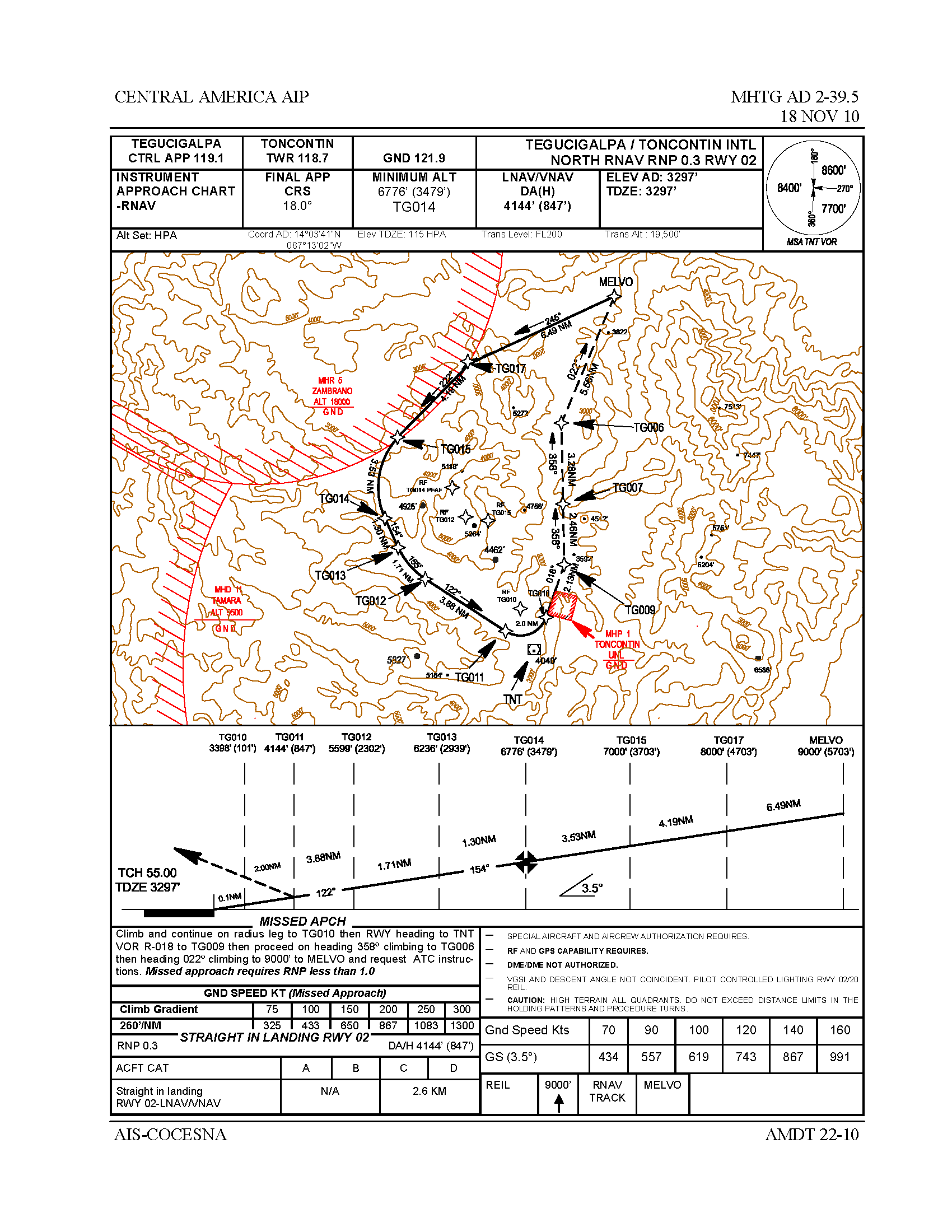
Last edited by dvv; 17th Feb 2011 at 16:10. Reason: graphics added
Join Date: Aug 2005
Location: fl
Posts: 2,525
Likes: 0
Received 0 Likes
on
0 Posts
Thanks dvv, I have never seen the RNAV 02 approach so had no idea they could go to 850 ft AFL at MAP. We had to have 2700 ft AFL for the VOR 20 approach. Looking at it I am glad we never got certified for it. We didn't get GPS until my last couple of years before retirement but losing systems on that base leg with mountains on both sides would be very interesting. I now stand corrected and the RNAV 02 from the north would have prevented this accident. I still can't believe they approved this approach to those low minimums with mountains all around them and that close. Can you skin that close to mountains on an ILS? I didn't think so but never having done a GPS RNAV approach have no knowledge of the rules so I will shut up.
Guest
Join Date: Apr 2009
Location: On the Beach
Posts: 3,336
Likes: 0
Received 0 Likes
on
0 Posts
bubbers44:
This is not an ordinary GPS approach. It is an RNP Authorization Required approach. (RNP AR). Whenever an RNP AR approach requires less than RNP 0.30 or the missed approach requires RNP of less than 1.0, then the position has to be backed up by at least one IRU for additional FMS position. Thus, if the GPS fails, the IRU or IRUs (usually three) will provide sufficient position accuracy to complete the missed approach procedure.
We didn't get GPS until my last couple of years before retirement but losing systems on that base leg with mountains on both sides would be very interesting. I now stand corrected and the RNAV 02 from the north would have prevented this accident. I still can't believe they approved this approach to those low minimums with mountains all around them and that close. Can you skin that close to mountains on an ILS? I didn't think so but never having done a GPS RNAV approach have no knowledge of the rules so I will shut up.