


Ash clouds threaten air traffic

From the NATS website:
Statement on Icelandic volcanic eruption: Friday April 16, 2045
The volcanic ash cloud continues to affect UK airspace. Following the latest update from the Met Office, NATS advises that the restrictions currently in place across UK controlled airspace will remain in place until at least 1300 (UK time) on Saturday April 17.
There are currently no airspace restrictions in Scotland, Northern Ireland and in an area over the North Sea that includes the Shetlands and Orkney Isles. Manchester, Liverpool and all airports North of those may be available from 0400 (UK time) � 1000 (UK time) for departures to and arrivals from the North and West subject to individual co-ordination. However, please be advised that the situation is continuously changing. Forecasts indicate that the ash cloud is expected to return over Northern England at 1000 (UK time) and it is likely that restrictions will be reintroduced.
Please note these arrangements do not mean that all flights will operate. Anyone hoping to travel today or tomorrow should contact their airline before going to the airport.
We are looking for opportunities when the ash cloud moves sufficiently for us to enable some flights to operate under individual coordination with ATC.
We will review further Met Office information and at 0900 (UK time) on Saturday we will advise further arrangements.
We continue to work closely with airports, airlines, and the rest of Europe to understand and mitigate the implications of the volcanic eruption.

Join Date: Jul 2004
Location: Duh...
Posts: 12
Likes: 0
Received 0 Likes
on
0 Posts
Restrictions extended till 1300 Sat. Our company are telling us that NATS are using a computer model based on a Canadian eruption from the past. This eruption had different ash densities to the current Icelandic one. Upshot is they are pressurising NATS to rethink the model. Personally I don't rate their chances.
Join Date: Dec 2008
Location: North of England
Posts: 119
Likes: 0
Received 0 Likes
on
0 Posts

Join Date: Aug 2006
Location: Cyprus
Posts: 9
Likes: 0
Received 0 Likes
on
0 Posts
Join Date: Jul 2009
Location: Texas, USA
Age: 70
Posts: 13
Likes: 0
Received 0 Likes
on
0 Posts
Is the Ash Cloud radar reflective? And if so, at what radar frequencies? (cm, mm, etc)
P.S. Anyone know what the Carbon Footprint of the Volcano is? How will Iceland offset its emissions?
Join Date: Jan 2008
Location: uk
Posts: 4
Likes: 0
Received 0 Likes
on
0 Posts
etherate
I thought the earlier post with the satellite image of the actual plume was telling. Surely with modern technology of satellite imagery, the airspace closure could be narrowed down significantly to just the areas closest to the plume for avoidance? One wonders if we might be slightly over-reacting just a tad.
As I recall in Eric Moody's encounter (based on the chapter "Strange Encounter" in the book "Emergency") the BA009 flew very close to the volcanic ash cloud and not 700 miles away from the eruption as is most of UK airspace.
With the significantly dispersed cloud tracking over the UK there must be a much lower risk of contamination.
One problem is nobody seems to have any data as to acceptable or permitted levels of ash concentration affecting jet engines.
The other big problem, it now seems to me; is that someone is going to have to make a very difficult decision as to when to re-commence operations against an extremely hard to gauge risk of engine failure caused by volcanic ash penetration. I don't envy those who are going to have to take that one !
Join Date: Apr 2008
Location: .
Posts: 309
Likes: 0
Received 0 Likes
on
0 Posts
Is the Ash Cloud radar reflective? And if so, at what radar frequencies? (cm, mm, etc)
This is quite an interesting read on the subject:
http://www.ece.mtu.edu/faculty/wfp/articles/diel8.pdf
The best way to detect the ash is with lidar rather than radar, though. Only one is operational now, but there's currently a proposal to reactivate a few space based lidars for north sea/iceland overpasses. Not an easy job though and by the time the beauracracy has percolated it'll probably be too late.
Or for a/c to avoid ash concentrations themselves (like routeing around CBs for example).
I'm also not sure how an aircraft radar would deal with volcanic ash. It behaves differently to rain, etc, so there's a chance that much of the information could be filtered out in software before it even reached the cockpit. I don't know enough to comment further on that though.
P.S. Anyone know what the Carbon Footprint of the Volcano is? How will Iceland offset its emissions?

Not sulpher negative though, and I have no idea how this affects the weather...ash is a rather good absorber of sunlight.
(edit)
Surely with modern technology of satellite imagery, the airspace closure could be narrowed down significantly to just the areas closest to the plume for avoidance?
As of an hour ago Iceland is more or less clear by the looks of things.
Join Date: Dec 2008
Location: North of England
Posts: 119
Likes: 0
Received 0 Likes
on
0 Posts
Join Date: Sep 2006
Location: Midlands
Posts: 128
Likes: 0
Received 0 Likes
on
0 Posts
BA009 flew very close to the volcanic ash cloud and not 700 miles away from the eruption as is most of UK airspace.
Why do so many people do not just simply grasp the fact it's there even if yoou can't see it?
Join Date: Apr 2008
Location: .
Posts: 309
Likes: 0
Received 0 Likes
on
0 Posts
But surely the particulates are bigger than water droplets (or at least no smaller), and surely more radar reflective?
Join Date: Nov 2003
Location: At home
Posts: 26
Likes: 0
Received 0 Likes
on
0 Posts
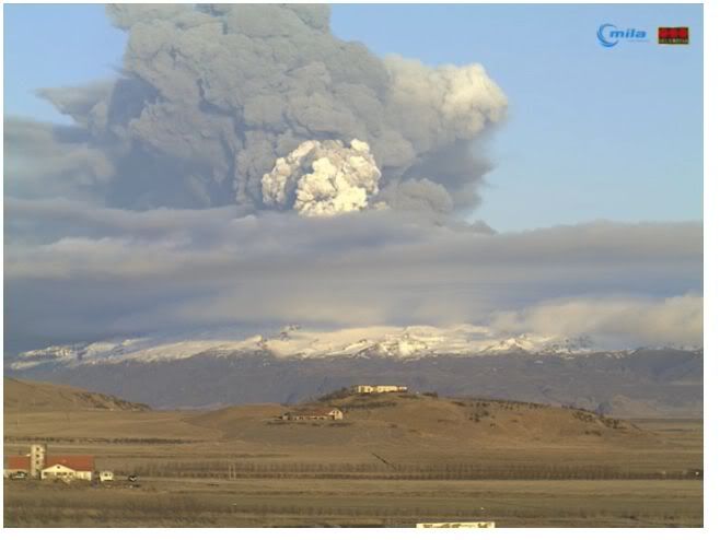
For those interested, to draw your own conclusions on wether the no fly zone by Eurocontrol is waranted or not. To give some perspective Mt Eyjafjallaj�kull is 1666m/5465,8 ft.
This camera is located aprox 35km west of the mountain
http://http://eldgos.mila.is/eyjafja...thorolfsfelli/
This camera is located aprox 35km west of the mountain
http://http://eldgos.mila.is/eyjafja...thorolfsfelli/
Join Date: Dec 2008
Location: North of England
Posts: 119
Likes: 0
Received 0 Likes
on
0 Posts
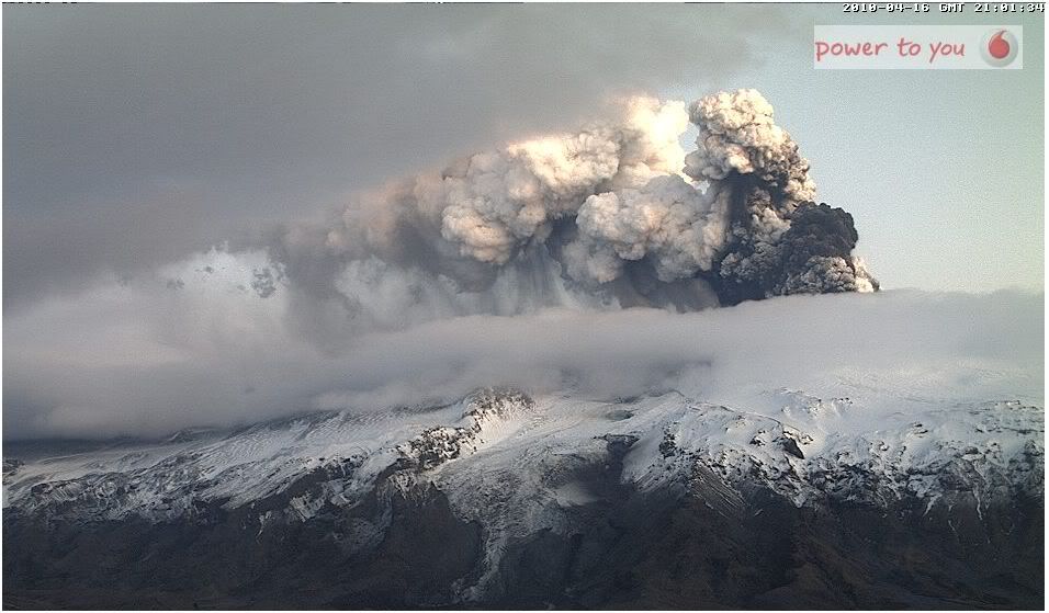
Incredible sight on the webcams at the moment. This is far worse than Tuesday's event. If you can't view the webcams, I'm happy to take screen grabs and post here. Maybe mods are ok with this? I'm sure some won't be able to view the 'cams..

Join Date: Feb 2001
Location: Europe
Posts: 1,109
Likes: 0
Received 0 Likes
on
0 Posts
It looks St.Petersburg and Moscow airports still operating at full capacity even they are shown in the affected area?
And why we don't hear about dozens of crashes there?
And why we don't hear about dozens of crashes there?

Join Date: Dec 2008
Location: North of England
Posts: 119
Likes: 0
Received 0 Likes
on
0 Posts
GfaRm
Are you saying this clock is wrong?
http://i904.photobucket.com/albums/a.../current13.jpg
Top right.
Btw, it's getting dark now
Vodafone.is - Eruption in Iceland 2010
Look at the time - 30 mins later
Are you saying this clock is wrong?
http://i904.photobucket.com/albums/a.../current13.jpg
Top right.
Btw, it's getting dark now
Vodafone.is - Eruption in Iceland 2010
Look at the time - 30 mins later
Join Date: Jan 2008
Location: Denmark
Age: 79
Posts: 158
Likes: 0
Received 0 Likes
on
0 Posts
sunrise/sunset in Iceland (Reykjavik).
For info: sunrise/sunset
16 Apr 2010 05:53 21:04
20 Jun 2010 02:55 00:04
22 Dec 2010 11:23 15:30
Position for Reykjavik is 64�08′N 21�56′W
Local time: UTC
16 Apr 2010 05:53 21:04
20 Jun 2010 02:55 00:04
22 Dec 2010 11:23 15:30
Position for Reykjavik is 64�08′N 21�56′W
Local time: UTC