


Kobe Bryant killed in S76 crash

Join Date: Sep 2017
Location: Bremen
Posts: 118
Likes: 0
Received 0 Likes
on
0 Posts
I was happy to learn that 135.293 (c) requires VFR-only helicopter pilots to demonstrate each year that they can safely return to VMC from inadvertant IMC.

Join Date: Sep 2017
Location: Bremen
Posts: 118
Likes: 0
Received 0 Likes
on
0 Posts
Got my hands on the FULL ADS-B file which is 2 data frames per second as opposed to the one frame every five seconds that's been going around. Working on a .KML file for google earth. Looks to be a controlled left turn right over that address, until the last few data frames. Here's a link to an image host since I don't have 10 posts-
imgurDOTcom/a/KNsDRPu (replace 'DOT' with . )
imgurDOTcom/a/KNsDRPu (replace 'DOT' with . )
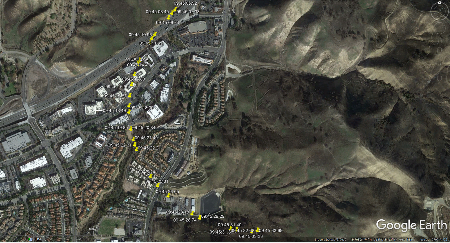
created by 377 Pete
This does look like the turn is too early for following the overpass by mistake.
I couldn't tell by the picture if this was a controlled turn or a graveyard spiral, but the very quick descent from 2300ft altitude is unlikely to be intentional.
Is the KML file at the bottom of the FR24 blog page not based on the "granular" ADS-B data?
Join Date: May 2011
Location: Kiev
Posts: 2
Likes: 0
Received 0 Likes
on
0 Posts
Folks...we can't trust to any ADS-B data from FR24.
For instance it shows around 80 kt everytime we are on the ground after landing.
Our today's flight: two landings: 10.42 and 11.00, the first landing is displayed with zero ALT and AS 79kt, the second- 1500 ft with 80 kt while on the ground. I should say the elevation of the helipads is almost the same(400 ft).
I could see no any accurate data on the FR24 and even location is wrong.
So it's better to keep that in mind when concluding the the last seconds of the flight discussed.
I don't believe in CFIT as well as the Pilot flew up to 130 kt between cloud layers with low visibility in mountain area.
The AP wasn't coupled for sure and he made left 180 by hand on final phase.
Looks like loss of airspeed control while climbing through the clouds.
Zero speed... POB 09... Heavy aircraft...VRS...SWP...
Only God knows. RIP.
Last edited by spacetracer; 3rd Feb 2020 at 07:40.
Insider,
What is the difference in sounds made by the various models of the 76? Does a B Model sound any different than an A model or C model?
What is the difference in sounds made by the various models of the 76? Does a B Model sound any different than an A model or C model?
It doesn't sound different enough to be able to make a reasoned judgement from someone's door bell cam recording but there is no way it is at 160 knots and 90 degrees of bank or spinning.
Many people seem to be dissecting this accident too forensically and putting forward wild theories. Statistically, while there maybe subtle nuances, the underlying cause has sadly been seen before.
there is no way it is at 160 knots and 90 degrees of bank or spinning
Join Date: Sep 2017
Location: Bremen
Posts: 118
Likes: 0
Received 0 Likes
on
0 Posts
Folks...we can't trust to any ADS-B data from FR24.
For instance it shows around 80 kt everytime we are on the ground after landing.
Our today's flight: two landings: 10.42 and 11.00, the first landing is displayed with zero ALT and AS 79kt, the second- 1500 ft with 80 kt while on the ground. I should say the elevation of the helipads is almost the same(400 ft).
I could see no any accurate data on the FR24 and even location is wrong.
So it's better to keep that in mind when concluding the the last seconds of the flight discussed.
To be logged by FR24, an ADS-B transmission has to be received by one of its receivers, and their coverage is not complete (and it also appears that messages drop out more in high-traffic areas). So if the last transmision FR24 receives from you is during your approach at 1500ft and 80 kts before your craft gets too low and loses radio contact, that is what it will display, because that is all it has. For the FR24 realtime tracking, there may also be programming that guesses where aircraft are when reception drops out intermittently; I expect that observed "impossible" flight maneouvres result from "bad guesses" during dropouts. And aircraft themselves are supposed to "guess" their positions between GPS updates when sending out ADS-B data.
In this case, we are looking at a completed flight, and (presumably) the exact ADS-B data as it was received from the aircraft; and here also, we know that we don't have complete coverage because the final few hundred feet down to impact altitude are missing from the data.
(I have also seen a study that suggests some ADS-B systems have hardware or software issues that could cause small errors in the data. It's always a good idea to cross-check if the data make sense.)
Join Date: May 2011
Location: Kiev
Posts: 2
Likes: 0
Received 0 Likes
on
0 Posts
To be logged by FR24, an ADS-B transmission has to be received by one of its receivers, and their coverage is not complete (and it also appears that messages drop out more in high-traffic areas). So if the last transmision FR24 receives from you is during your approach at 1500ft and 80 kts before your craft gets too low and loses radio contact, that is what it will display, because that is all it has. For the FR24 realtime tracking, there may also be programming that guesses where aircraft are when reception drops out intermittently;
C130 down NE Cooma
Interesting explanation of online ADS-B data and how it can be accurately analyzed. I cannot vouch for the veracity of this explanation.
Interesting explanation of online ADS-B data and how it can be accurately analyzed. I cannot vouch for the veracity of this explanation.
it's totally inaccurate for the whole flight from take off until landing
Join Date: Jul 2014
Location: Germany
Posts: 344
Likes: 0
Received 0 Likes
on
0 Posts
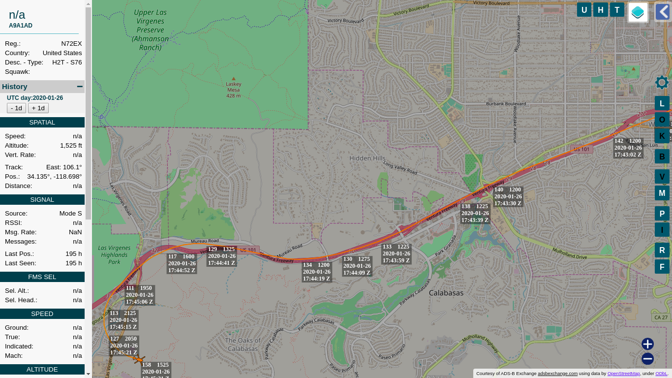
Some ADS-B data points:
https://tar1090.adsbexchange.com/?ic...-01-26&zoom=15
Press K for labels. The labels show ground speed, uncorrected barometric altitude and a timestamp.
Add 225 ft to get the approximate altitude above mean sea level. (250 ft might be more accurate but that's more theoretical)
Attached a KML file with the altitudes corrected by 225 ft and converted to meter as per KML standard.
You'll have to remove the .doc ending, the forum didn't want a KML file.
The KML file can be viewed for example on http://earth.google.com/
The screenshot from the FR24 data a couple of posts before has more points, still thought i'd post a different data source for those curious.
If one guy is saying his aircraft data is inaccurate and others are saying the system is accurate but relies upon the aircraft system being accurate.....how do we know the particular aircraft is sending accurate data?
How do you check your own aircraft to confirm it is operating correctly?
Has that been done?
How do you check your own aircraft to confirm it is operating correctly?
Has that been done?
How do you check your own aircraft to confirm it is operating correctly?
Also when you install ADS-B, at least in the US, you are required to conduct a test flight to confirm correct operation.
For VFR flight, FR24 relies on ADS-B. Now that means everything flying, round here anyway, but until recently it generally didn't show small planes.
If one guy is saying his aircraft data is inaccurate and others are saying the system is accurate but relies upon the aircraft system being accurate.....how do we know the particular aircraft is sending accurate data?
How do you check your own aircraft to confirm it is operating correctly?
Has that been done?
How do you check your own aircraft to confirm it is operating correctly?
Has that been done?
Just because your phone says it was so, does not make it so.
If ATC can't get accurate data with SSR or ground stations, then it's not worthy as a basis for a fictional opinion.
So....I take all this jibber jabber about location, speed, etc....is just that.
Until we know if all those checks, flight tests, equipment installs were done and passed all the requirements....all this is just so much talk and arm waving amounts to some interesting entertainment but has no probative value.
Or....do I miss something?
Until we know if all those checks, flight tests, equipment installs were done and passed all the requirements....all this is just so much talk and arm waving amounts to some interesting entertainment but has no probative value.
Or....do I miss something?
If one guy is saying his aircraft data is inaccurate and others are saying the system is accurate but relies upon the aircraft system being accurate.....how do we know the particular aircraft is sending accurate data?
How do you check your own aircraft to confirm it is operating correctly?
Has that been done?
How do you check your own aircraft to confirm it is operating correctly?
Has that been done?
The FAA provides a free, web-based service called the Public ADS-B Performance Report (PAPR) at https://adsbperformance.faa.gov/PAPRRequest.aspx. Additional information on the PAPR service can be found at https://www.faa.gov/nextgen/equipadsb/. The FAA recommends that owner/operators of ADS-B Out-equipped aircraft verify equipment performance through periodic use of the PAPR request service.
Per � 91.227 Automatic Dependent Surveillance-Broadcast (ADS-B) Out equipment performance requirements, ADS-B Out Performance Requirements for Navigation Accuracy Category for Position (NACP) specifies the accuracy of a reported aircraft's position, as defined in TSO-C166b and TSO-C154c:
(1) For aircraft broadcasting ADS-B Out as required under 91.225 (a) and (b) -
(i) The aircraft’s NACP must be less than 0.05 nautical miles;
(ii) The aircraft’s NACV must be less than 10 meters per second;
Source: AC No: 90-114B Automatic Dependent Surveillance-Broadcast Operations (12/30/2019)
Last edited by JimEli; 3rd Feb 2020 at 18:35. Reason: added source
If one guy is saying his aircraft data is inaccurate and others are saying the system is accurate but relies upon the aircraft system being accurate.....how do we know the particular aircraft is sending accurate data?
How do you check your own aircraft to confirm it is operating correctly?
Has that been done?
How do you check your own aircraft to confirm it is operating correctly?
Has that been done?
The first thing in use was separate SDR receiver and software monitoring.
Started static on apron, later during mag sensor calibration on ground taxi and finally flying within airport circle.
On apron we find out that navigator from producer A is not feeding transponder from producer B with Alt data, position data was in in order - even much better than expected EGNOS level 7,5m on all three axis.
Therefore we was forced to provide extra serial RS232 source with Alt data.
After that we included "new" object on FR24 network.
Just remember that you need attenuator if front, because most of SDR-s are not able to receive correct data
in case of over-driven input.
interesting entertainment but has no probative value
But as far as the ADS-B / FR24 data is concerned, some common sense applies. The data is mostly self consistent and consistent with other known facts. There are a few apparent anomalies especially with heading and altitude, but they are obvious (and in the case of heading, could have been caused by the way it was flying in the last few seconds). It's extremely improbable that the smooth curve shown on the most recent plot would happen by chance.
Also, the aircraft was equipped for flight in the LAX Class B veil (and was within it until a minute or so before the crash), i.e. it was required to have a certified ADS-B installation. So yes, "all those checks, flight tests, equipment installs were done and passed all the requirements" were required to have been done. It COULD have been done by a rogue avionics shop, and not have been flight tested, but it doesn't seem very likely.
Join Date: Jul 2014
Location: Germany
Posts: 344
Likes: 0
Received 0 Likes
on
0 Posts
In regards to data accuracy: The GPS isn't off, otherwise the track wouldn't be following the US101 so nicely.
And it is indeed not fact or probative value, but it's by a long shot the best data available.
I'd see it as more reliable than an eye witness.
The data also fits exceptionally well with the crash location, so there aren't any red flags in regards to the data that would make them unbelievable.
And it is indeed not fact or probative value, but it's by a long shot the best data available.
I'd see it as more reliable than an eye witness.
The data also fits exceptionally well with the crash location, so there aren't any red flags in regards to the data that would make them unbelievable.
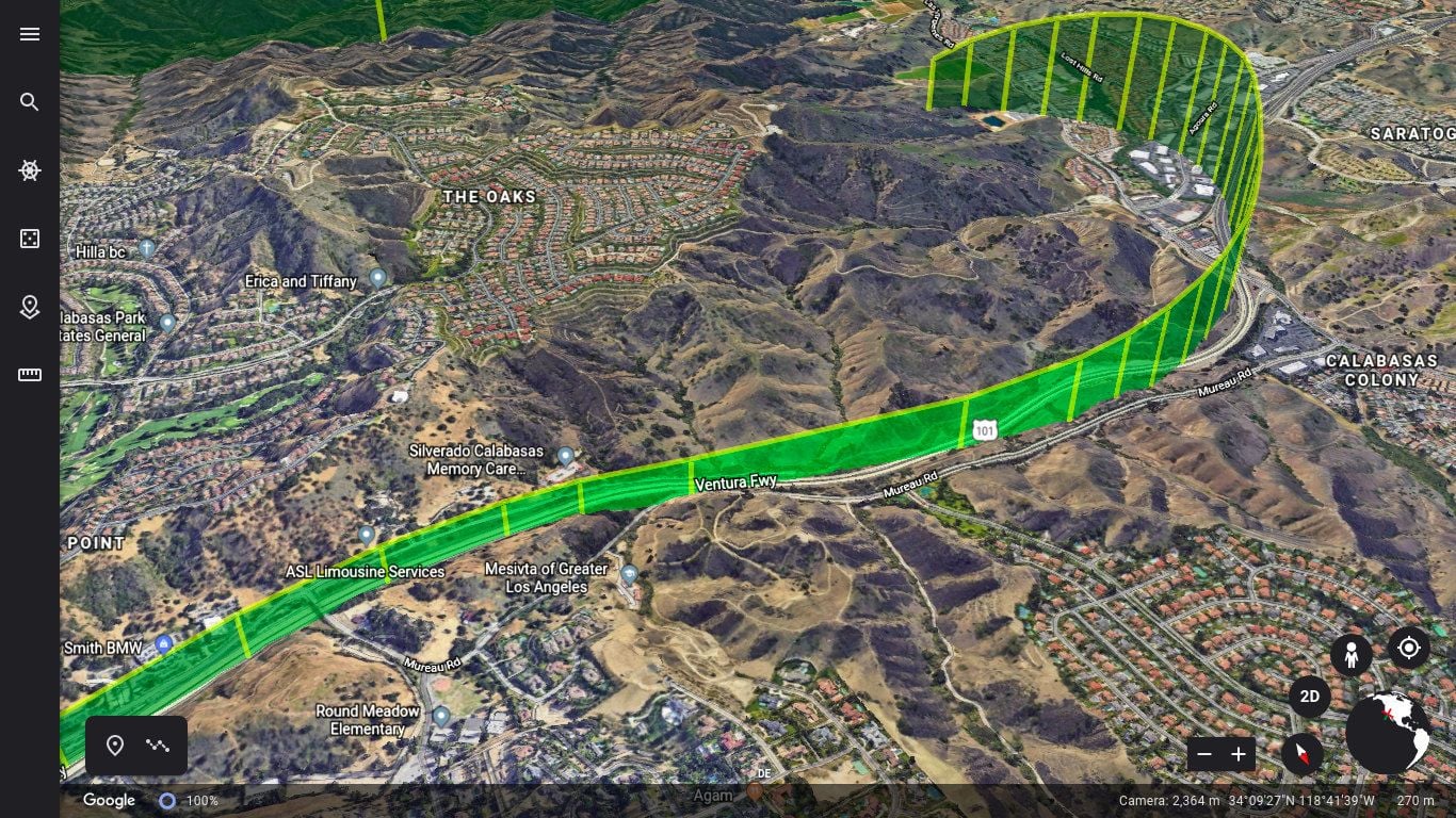
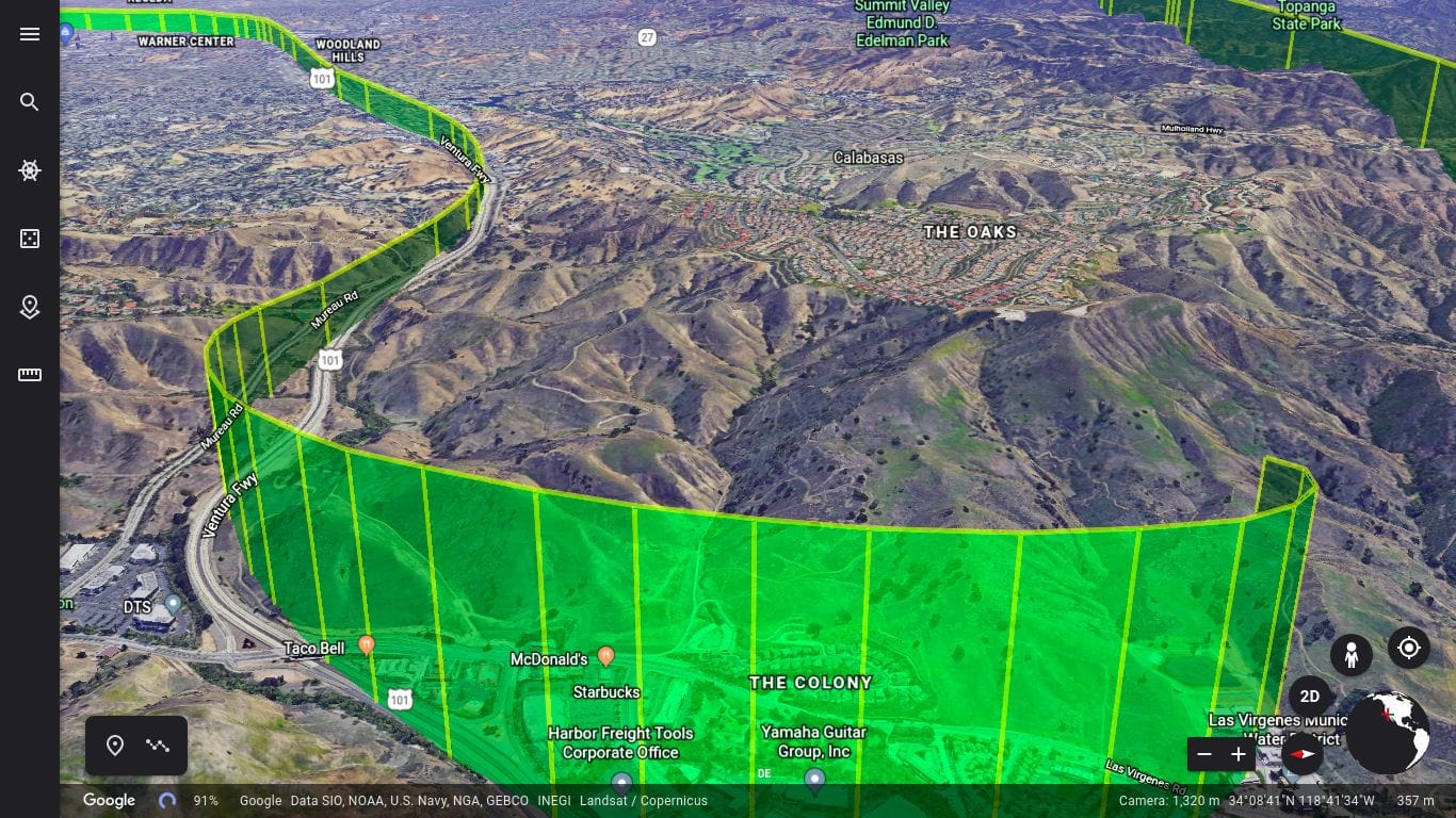
For wiedehopf
While that's a nice reconstruction, it isn't the same as a trace from FDR data.
Which I suspect is a point that SASless is hinting at.
What was going on in the last 10-15 seconds inside the cockpit isn't told in that reconstruction. That - what was happening inside the cockpit - is the key to learning anything of value from this loss of lives and loss of a helicopter.
All that the reconstruction does is show the route to the scene of the crash site.
Join Date: Jul 2014
Location: Germany
Posts: 344
Likes: 0
Received 0 Likes
on
0 Posts
I'm perfectly aware and i don't think i drew any conclusions.
There is no CVR or FDR for that particular helicopter if i'm not mistaken.
Edit:
Removed unnecessary speculation.
There is no CVR or FDR for that particular helicopter if i'm not mistaken.
Edit:
Removed unnecessary speculation.
Last edited by wiedehopf; 4th Feb 2020 at 00:04.