


Kobe Bryant killed in S76 crash

Folks.....now is not the time to be posted names of those lost in this tragedy.
How about showing some courtesy and deleting your posts until the family and friends have time to learn of the loss of their family and friends through official means.
How about showing some courtesy and deleting your posts until the family and friends have time to learn of the loss of their family and friends through official means.

Join Date: Nov 2007
Location: Massachusetts
Age: 67
Posts: 172
Likes: 0
Received 0 Likes
on
0 Posts
There is provision to fly certain types single-pilot IFR because they were certified that way. The Bell 222 comes to mind.
The S-76 was certified two-pilot IFR.
However, even if a helicopter was certified single-pilot IFR you cannot provide a commercial IFR service without two pilots.
The S-76 was certified two-pilot IFR.
However, even if a helicopter was certified single-pilot IFR you cannot provide a commercial IFR service without two pilots.
Again regarding the regs, as pointed out by rotormatic in the US a Part 135 operator can be SPIFR with an autopilot.
Last edited by Paul Cantrell; 27th Jan 2020 at 02:24.
Join Date: Dec 2018
Location: Canada
Posts: 170
Likes: 0
Received 0 Likes
on
0 Posts
Join Date: Jun 2001
Location: Rockytop, Tennessee, USA
Posts: 5,898
Likes: 0
Received 1 Like
on
1 Post
From the FAA TCDS
NOTE 15: 1-pilot IFR is approved for Models S-76A, S-76B, S-76C, and S-76D when appropriately equipped and operating in accordance with a flight manual or flight manual supplement that allows such operation. For Models S-76A, S-76B, and S-76C, 1-pilot IFR operation requirements include installation of an SPZ-7000 Digital Automatic Flight Control System by STC or an SPZ-7600 Digital Automatic Flight Control System by STC or as optional equipment. The following Honeywell Flight Manual Supplements relate to 1-pilot IFR operations with the SPZ-7000:
So the aircraft could have been IFR, depending on the equipment
Operations as noted above
HTAWS is required under HAA, 135 Subpart L Helicopter Air Ambulance Equipment, Operations, and Training Requirements
Join Date: Jul 2013
Location: USA
Posts: 6
Likes: 0
Received 0 Likes
on
0 Posts
I'm a fixed wing pilot. First some data, then some questions for the helo pilots here...
METARs and PIREPs around the time of the crash show the marine layer bases were around 1500' and tops around 2500', with marginal visibility:
According to the USGS Topo maps I have of the area, the highway elevation along the 101 tops out around 1100' just to the east of Las Virgines Rd, with hills up to 2000' to the north and south. Approaching Las Virgines, the highway dips into a valley and is at about 760' elevation. Two private helipads in the area are charted at 850' and 888'. Further west, the highway rises back to around 900' before descending through the Conejo Grade towards Camarillo.
Tracks posted upthread show N72EX was following US-101, at an altitude around 1200'. This suggests they were flying in hazy conditions just below the cloud deck. While the conditions were certainly marginal, they appear to have done just fine following the 101, and had already passed the highest portion of the highway along their route. (The south/east-bound turn started west of Las Virgines)
Assuming the FR24 and FA data are to be believed, N72EX then turned to the south/east, and possibly started a climb before the crash. My questions:
1) Are inadvertent IMC procedures the same for helos as fixed wing - that is, doing a 180? I'd imagine there are more options including trying to slow, hover, or try to set down short of a cloud bank if one sees it looming, or is that not practical?
2) What is the maximum climb capability of the S-76? (i.e. how long to get on top of a 1000' foot cloud layer, if required)
Putting it differently:
3) Are there any circumstances where a helo pilot would choose to turn and climb like that, knowing it would put them into a cloud especially if they weren't already?
METARs and PIREPs around the time of the crash show the marine layer bases were around 1500' and tops around 2500', with marginal visibility:
KBUR 261753Z 00000KT 2 1/2SM HZ OVC011 12/09 A3016 ; KBUR is 778 MSL so suggests bases of 1800' or so.
KVNY 261751Z 00000KT 2 1/2SM HZ OVC013 12/09 A3016 ; KVNY is 802 MSL so suggests bases of 2100'
KCMA 261755Z 03003KT 4SM HZ OVC017 15/11 A3019 ; KCMA is 77 MSL so bases of 1700' or so.
CMA UA /OV 08002/TM 1620/FL012/TP RV8/SK BASES AT 013 TOPS AT 026
SNA UA /OV KSNA180005/TM 1715/FL027/TP B737/SK OVC027-TOP
LGB UA /OV LGB200005/TM 1748/FL022/TP DA42/SK OVC012-TOP022
Tracks posted upthread show N72EX was following US-101, at an altitude around 1200'. This suggests they were flying in hazy conditions just below the cloud deck. While the conditions were certainly marginal, they appear to have done just fine following the 101, and had already passed the highest portion of the highway along their route. (The south/east-bound turn started west of Las Virgines)
Assuming the FR24 and FA data are to be believed, N72EX then turned to the south/east, and possibly started a climb before the crash. My questions:
1) Are inadvertent IMC procedures the same for helos as fixed wing - that is, doing a 180? I'd imagine there are more options including trying to slow, hover, or try to set down short of a cloud bank if one sees it looming, or is that not practical?
2) What is the maximum climb capability of the S-76? (i.e. how long to get on top of a 1000' foot cloud layer, if required)
Putting it differently:
3) Are there any circumstances where a helo pilot would choose to turn and climb like that, knowing it would put them into a cloud especially if they weren't already?
Join Date: Jun 2019
Location: TN
Posts: 44
Likes: 0
Received 0 Likes
on
0 Posts
From the FAA TCDS
NOTE 15: 1-pilot IFR is approved for Models S-76A, S-76B, S-76C, and S-76D when appropriately equipped and operating in accordance with a flight manual or flight manual supplement that allows such operation. For Models S-76A, S-76B, and S-76C, 1-pilot IFR operation requirements include installation of an SPZ-7000 Digital Automatic Flight Control System by STC or an SPZ-7600 Digital Automatic Flight Control System by STC or as optional equipment. The following Honeywell Flight Manual Supplements relate to 1-pilot IFR operations with the SPZ-7000:
So the aircraft could have been IFR, depending on the equipment
Operations as noted above
HTAWS is required under HAA, 135 Subpart L Helicopter Air Ambulance Equipment, Operations, and Training Requirements
NOTE 15: 1-pilot IFR is approved for Models S-76A, S-76B, S-76C, and S-76D when appropriately equipped and operating in accordance with a flight manual or flight manual supplement that allows such operation. For Models S-76A, S-76B, and S-76C, 1-pilot IFR operation requirements include installation of an SPZ-7000 Digital Automatic Flight Control System by STC or an SPZ-7600 Digital Automatic Flight Control System by STC or as optional equipment. The following Honeywell Flight Manual Supplements relate to 1-pilot IFR operations with the SPZ-7000:
So the aircraft could have been IFR, depending on the equipment
Operations as noted above
HTAWS is required under HAA, 135 Subpart L Helicopter Air Ambulance Equipment, Operations, and Training Requirements
From Sir Korsky:
have you ever flown a B with a corporate interior? I thought not.
have you ever flown a B with a corporate interior? I thought not.
Yes I operated the only B in the country (at the time), kitted for VVIP, one row of seats removed for extra space, for 6 years. Magnificent machine, dual digital everything, single pilot IFR, TCAS, satphone, the lot.
No unfixable cg problems at any time or load, even with heavies like Tom Cruise or Prince Harry on board, along with their hordes of minders. Judicious use of the cargo compartment and less fuel kept the front-heavy bird in limits.
For this run, my Excel spreadsheet shows 2 in the front, 3 in the middle row, 4 in the back row, 108 gal gas, just inside limits vertical and fwd.
Don't be too quick to judge, Cadet Korsky.
Last edited by Ascend Charlie; 27th Jan 2020 at 05:15.
Join Date: Sep 2010
Location: SNA
Posts: 23
Likes: 0
Received 0 Likes
on
0 Posts
I live 1 mile from the crash site. This morning I was at that location 10 minutes before the accident and viz was about 1/4 mile. The weather
does not blow in from the west but rather the marine layer comes up Malibu Canyon from the south and usually burns off by late morning. However, this morning it was really damp unusual weather and definitely IMC conditions. The helicopter came westbound along the 101, then turned S across Agoura Rd then E where it crashed into the hillside. Without wishing to speculate, I wondered if the pilot was attempting for the Lost Hills Sheriff's Dept Helipad. Had he continued West along the 101 for another 20 seconds then turned S across Agoura Rd , he would have been over the helipad. However with
1/4 mile viz at the surface at best, it may have been difficult to spot.
Join Date: Nov 2007
Location: Massachusetts
Age: 67
Posts: 172
Likes: 0
Received 0 Likes
on
0 Posts
Which brings up the question for the guys who fly IFR in LA, how much delay would they have encountered had they filed from John Wayne to Camarillo? I see some IFR ATC clearances that go over LAX and probably hit the RNAV 26 at Camarillo that basically fly the I5/101 route that he ended up flying VFR. Most of the TEC routes I see would only add 10 miles to the direct route ( and the VFR helicopter route would have added at least that ).
Given the delays he had at Burbank and Van Nuys, maybe it would have been faster IFR? ( although it never seems to work out that way ).
I’m not trying to second guess the pilot so much as wonder how well the IFR system works in SOCAL for light aircraft? Especially on a almost VFR day... Here in Boston we almost never get delays filing IFR to the Cape and Islands, but of course it’s not nearly as congested here as LA. I’ve flown a fair bit out there, but only VFR... Seems a shame to not use the IFR capability of the S76 to its fullest. Also, with the limited amount of stick time I have in that aircraft, it doesn’t seem to be the best for scud running from a visibility standpoint ( the panel is pretty darn big ).
Join Date: Jun 2014
Location: ask me tomorrow
Posts: 119
Likes: 0
Received 0 Likes
on
0 Posts
Most common routing is KSNA SLI POPPR SMO VNY KCMA. I’m willing to bet that after SMO(clear of LAX) they get direct KCMA. But I tend to fly VFR(if in a small piston) down there just because it’s quicker than getting delayed behind the airline traffic at SNA/BUR and corporate jets at VNY, so I’m not sure if that is normal. But I think they were landing by his camp, not actually at KCMA. Which if so, VFR would make sense in that if above or in the soup, he’d be stuck without an approach. If it was airport to airport, no need for a helicopter in the first place...unless that’s just how he rolled.
Join Date: Jul 2005
Location: SoCal
Posts: 1,929
Likes: 0
Received 0 Likes
on
0 Posts
Ceilings along the coast up to KCMA were in the 1200 - 1500 ft region this morning, so that could have worked. However, getting to the sports academy they were going to, would have meant a climb into the marine layer going inland from KCMA.
I live 1 mile from the crash site. This morning I was at that location 10 minutes before the accident and viz was about 1/4 mile. The weather
does not blow in from the west but rather the marine layer comes up Malibu Canyon from the south and usually burns off by late morning. However, this morning it was really damp unusual weather and definitely IMC conditions. The helicopter came westbound along the 101, then turned S across Agoura Rd then E where it crashed into the hillside. Without wishing to speculate, I wondered if the pilot was attempting for the Lost Hills Sheriff's Dept Helipad. Had he continued West along the 101 for another 20 seconds then turned S across Agoura Rd , he would have been over the helipad. However with
1/4 mile viz at the surface at best, it may have been difficult to spot.
does not blow in from the west but rather the marine layer comes up Malibu Canyon from the south and usually burns off by late morning. However, this morning it was really damp unusual weather and definitely IMC conditions. The helicopter came westbound along the 101, then turned S across Agoura Rd then E where it crashed into the hillside. Without wishing to speculate, I wondered if the pilot was attempting for the Lost Hills Sheriff's Dept Helipad. Had he continued West along the 101 for another 20 seconds then turned S across Agoura Rd , he would have been over the helipad. However with
1/4 mile viz at the surface at best, it may have been difficult to spot.
My question to the others: If it was a CFIT and if they were genuinely lost in IMC conditions, why in a helicopter would you slow down to a 'Hover' or 20-40 kts on the nose, establish where you are, what helipad or oval is nearby to land, and then assess a better track to the basketball stadium whilst racking VMC. The helicopter has a luxury of flying slow, not decreasing height, increasing speed as the graphs show. Is this the view of heli pilots - or does commercial pressure make you fly the client faster to the destination whilst on a thrill ride?
With a VVIP/celeb the desire to not disappoint, or rather impress, starts lining up the holes.
No father would put the life of their kids at risk.
The pilot came up a long way short of what was expected of him.
My question to the others: If it was a CFIT and if they were genuinely lost in IMC conditions, why in a helicopter would you slow down to a 'Hover' or 20-40 kts on the nose, establish where you are, what helipad or oval is nearby to land, and then assess a better track to the basketball stadium whilst racking VMC. The helicopter has a luxury of flying slow, not decreasing height, increasing speed as the graphs show. Is this the view of heli pilots - or does commercial pressure make you fly the client faster to the destination whilst on a thrill ride?
If I had to speculate, I doubt this would have been the first time the pilot had done this, so you end up with a belief that you got away with it before, therefore you will again.
If you put it down to live to see another day, chances are that people with clipboards will come and ask awkward questions about why a VFR pilot is flying around in the soup.
When left with no other options, then keeping the ground in sight and remaining slow enough to avoid obstacles would increase your odds somewhat but will attract the attention of the authorities.
Join Date: Feb 2008
Location: Manitoba Canada
Age: 72
Posts: 223
Likes: 0
Received 0 Likes
on
0 Posts
..
Shortly after impact one the first videos was taken from the rear parking lot of The Water Treatment Plant at #4232 Las Virgenes Road in the town of Calabasas .
It is on the outskirts of town , bordered by the hills , and helicopter went down about 1/4 mile (400-500 Yards) from where the video was shot ..... substantial flames are still coming off the wreckage and are visible but the fog practically obscures the ground .... and obviously the hills are not visible .
A bit later the fog has dissipated somewhat ..... the ground is now partly visible .... firefighters have arrived in the parking lot .... and what looks like a B212 rescue heli slowly hovers toward the scene
A question for the folks who live in the area and have posted here (thank you) .... how "quickly" can the fog roll in or change .... do you think it could have enveloped the pilot before he could react ??
The video is from the Daily Mail article ..... scroll way down to find it (3:25 minutes)
Join Date: Jun 2001
Location: Rockytop, Tennessee, USA
Posts: 5,898
Likes: 0
Received 1 Like
on
1 Post
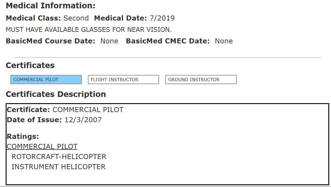
And for the record, the 50 year-old accident pilot did have an instrument rating:
According to the LA Times, Kobe once had the pilot do some extra maneuvers to impress Lakers General Manager Rob Pelinka:
https://www.latimes.com/sports/laker...217-story.html
According to the LA Times, Kobe once had the pilot do some extra maneuvers to impress Lakers General Manager Rob Pelinka:
Shortly after his retirement, the two set out on a helicopter ride and Bryant didn’t tell Pelinka of his daredevil plan. Bryant and the pilot looked at each other and Bryant nodded subtly. Suddenly, to Pelinka’s horror, the helicopter zoomed into military maneuvers designed to terrify the passengers , with the coup de grace coming near the end when the pilot shut off the engine in midair.“My life was flashing before my eyes,” Pelinka told The Times. “I almost had a heart attack. Kobe’s just sitting there calm and collected.”
The helicopter floated toward the ground. After a few moments of thrill/panic, the pilot turned the engine back on and brought the two old friends to safety.
The helicopter floated toward the ground. After a few moments of thrill/panic, the pilot turned the engine back on and brought the two old friends to safety.